Venice on a Budget 2026: How to Explore the City for Less
venice on a budget
This website uses affiliate links which earn a small commission at no additional cost to you.
With its iconic canals, picturesque gondolas, and winding streets, it's no surprise that Venice is considered one of the most romantic cities in the world. But while the city is popular with honeymooners, it's also a huge destination for cruisers and backpackers too.
Venice is beautiful, fun, and full of narrow streets and alleys to get lost in. It's a magical place unlike any other. There are museums, palaces, historic town squares to explore, and endless gelato to eat.
Unfortunately, the city is also expensive and over tourism has become a real problem. No matter what time of the year, you’re going to encounter crowds. In fact, if you come in the summer, it’s going to be unbearable (and if you come when a cruise ship is docked, it’s even more unbearable!)
How to get to Venice
By Train: This is a very convenient way of getting to Venice. You will need to arrive at Venezia Santa Lucia (ignoring Venezia Mestre & Venezia Porto Marghera railway stations). A return train ticket from Padova will cost €10, from Mira-Mirano on the ourskirts of mainland Venice only €6.
Parking: You can drive to Venice although you will have to pay for parking. Tronchetto car park costs €22 for 24 hours.
Getting Around Venice
Water taxis: Water taxis (speedboats) are a wonderful way to get around, but a bit expensive. A trip from the train station to San Marco will cost at least €70!
Vaporettos (water buses): are busses on the water, they leave from the stop called Ferrovia right outside Santa Lucia station. You're looking at €7,50 for a single ride and €21 for a day pass. See https://actv.avmspa.it/en/content/vaporetto. Waterbus line 1 links Piazzale Roma (where the buses and road vehicles arrive), Ferrovia (= Santa Lucia station), Rialto, San Marco & Venice Lido, and runs early until late, usually every 12 minutes or so.
Walk: The main sites are all 20-30 minutes away from the station. You will get lost but should still be able to find the main sites.
San Marco Museum Pass
A single ticket to visit the 4 magnificent buildings and museums of St. Mark’s Square: the Doge’s Palace, the Correr Museum, the Archaeological Museum and the Museum Rooms of the Marciana Library: € 30 (€ 25 if you buy 1 month in advance from https://muve.vivaticket.it/).
Museum Pass
This gives you the same as above but also access to: Museum of Palazzo Mocenigo; Carlo Goldoni’s House; Ca’ Pesaro, International Gallery of Modern Art + Oriental Art Museum; Glass Museum - Murano; Lace Museum - Burano; Natural History Museum; Fortuny Museum. (€ 40. Buy from https://muve.vivaticket.it/)
Chorus Pass
If you want to visit more than 4 churches in Venice it is cost effective to purchase the Chorus Pass (gives free access to 18 churches in Venice): € 12.
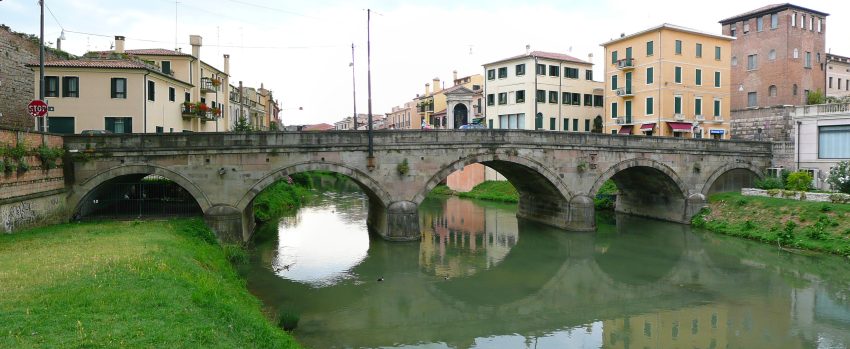
1. Rialto Bridge
Ponte di Rialto Canal Grande
CC BY-SA 4.0 / Veronika.szappanos
There are two ways to get the the Rialto Bridge to the left of the grand Canal, through Santa Croce and San Polo or to the right through the Carnnaregio sestieri and the Jewish quarter.
Santa Croce and San Polo: Start by walking out of the station and turning left to cross the beautiful Ponte degli Scalzi across the Grand Canal, completed in 1934. It’s the elegant stone bridge you’ll see to your left when you walk out of the station. Then follow the many street signs to Rialto, keep the Grand Canal on your left about 5-6 blocks ways from you.
Carnnaregio sestieri and the Jewish quarter: You quickly reach the Chiesa dei Santi Geremia e Lucia, and cross over into the Jewish Quarter, if you want to find out more about this area detour and visit the Jewish Museum of Venice. After walking for about 3 minutes you need to turn of the street you are in to head to the right down Calle del Pistor. Generally follow this street, passing over 4 bridges. When you get to Chiesa Cattolica Parrocchiale dei Santi Apostoli turn off to cross over another bridge, turn immediately left under the arcade. From here you can follow signs for Per S. Marco.
Rialto Bridge was the city’s first bridge over the Grand Canal connecting the highest points on the Venice islands settlement. The first bridge was built in 1180 and the current solid marble one was built in 1588-92.The bridge is an elegant arch with steps and shops, a mass of water traffic passing underneath, and huge numbers of tourists and locals heading across it.
Today, Rialto Bridge is one of the most photographed images in Venice and a major stop on the tourist trail. Rialto Bridge is located about the mid-point of the Grand Canal connecting the main arrival point for visitors at the Railway Station with St Mark’s Square being the main visitor destination. In the immediate area of Rialto Bridge, on the southern bank is the main food market Mercato di Rialto.
For great views of the bridge head towards the nearby Fondaco dei Tedeschi and its rooftop terrace. Book in advance at https://www.dfs.com/t-fondaco/rooftop-terrace-booking/booking/terrace_venice_en.html.
From the Rialto Bridge turn right as you come off the bridge from San Polo. Look for the signpost directing you to St Mark’s Square.
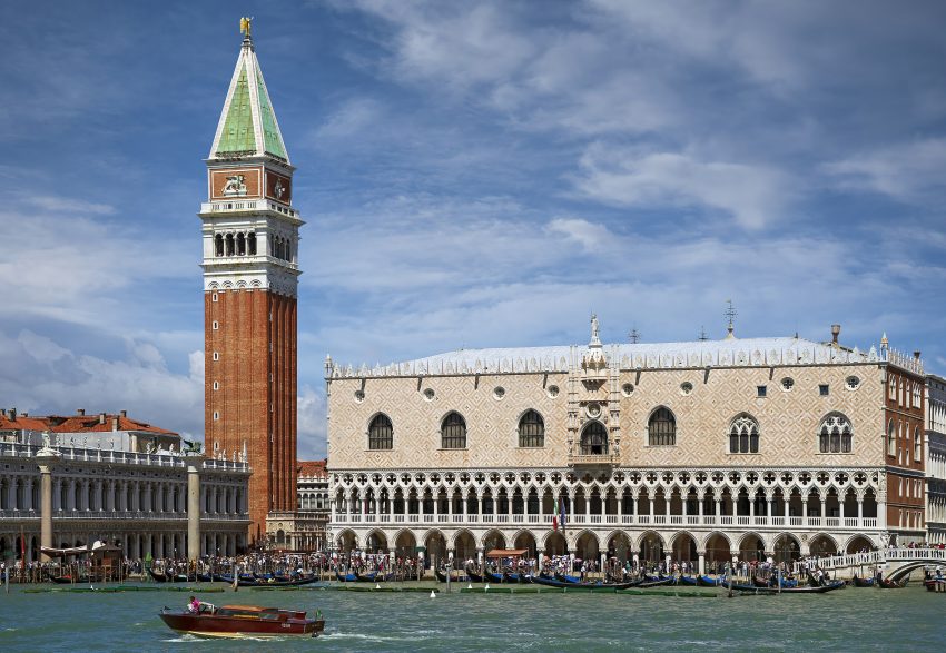
St. Mark’s Basilica, known in Italian as Basilica di San Marco and popularly as San Marco Basilica, is a medieval church in Venice. It is devoted to honouring the remains of St. Mark, the patron Saint of Venice. The Basilica is the pride of Venice and its history dates back to the 9th century. The marvellous architecture blends Byzantine, Romanesque, Islamic, and Gothic influences. St. Mark’s Basilica is open every day from 9:30 AM to 5:15 PM, if you have not booked in advance you need to purchase tickets to the side of the Basilica at Piazzetta dei Leoncini. Tickets cost €3 for the Basilica (although free for prayers, Mass and Service), €10 for the tower and €7 for the Museum & Loggia dei Cavalli (the balcony overlooking the St. Mark’s Square).
The Basilca and St Mark’s Campanile are a very cost effective way of seeing the splendour of Venice.
The Doge’s Palace is one of the symbols of Venice. The palace has been used for everything from the residence of the Doge to the prison of the Venetian republic. Originally a fortified castle founded between the tenth and eleventh centuries. The palace was partially destroyed by a fire and was rebuilt between 1172 and 1178, as was the Piazza San Marco. During this period, the Palazzo was used as a fortress and prison. The structure combines layers of different architectural styles, including Byzantine, Gothic and Renaissance. This impressive building houses paintings by renowned Italian artists such as Titian, Tintoretto and Bellini. The building has been the Doges’ residence and public offices since the old castle was built in 810. Over nearly 1,000 years, 120 doges ruled over Venice from the Doge’s Palace.
The main areas yo will see are:
The armory, a collection of over 2,000 artifacts including a few unusual objects.
The courtrooms where laws were made, and cases were heard.
The doge’s chambers are private rooms containing a shrine, priceless paintings, and two globes showing how the world was understood at the time.
The secret rooms, which include cells, interrogation rooms, and a torture chamber.
The chamber of the Great Council, where important state meetings were hosted.
Traveling to a country with a different currency? Avoid ATM transaction fees and pay in local currency with a Wise Card. Having used it for over 5 years, we've saved loads on fees!
You will head to the island to the south Dorsoduro, which holds the Venice university and will probably a more economical place to eat than St Marks Square! Head west from St Marks Square cross 5 bridges until you get to a large square – Rielo de le Erbe. Head south from here to cross over Ponte dell’Accademia to reach Dorsoduro.
.
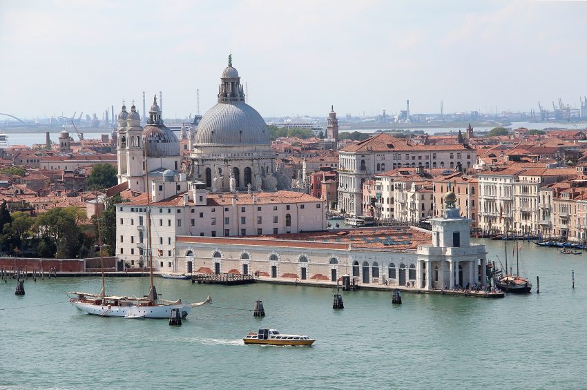
You have a number of options here. Punta della Dogana – Pinault Collection is an art museum, in a triangular former customs house, exhibiting international contemporary artworks. Basilica di Santa Maria della Salute and Gallerie dell’Accademia.
This website uses affiliate links which earn a small commission at no additional cost to you.
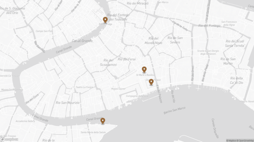
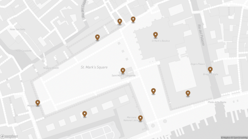
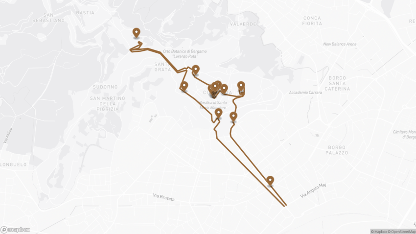
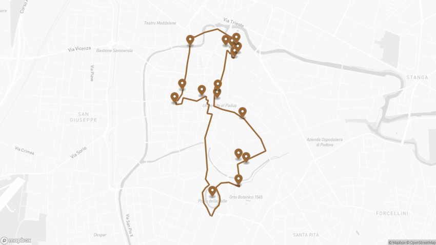
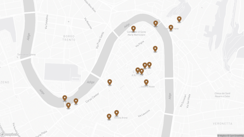
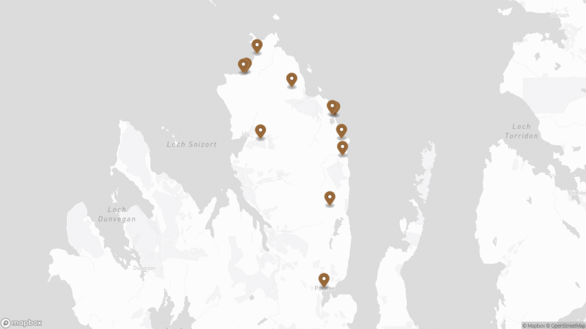
Walking Tour Map
Preview map of the Venice on a Budget: How to Explore the City for Less route in Venice, showing 4 stops. Use the interactive map to zoom and tap markers.
Guide to Visiting Piazza San Marco 2026: Landmarks, Tips & Map
Piazza San Marco
This website uses affiliate links which earn a small commission at no additional cost to you.
The famous Piazza San Marco, known in English as St Mark's Square, is the main public square in Italy's floating city, Venice. With a glowing reputation as one of the finest squares in the world and arguably one of Europe's primary tourist attractions, it certainly has a lot to offer to visitors.
The popular Piazza San Marco, known amongst locals as ‘La Piazza’, is found at the southern base of the Grand Canal. Napoleon called the Piazza San Marco “the finest drawing room in Europe.” Inside it’s surrounded by stunning Baroque and Victorian era buildings and monuments.
When to visit Piazza San Marco?
Due to its popularity, we recommend that you head to PIazza San Marco first thing in the morning to avoid the big crowds. Start your day in this magical square with a sit-down coffee at one of the cafés before moving on to see the rest of Venice. Be careful when visiting during periods of heavy rain, as the square is prone to flooding.
How long is needed to visit Piazza San Marco?
You should reserve at least half an hour to visit Piazza San Marco. A little longer if you want to stop for a coffee or visit the Basilica San Marco or Museo Correr.
What should I wear to visit Piazza San Marco?
Dress comfortably on your trip to Piazza San Marco. You’re likely to be doing a lot of walking and exploring all day, so wear relaxed shoes and clothing. If you’re having lunch or dinner at a particularly exclusive venue, go for something that’s chic yet relaxed.
How to get to the Piazza San Marco?
If on foot just follow the yellow “San Marco” signs on the corners of buildings. The walk from the train station or the Piazzale Roma will take 30 minutes to an hour or more, as long as you don’t stop off on route.
When was Piazza San Marco built?
The piazza was laid out in the 11th Century, when its area was divided in half by a canal near the café tables in the picture. A century later, the canal was filled in, creating the basic shape that exists today. A major building project got underway in the 16th Century, and new stone paving replaced the old bricks in the early 1700s.
What you will find in the Piazza San Marco?
This beautiful Piazza is surrounded by shops, caffè’s and palazzi on three sides including the historic and expensive Caffè Florian. According to local legend Napoleon called the Piazza San Marco “the drawing room of Europe.” A full breakdown is below.
1. Basilica di San Marco
Basilica San Marco
CC BY-SA 2.0 / Gary Ullah
We will start our guide looking at the Basilica di San Marco or St Mark’s Basilica.
Looking at the Basilica you will notice the four bronze horses on the loggia above the porch. originally part of a monument depicting a quadriga (a four-horse carriage used for chariot racing). The horses were placed here after the sack and looting of Constantinople in 1204 The four horses have historically been symbols of the great power of Venice.
The Basilica di San Marco was built in 832 AD to house the remains of the city’s patron, Saint Mark. The holy man’s body was brought from Alexandria, Egypt by two Venetian merchants who smuggled it concealed in the barrels of pork meat, which they rightly regarded the Muslim guards would never touch. According to legend, the night the body arrived in the lagoon, St Mark was greeted by an angel, saying, “Peace be with you Mark, my Evangelist. Here shall your body rest”. Over the centuries, this legend has inspired many works of art.
200 years later, a sumptuous temple was built upon the foundations of an earlier church, and was consecrated when St Mark’s body was interred beneath the high altar. The new basilica was modelled after the celebrated Church of the Apostles in Constantinople. To enhance its opulence, the structure was subsequently clothed in marble and mosaics depicting scenes from the Old and New Testaments, as well as the lives of Christ, Virgin Mary and St Mark himself.
Many of the mosaics were later retouched or remade, as artistic tastes changed and the damaged mosaics had to be replaced, so the ones currently in place represent 800 years of artistic styles. Some of them derive from traditional Byzantine representations and are masterworks of Medieval art; others are based on preparatory drawings made by prominent Renaissance artists from Venice and Florence, such as Paolo Veronese, Tintoretto, Titian, Paolo Uccello, and Andrea del Castagno.
Andrea del Castagno was active at San Marco in the mid-15th century, introducing a sense of perspective largely achieved with architectural settings. Attributed to him is the mosaic in the Mascoli Chapel, depicting the Dormition of the Virgin. Tintoretto, in his turn, created the mosaic in the central nave depicting the Presentation of Jesus at the Temple (16th century), while Titian designed and executed, between 1524 and 1530, the mosaic decoration of the Sacristy vault depicting Old-Testament prophets.
On the north side of the Basilica you will find the Piazzetta dei Leoncini.
The Piazzetta dei Leoncini (Piazzetta meaning small piazza) is named after the two red marble lions sitting in the Piazzetta that were presented to Venice by Doge Alvise Mocenigoin in 1722.
Here is a complete selection of hotel options in Venice. Feel free to review each one and choose the stay that best suits your needs.
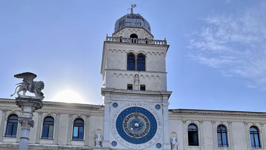
3. Torre dell'orologio
Torre dellOrologio
CC BY-SA 3.0 / Mister No
Turning to our left (anti clockwise) to look at the Torre dell’Orologio.
In a square filled with iconic Venetian buildings, this remarkable Renaissance clock tower holds its own. Its base has always been a favorite meeting point for Venetians as it marks the entrance to the ancient Merceria, one of the busiest streets in Venice, now home to both high-end boutiques and trinket shops.
The tower’s clock itself was made the official timekeeper of Venice as far back as 1858. It notably not only tells the time but is also aid to the astrologer, matching zodiac signs with the position of the sun.
Above the clock’s face, against a field of golden stars, you can see a winged lion of St Mark, symbol of Venice found practically everywhere around the city. Beneath the lion is a statue of the Virgin Mary and Baby Jesus who also seem to be watching over Piazza San Marco.
The two men striking the bell at the extreme top of the clock tower are some of the most peculiar Venetian characters. Originally, these were two shepherds who, but after being reproduced in bronze, grew significantly darker with time, and thus, got the nickname of “Moors”.
If you decide to climb the tower, you may want to book a tour. There are two English tours run every day, each limited to 12 people only. On this tour you will see a secret door and then stop at every level all the way to the top to observe the clock mechanism and other curious things within the tower, along with San Marco square itself down below.
Traveling to a country with a different currency? Avoid ATM transaction fees and pay in local currency with a Wise Card. Having used it for over 5 years, we've saved loads on fees!
4. Procuratie Vecchie & Caffè Lavena
Cafe Lavena Piazza San Marco Venezia
CC BY-SA 3.0 / qwesy qwesy
To the left and running along the north side of the Piazza is a long arcade. These buildings built in the early 16th century are called the Procuratie Vecchie (old) and were the homes and offices of high state officials during the Republic of Venice. Today, at ground level the arcade houses shops and restaurants including the famous Café Lavena.
Established in 1750 café Lavena has its origins in the popular Venice of the 17th century. As the other cafés of St Mark’s Square, Lavena equally had its part in intellectual life in the city. The person who gave lustre to Caffé Lavena, patronizing it from his first coming to Venice and becoming an habitual customer, was the composer Richard Wagner. Almost every day from five to six in the afternoon, Wagner used to visit Caffé Lavena and stay for half an hour, conversing very often with the owner Carlo Lavena.
Other famous persons that has frequented Caffé Lavena include the Venetian violinist Raphael Frontalli, famous composers and writers along with the current plethora of famous and not so famous movie stars that visits during the annual Venice Film Festival. Café Lavena is a great place to sip coffee with your loved one in a sunny afternoon and watch the world go by.
Turn towards the east. The buildings facing the Basilica at the end of Piazza San Marco and to the left of Caffè Lavena is the Procuratie Nuove (New Procuracies) or Ala Napolenica (Napoleon Wing) so called because it was rebuilt by Napoleon in 1810. This wing is occupied primarily by shops as well as the grand staircase leading to the Correr Museum.
Museo Correr is a fine arts museum found in Piazza San Marco. From the Neoclassical Rooms in the Napoleon Wing to the spacious rooms of the Procuratie Nuove. Museo Correr offers a wonderful insights into Venetian history, culture and art. Here you’ll discover the daily life of Venetians through the ages and see fascinating examples of their art up until the early 16th century. Even if you’re not a big admirer of classical art, it’s worth a visit for the amazing views over the Piazza!
Location: Museo Correr, Piazza San Marco, Venice, Metropolitan City of Venice, Italy | Hours: (Summer) 01 April – 31 October; Daily: 10:00–18:00.
(Winter) 01 November – 31 March; Daily: 10:00–17:00.
| Price: €30 (St Mark’s Square Museums ticket, includes Doge’s Palace + Museo Correr + National Archaeological Museum + Monumental Rooms of the Biblioteca Marciana); reduced €15. | Website
Turning left down the southside of the Piazza are the Procuratie Nuove (new) that were built starting around 1582. (Remember, the Procuratie Vecchie were built in the early 1500’s). The ground floor holds more shops as well as the very famous Caffè Florian opened in 1720. When Austria ruled Venice in the 19th century, after the fall of Napoleon, the Venetians sipped their coffee at the Florian while the hated Austrians were at Quadri’s across the Piazza. The upper floors of this section of buildings house the Correr Museum. At the far end is Sansovino’s Liberia dating from the mid-16th century. The building also houses the Museo Archeologico.
Towards the end of the Procuratie Nuove is the Campanile di San Marco
The city’s tallest bell tower was originally constructed in the 12th century, as a combined lighthouse and belfry, and was continuously modified up until the 16th century, when the golden angel was installed on its summit. Back in the day, each of the five bells here had a distinct function: the largest bell tolled the start and the end of a working day; another bell rang midday; two other bells either proclaimed a session of the Senate or called members of the Grand Council to the meetings; while the smallest of the bells gave notice of a forthcoming execution.
It was at the top of this belfry that Galileo Galilei famously demonstrated his telescope to the Venetian Doge on 21 August 1609 – the event commemorated by a plaque at the tower’s observation deck. Still, the most dramatic event associated with the Campanile took place on 14 July 1902, when the tower fell down shortly after giving a sound of warning to the leisurely coffee drinkers at piazza below, sending them run for their lives!
The Venetians put the Campanile back “where it was and how it was”, and the tower is now safe to climb to the very top. Unlike other belfries where you have to brave a narrow, steep spiral set of stairs to reach the top, the Venetian one has an elevator so you can easily get a pigeon’s eye view just for a fee.
Standing 99 meters high, the Campanile is the tallest structure in Venice; an ideal vantage point for observing the cupolas of the San Marco basilica and further afield, including the surrounding lagoon.
Behind the Campanile di San Marco lies the Marciana Library.
The Marciana Library or Library of Saint Mark is a public library in Venice, Italy. It is one of the earliest surviving public libraries and repositories for manuscripts in Italy and holds one of the world’s most significant collections of classical texts. It is named after St Mark, the patron saint of the city.
Location: Biblioteca Marciana, Piazza San Marco, Venice, Metropolitan City of Venice, Italy | Hours: (Summer) 01 April – 31 October: Daily: 10:00–18:00 (last entry 17:00).
(Winter) 01 November – 31 March: Daily: 10:00–17:00 (last entry 16:00). | Price: St Mark’s Square Museums ticket (includes Museo Correr, National Archaeological Museum, and the Monumental Rooms of the Biblioteca Marciana): €30 (full) / €15 (reduced). | Website
The Piazzetta di San Marco is an open space connecting the south side of the Piazza to the lagoon, The Piazzetta lies between the Palazzo Ducale (Doge’s Palace) and the Biblioteca Marciana (St. Mark’s library).
At the open end of the Pizzetta di San Marco are two large granite columns. Sitting on top of the first column is Saint Theodore, the patron saint of the city prior to St. Mark. Saint Theodore is holding a spear with a dragon / crocodile that he is said to have slain. This is a copy of the original which is housed in the Palazzo Ducale (Doge’s Palace). Sitting on the second column is a winged lion of Venice, the symbol of Saint Mark. The original columns are thought to have been erected in 1268. Much activity has taken place between these two columns including gambling and public executions.
The Palazzo Ducale or Doge’s Palace in Venice is one of the main landmarks of the city. The building is an unmistakable testament to Venice’s historic wealth and power. Its facade features a gorgeous pink Verona marble – is a real Gothic masterpiece. For almost 1000 years it was the building from which 120 Doges (or chief magistrates) wielded their awesome power and decided Venice’s fate. This seat of government housed a Senate, court facilities, the secret police, and also prisons. It was also the residence of the Doge of Venice, who – once elected – would remain in his position for life.
The Palace is key to understanding the city’s history. Built on the foundations of a 9th-century fortress, this palace is unquestionably the finest secular European building of its time which, in the course of centuries, had served many purposes, including Doge residence, seat of the Venetian government, court of law, civil office, and even a prison.
First built in the 14th century, much of the original palace was destroyed by fire in the 16th century reducing to ashes most of the art treasures held inside. Some of the greatest Venetian masters of the time, such as Tintoretto, Veronese, Titian, Bellini, and Tiepolo, contributed to restoring the palace to its former glory, recreating gilded stucco, sculptures, frescoes, and canvases.
The interior of the palace – spectacular furnishings and paintings, marvelously adorned ceilings – reveals lavishness on the scale that is hard to match. The most outstanding is the Grand Council chamber, featuring Tintoretto’s “Paradise”, reportedly the world’s largest oil painting. Running up to it, in terms of grandeur, is the Sala dello Scrutinio or the “Voting Hall” embellished with paintings depicting Venice’s glorious past.
By the end of the 13th century, Venice was one of Europe’s richest cities, mostly due to trading spices, silks, and wool between Europe and the Middle East. Its wealthy citizens became patrons of the arts, commissioning fabulous sculptures and paintings to decorate their palaces.
The best vies of the Bridge of Sighs is from the Ponte della Paglia, between the Doge’s Palace and the Prisons’ Palace.
Another grand Venetian landmark, the Bridge of Sighs runs between the Palazzo Ducale and the prisons. The view from the Bridge of Sighs was the last view of Venice that convicts saw before their imprisonment. The bridge’s English name was bequeathed by Lord Byron in the 19th century as a translation from the Italian “Ponte dei sospiri”,from the suggestion that prisoners would sigh at their final view of beautiful Venice through the window before being taken down to their cells.
A local legend says lovers will be granted eternal love if they kiss on a gondola at sunset under the Bridge of Sighs as the bells of the Campanile are ringing.
Location: Ponte dei Sospiri, Piazza San Marco, Venice, Metropolitan City of Venice, Italy | Hours: 24 Hours fromoutside.
(Summer) 1 April – 31 October: Daily: 09:00–19:00.
(Winter) 1 November – 31 March: Daily: 09:00–18:00. | Price: Free to view from outside; to walk across it inside, it’s included with a Doge’s Palace ticket (standard €30 / reduced €15 until 31 December 2025; standard €35 / reduced €15 from 1 January 2026, with cheaper online advance-purchase options). | Website |
This website uses affiliate links which earn a small commission at no additional cost to you.
Walking Tour Map
Preview map of the Guide to Visiting Piazza San Marco: Landmarks, Tips & Map route in Venice, showing 11 stops. Use the interactive map to zoom and tap markers.
This website uses affiliate links which earn a small commission at no additional cost to you.
Nestled in the Lombardy region of northern Italy, the enchanting city of Bergamo has long been a hidden gem in the realm of tourism, quietly awaiting its turn in the spotlight until it was bestowed with UNESCO World Heritage Status.
Resting gracefully on the hillside, fortified by majestic walls, the city extends a warm welcome through its four gates to the world beyond. Città Alta, the Upper Town, beckons visitors with its charming artisan workshops, concealed courtyards, graceful arcades, and the allure of long, meandering shadows.
This quintessential Italian city is a treasure trove of delights, a place where every corner promises to tantalize your senses and spirit. With a rich tapestry of experiences awaiting exploration, Bergamo is a destination where the flavours, culture, and history of Italy come together to create an unforgettable journey for the heart and soul.
By Plane: Bergamo is served by Orio al Serio International Airport (BGY), also known as Milan Bergamo Airport, which handles flights from across Europe and beyond. From the airport, the city center can be reached easily by shuttle bus, taxi, or car hire in around 10-15 minutes. For the best deals and a seamless booking experience, check out these flights to Bergamo on Booking.com.
By Train:Bergamo railway station is directly connected to Milan, Lecco and Brescia (with connections for Lake Garda, Verona, and Venice). The journey times for Milan-Bergamo and Brescia-Bergamo are approximately one hour; the journey from Lecco to Bergamo takes about 40 minutes. Trains depart almost every hour. Use Omnio to easily compare schedules, book train tickets, and find the best prices all in one place for a hassle-free journey across Italy.
As you come out of the train station the tourist office is on your right and the bus station is on your left. There is a 20 minute walk from here to the funicular, alternatively you can catch the bus from here. Head to the bus station ticket office where you can purchase your tourist pass at the bus station ticket office. A tourist ticket day pass ticket for about 4 Euro which will allow you to ride the bus up to the old town, as well as take 2 funiculars.
You will need to catch the T1 Line Stazione – Porta Nuova – (Roma) – (Vitt Emanuele) – Funicolare. Buses leave every 5-10 mint
By Car: Parking is generally free only within the white lines, while it is subject to payment within the blue lines. The yellow-striped car parks are reserved for residents. You can park by the train station at the Parcheggio Ex Gasometro off Via San Giovanni Bosco and head to the train station. It is not advisable to walk back here in the dark! If you are looking to rent a car in Italy I recommend having a look at Discover Cars, first, as they compare prices and review multiple car rental agencies for you.
Where to Stay in Bergamo
To make the most of visiting Bergamo and this walking tour then you should consider staying overnight in the centre, particularly near the Città Alta, where most of the historic landmarks and charming streets are within easy walking distance. In the heart of the old town, Relais San Lorenzo offers a boutique experience with historic charm and modern comforts. Another excellent option nearby is GombitHotel, which places you steps from Piazza Vecchia and the Basilica of Santa Maria Maggiore. For a more traditional hotel experience, Hotel Piazza Vecchia provides elegant rooms right in the historic centre.
In the lower city, the Città Bassa, NH Bergamo offers contemporary accommodations and easy access to transport links, shopping, and restaurants. Excelsior San Marco Hotel is another popular choice, blending comfort with convenience near the central squares. For a more intimate stay, B&B Hotel Bergamo offers modern rooms and a welcoming atmosphere, ideal for those wanting to explore both the upper and lower parts of the city.
A Brief History of Bergamo
Bergamo is a city of two distinct areas: the historic upper town, Città Alta, perched on a hill, and the modern lower town, Città Bassa, which developed in the plains. The city's origins trace back to pre-Roman and Roman times, with the Torre di Gombito, a medieval tower built in the 11th century, serving as a remnant of its early fortifications. During the Middle Ages, Bergamo grew as a fortified commune, with civic and religious buildings like Piazza Vecchia, Palazzo del Podestà, and the Basilica di Santa Maria Maggiore becoming the heart of city life. The construction of the Cappella Colleoni in the 15th century, a masterpiece of Renaissance art and architecture, further highlighted Bergamo's prominence as a center of culture and devotion.
Under Venetian rule from the 15th to the 18th centuries, the city's defences were expanded, leaving the iconic Venetian Walls, Porta San Giacomo, and Porta Nuova as enduring symbols of this era. The Torre del Campanone, the battlements, and Rocca Museum atop the hill underscore the city's strategic importance, while the funicular linking the upper and lower towns demonstrates how Bergamo has blended its medieval heritage with modern transport solutions. Religious sites, including the Battistero di Bergamo, also bear witness to the city's long-standing ecclesiastical significance.
Bergamo’s cultural and scientific life has flourished alongside its architecture. Institutions such as the Museo di Scienze Naturali e Archeologico preserve the region’s natural and historical heritage, while Torre Castello San Vigilio offers panoramic views over the city and surrounding plains. Walking the historic streets and climbing the funicular reveals layers of Bergamo’s history-from its medieval origins to Venetian fortifications, Renaissance art, and modern developments-making it a city where the past is alive in every piazza and tower.
Guided or Self-Guided Tour of Bergamo?
While exploring Bergamo’s Upper Town independently is rewarding, a guided tour can provide deeper insights into its history and landmarks. The Bergamo 2.5-Hour Private Upper Town Tour offers a comprehensive exploration of the city’s highlights, including Piazza Vecchia, the Basilica of Santa Maria Maggiore, and the Colleoni Chapel. Led by knowledgeable guides, this tour enriches your understanding of Bergamo’s cultural heritage.
Your Walking Tour of Bergamo
This guide highlights Bergamo’s main attractions, but the city’s charm lies in its details. Take time to explore the lesser-known alleys, sample local delicacies, and enjoy the vibrant atmosphere of its historic squares. Whether you’re a history enthusiast or a casual traveler, Bergamo’s Upper Town offers a memorable experience.
1. Porta Nuova
Bergamo Porta Nuova
CC BY-SA 3.0 / Van Loon
From the train station walk down Viale Papa Giovanni XXIII (Pope John XXIII) to the Porta Nuova (8mins).
The first thing you will see of the Porta Nuova are a pair of colonnaded, neoclassical buildings dating from the 1830s. These were old customs houses by the city gate into the lower town of Bergamo.
Carry on straight down the via Roma to the Bergamo funicula (11 mins).
Take the most impressive means of transport into the old city. The Lower Funicular has been connecting the centre of Bergamo with the Upper Town (“Città Alta”) for more than 120 years, more precisely with Piazza Mercato delle Scarpe, where many business activities used to be carried out. The square (whose name means “shoes market square”) was used as a shoes market since 1430, while the building overlooking the square used to be the headquarter of the shoemakers’ guild and it currently hosts the funicular station.
Here is a complete selection of hotel options in Bergamo. Feel free to review each one and choose the stay that best suits your needs.
3. Rocca Museum
Bergamo Rocca
CC BY-SA 4.0 / Lauramagri712
From the Stazione superiore funicolare (Funicular upper station), you come out into the Piazza Mercato delle Scarpe. Go directly opposite and up the Via Alla Rocca, following it to the right.
The Rocca Museum is an imposing 14th-c. stronghold with a tower offering panoramic views & a museum of Bergamo’s history.
Traveling to a country with a different currency? Avoid ATM transaction fees and pay in local currency with a Wise Card. Having used it for over 5 years, we've saved loads on fees!
4. Torre di Gombito
Bergamo Torre del Gombito
CC BY-SA 4.0 / Lauramagri712
Head back to Piazza Mercato delle Scarpe. Go directly opposite and walk up Via Gombito for about 1 minutes and you will reach the tourist office and Torre di Gombito.
You used to be able to climb the 263 steps to the top of the 12th-century Gombito Tower, this is not possible for the foreseeable future.
Location: Torre del Gombito, Bergamo, Province of Bergamo, Italy | Hours: Visits must be reserved in advance at the tourist office, which is at the base of the tower, and leave at 10am, 10.45am, 11.30am, 2.30pm, 3.15pm and 4pm on Mondays.
Carry on up the Via Gombito to reach Piazza Vecchia.
Piazza Vecchia the core of Città Alta. As you enter it on your left is the Palazzo Nuovo or New Palace, which served as Bergamo’s Town Hall until 1873. Today it is the seat of the Angelo Mai Library. Its incredible collection includes ancient and precious books: incunabula, books from the 1500s, engravings, manuscripts and other inestimable artefacts making it one of the most outstanding libraries in Italy. Directly opposite this is the Palazzo della Ragione, the oldest municipal seat in Lombardy. In the northwest side of Piazza Vecchia, the fresco-dappled Palazzo del Podestà was traditionally home to Venice’s representative in Bergamo. Today, the medieval building houses a small imaginative museum with audiovisual and interactive displays that tell the story of Bergamo’s Venetian age. Admission also includes access to the Torre del Campanone, with superb views over Bergamo.
Basilica of Santa Maria Maggiore 12th 14th centuries Bergamo
CC BY-SA 2.0 / Prof. Mortel
Walk directly behind the Palazzo della Ragione to reach the Piazza del Duomo (Cathedral Square).
On your right you will see the octagonal Battistero di Bergamo, directly in front of you the Cappella Colleoni a 15th-century funerary chapel with its coloured marble exterior & frescoed ceiling inside. To the left and behind the Cappella Colleoni is the Basilica di Santa Maria Maggiore built in 1137 and to its right with its neo-classical facade the Cathedral of Sant’Alessandro, built in 1459.
The Cappella Colleoni, situated on the north side of the Basilica di Santa Maria Maggiore, stands as a splendid mausoleum and chapel that was constructed between 1472 and 1476. Its purpose was to honor the memory of Bartolomeo Colleoni (c. 1400–1475), a renowned Bergamese mercenary commander who led the armies of Venice in campaigns across northern Italy. Bartolomeo Colleoni now rests within this magnificent tomb.
Beneath the central dome of the chapel, Venetian rococo master Giambattista Tiepolo (1696–1770) adorned the interior with exquisite frescoes. The exterior of the chapel is adorned with a stunning display of red and white marble, showcasing an authentic Italian Renaissance masterpiece. Inside, you will encounter a captivating array of artworks, including the equestrian statue of Bartolomeo Colleoni, the marble sarcophagi, the exquisite tomb of his daughter Medea, and the intricately designed wooden desks.
The Baptistery of the Cathedral is not just a physical structure but a profound embodiment of history, art, and faith.
It is a place steeped in history, spanning centuries. Its origins trace back to 1340 when it was built by Giovanni da Campione. However, it carries the legacy of an ancient baptistery that had stood near the Cathedral since the early days of Christianity, dating back to the 5th century. The Baptistery’s connection to the Cathedral is longstanding. Initially situated within the confines of S. Maria Maggiore, which, until the 15th century, was part of the same cathedral complex as the ancient church of S. Vincenzo. When S. Maria became independent from the Cathedral, the Baptistery was dismantled in 1660 and relocated first to the cloister of the Rectory and later, in 1898, to its present location in front of the Cathedral.
As a place of art, the Baptistery holds significant artistic treasures. It houses two remarkable sculptural cycles crafted by Giovanni da Campione: eight panels depicting key events from the life of Jesus Christ (such as the Annunciation, Nativity, Adoration of the Magi, Presentation in the Temple, Baptism, Capture and Condemnation, Crucifixion, Deposition, and Resurrection) within its walls. On the external corners, statues representing the theological Virtues (Faith, Hope, Charity) and the Cardinal Virtues (Justice, Prudence, Fortitude, Temperance) are displayed, with the virtue of Patience completing the ensemble. These original Gothic architectural elements were complemented during the relocation process.
Above all, the Baptistery is a place of faith where Christians receive the sacrament of baptism and embark on their journey of bearing witness to their commitment to Christ. It is where they are baptized and symbolically participate in the death and resurrection of Christ, supported by the grace received in baptism and nurtured through the other sacraments. The Baptistery’s octagonal shape symbolizes the fullness of God’s gift, the resurrection of Christ, and the new creation that baptism signifies.
This sacred space serves as a powerful reminder of the Christian heritage of our city and civilization, connecting us to our deep spiritual roots.
In the center of Piazza Vecchia stands the Civic Tower, fondly referred to as the Campanone. This impressive structure soars to a height of 52.76 meters and grants visitors a truly awe-inspiring panoramic view of the historic old town.
At its summit, which can be reached either by ascending 230 steps on foot or more comfortably via an elevator, resides the largest bell in Lombardy. To this day, at the stroke of 10 pm each night, the Campanone tolls one hundred times, serving as an enduring reminder of a bygone era when the city gates along the walls were sealed during the rule of the Venetians.
Adjacent to the Palazzo della Ragione, symbolizing civil authority, and the Bishopric, representing religious authority, the Palazzo del Podestà stands as a commanding presence overseeing the two main squares that served as the epicenters of medieval Bergamo: Piazza Duomo and Piazza Vecchia.
Constructed towards the conclusion of the 12th century, this magnificent palace was commissioned by the influential Suardi-Colleoni family, who generously offered it to the city. Over time, it evolved into the official residence of the Podestà, a foreign governor appointed for a six-month term to govern the municipality. In times of necessity, the Podestà had access to the prisons situated beneath the Civic Tower.
During the extensive period of Venetian rule, which commenced in 1428, the building underwent significant expansion and structural modifications, transforming it into the central hub for the administration of justice within the city.
Head back to the Piazza Vecchia and leave by the north west alley into Via Bartolomeo Colleoni. As you come out into the open in front of you is the impressive Cittadella
Head diagonally across the Piazza della Cittadella and through the arch. With the views on your left walk 50 meters and you will see some brown signs pointing to the left towards the Funicular San Vigilio and the Castello San Vigilio. You need to pass through Porta Sant’Alessandro to be back within the city walls. Catch the Funicolare S. Vigilio to the top of the hill.
Parco Del Castello Di San Vigilio is clearly visible symbol of power, the Castle of San Vigilio has for centuries been the residence Bergamo rulers for centuries. It is located 496 meters above the sea level, on top of the hill that gives it its name, overlooking the Città Alta: that’s why it used to have a strategic role in case of attacks.
Head back down the funicular and through the Porta Sant’Alessandro. bear left and walk down the Viale delle Mura. The Cittadella is the first lage building bloack on your right, the second being the Episcopal Seminary Giovanni XXIII. As the road turns sharply to the left you come to the Parco di San Giovanni or Park of St John.
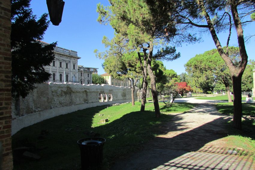
Bergamo’s magnificent Venetian Walls encircle a circuit spanning over six kilometers, making it the ideal locale for a romantic stroll and the perfect vantage point to savor breathtaking sunsets. These walls have safeguarded the splendors of the Upper Town for more than four centuries and are honored as a UNESCO World Heritage site, a testament to their invaluable artistic and cultural significance.
Their construction commenced in 1561 under the jurisdiction of the Republic of Venice, initiated as a defense against potential enemy incursions. Remarkably, history, perhaps entranced by their sheer beauty, spared these fortifications from ever experiencing a siege. Consequently, they have endured virtually unchanged to the present day.
Comprising 14 bastions, 2 platforms, 100 embrasures for cannons, 2 armories, and four gates, not to mention an intricate network of underground structures featuring sallies, passages, and tunnels, the Venetian Walls offer a wealth of exploration opportunities. Don’t miss the chance to venture within the walls and explore the casemates of San Michele and San Giovanni!
However, the construction of these walls necessitated the demolition of over 250 buildings, including 8 religious establishments like the Sant’Alessandro Cathedral and the Dominican convent of Santo Stefano. Consequently, eight excommunications were issued during the course of these works.
A multitude of workers, under the guidance of both Venetian and Bergamo architects, were engaged in raising these formidable defenses due to the sheer scale of the undertaking.
The UNESCO World Heritage designation integrates the Venetian Walls into a broader, transnational site titled “Venetian fortifications between XVI and XVII Century,” intended to highlight the collective defensive systems erected by the Republic of Venice during the 16th and 17th centuries.
It’s noteworthy that some sections of these walls can trace their origins back to the Roman era, with documentation dating as far back as the 8th century. Remnants of these ancient fortifications can still be observed in locations such as via Vagine, beneath the Santa Grata cloister, and on the left side of Viale delle Mura, to the west of the funicular layout (formerly via degli Anditi). Although these ruins were in dire disrepair by the early 16th century, they were nearly entirely replaced by the new Venetian Walls, resulting in a completely fresh defensive perimeter without any vestiges of the prior fortifications.
Follow the wall of the city around until you come to the Porta San Giacomo.
Landmark white marble gate & stone viaduct overlooking the plain, preserved from a ruined city wall.
from here either take the Via S. Giacomo to the funicular, which yo catch to get to the bottom, or walk down the ramp and head left to catch the bus back to the station.
This website uses affiliate links which earn a small commission at no additional cost to you.
Padua, a historic city in Italy’s Veneto region, is renowned for its rich artistic heritage, medieval architecture, and vibrant academic atmosphere. Home to one of the world’s oldest universities and the exquisite frescoes of Giotto, Padua offers a captivating blend of cultural treasures. Exploring Padua on foot allows visitors to fully immerse themselves in its historical significance and architectural beauty.
Whether you’re admiring ancient chapels or wandering sunlit piazzas, Padua invites you to uncover centuries of creativity, faith, and scholarship.
By Plane: The nearest major airport to Padua is Venice Marco Polo Airport (VCE), located about 40 km from the city center, with regular flights from across Europe and beyond. From the airport, travelers can reach Padua by shuttle bus, train from Venice Mestre station, or car hire in roughly 40-50 minutes. For the best deals and a seamless booking experience, check out these flights to Padova on Booking.com.
By Train: Padua is easy to reach by train from many other nearby Italian cities. All the trains that move between Milan-Venice and Bologna-Venice stop in Padua. To get to the centre from the train station walk down Corso del Popolo. Use Omnio to easily compare schedules, book train tickets, and find the best prices all in one place for a hassle-free journey across Italy.
By Car:Padova is strategically located at the crossroads of major motorways in Italy. For those traveling from the west (Venice) to the east (Milan), you can access the A4 motorway (Venice-Milan) and take the Padova Est exit if you are coming from Venice or the Padova Ovest exit if you are arriving from Milan. If your journey brings you from the south (Bologna) to Padova, you'll be on the A13 motorway (Bologna-Padova). Take the Padova Sud exit, and from there, you can follow the signs guiding you to the center of Padova or continue in the direction of the A4 motorway (Milan-Venice) if you wish to travel east.
Warning: The centre of Padova is a Traffic-Restricted Area (ZTL).
Parking: The most convenient parking is Piazza Rabin, just to the south of Prato della Valle – about € 1.50 an hour. From here head north through the arch to arrive at Prato della Valle.
Where to Stay in Padua
To make the most of visiting Padua and this walking tour then you should consider staying overnight at the centre, where most of the city’s historic landmarks and charming squares are within easy walking distance. Close to Prato della Valle and the heart of the old town, Hotel Belludi 37 offers a boutique experience in a historic building with modern comforts. Another excellent choice nearby is Hotel Casa del Pellegrino, perfectly situated for exploring the Basilica of Saint Anthony and other central attractions. For a more classic hotel experience, NH Padova provides contemporary rooms and easy access to the city’s main squares.
Closer to the university area, Hotel Grand’Italia offers a historic façade combined with modern amenities, making it ideal for visitors who want to be near both the academic and cultural heart of the city. Hotel Al Santo is another good option, located steps from the Basilica and Prato della Valle, offering comfortable accommodations with a local feel. For travelers looking for convenience and modern design, Padova Center Hotel places you within easy reach of transport links while still being a short walk from the historic centre.
A Brief History of Padua
Padua is one of Italy’s oldest cities, with origins dating back over 2,500 years to pre-Roman times. Its Roman heritage is still visible in sites such as the Roman Arena and the Arena Gardens, which once hosted spectacles and civic gatherings. During the Middle Ages, Padua became a thriving cultural and religious hub. The construction of the Basilica of Sant’Antonio in the 13th century, a pilgrimage site dedicated to Saint Anthony, established the city as a spiritual centre. Nearby, Piazza del Santo and the Equestrian Statue of Gattamelata, created by Donatello in the 15th century, celebrate the city’s medieval and Renaissance achievements, while the Palazzo della Ragione, dating from 1218, reflects Padua’s role as a commercial and civic hub.
The city's intellectual life flourished with the foundation of the University of Padua in 1222, one of the world's oldest universities, housed in the historic Palazzo Bo. Padua became a centre of learning and science, exemplified by the creation of the Orto Botanico in 1545, the world's first university botanical garden. The city also embraced art and culture, as seen in the Cappella degli Scrovegni, whose Giotto frescoes remain a masterpiece of early Renaissance painting. Cultural institutions such as Musei Civici di Padova and MUSME - Museum of the History of Medicine further highlight the city's long-standing commitment to knowledge, art, and civic pride.
Padua's urban landscape combines history with public spaces that have defined city life for centuries. The grand Prato della Valle, one of Europe's largest squares, became a central gathering place in the 18th century. Iconic civic buildings such as the Palazzo Zuckermann, Chiesa degli Eremitani, and the Torre dell'Orologio in Piazza dei Signori reflect successive periods of architectural and civic development. Cafe Pedrocchi, established in 1831, became a symbol of social and intellectual life, while the Duomo di Padova and Ponte Molino showcase the city's religious and infrastructural heritage.
Guided or Self-Guided Tour of Padua?
Padua’s compact layout and scenic piazzas are easy to explore independently, but for deeper historical context, consider a guided tour. The Padua Small Group City Tour with the Scrovegni Chapel takes visitors on an insightful journey through Padua’s cultural heart. Highlights include Giotto’s frescoes in the Scrovegni Chapel, the elegant Caffè Pedrocchi, and Europe’s second-largest square, Prato della Valle.
Your Walking Tour of Padua
This blog highlights Padua’s main attractions, but your journey could easily expand-perhaps with a riverside stroll, museum visit, or glass of Prosecco in one of Padua’s timeless cafés.
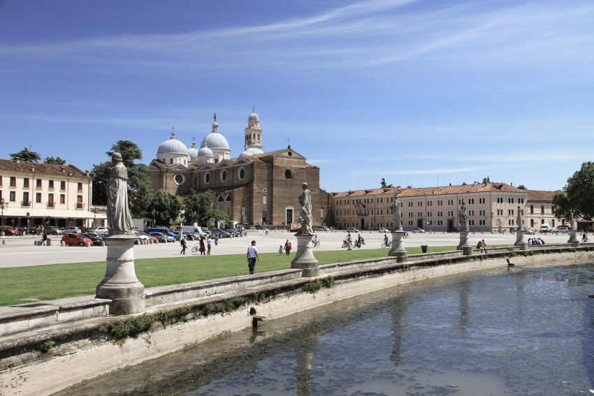
1. Prato della Valle
Prato della Valle in Padua
CC BY-SA 4.0 / AnatolyPm
Prato della Valle, Italy’s largest square, stands as one of Padua’s most iconic attractions. Covering an expansive area of 90,000 square meters, it boasts an elliptical shape. The square is bordered by a canal that encircles an oval space known as the Isola Memmia, named after Andrea Memmo, the visionary behind Prato della Valle in the 18th century.
Two concentric rings of statues grace the perimeter of the canal, totaling 78 in all, each representing prominent figures intertwined with the rich history and culture of Padua. For instance, statue number 36 pays homage to Galileo Galilei, who famously declared that he “spent the happiest 18 years of his life living and teaching in Padua.” Statue number 35 commemorates the renowned humanist and poet Petrarch, who was a frequent visitor to Padua in the 14th century. Statue number 21 immortalizes the illustrious Renaissance artist Andrea Mantegna, who both studied and worked in Padua. Notably, pinpoint 12 on this list leads to the opportunity to view Mantegna’s renowned cycle of frescoes in the Church of the Eremitani in Padua.
Prato della Valle serves as a vibrant hub for many of Padua’s major events and festivals. It regularly hosts bustling markets, featuring an array of fresh produce, vintage items, and assorted treasures.
Take a moment to explore Prato della Valle, and you’ll discover a treasure trove of picturesque opportunities. The stately Lodge Amulea and the imposing structure of the Basilica of Santa Giustina present splendid subjects for your photography. Be sure to capture the beauty of these landmarks with your camera to preserve the memories of your visit.
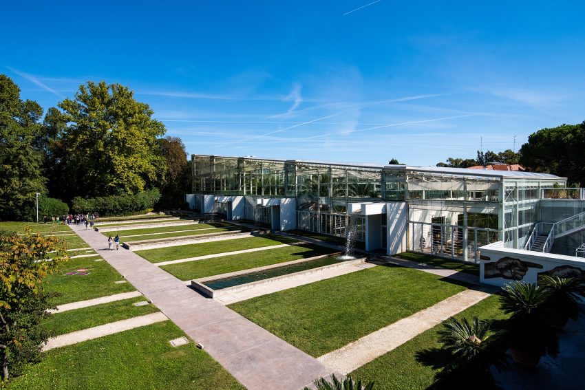
Walk straight through the oval park, then walk anti-clockwise around it before turning onto Via Beato Luca Belludi. Quickly turn off to the right to walk down the pedestrianised Via Donatello, after 200m you arrive at the University of Padua Botanical Gardens.
The Orto Botanico di Padova is a small botanical garden in Padua, in the northeastern part of Italy. Founded in 1545 by the Venetian Republic, it is the world’s oldest academic botanical garden that is still in its original location. The garden – affiliated with the University of Padua – currently covers roughly 22,000 square meters, and is known for its special collections and historical design.
Here is a complete selection of hotel options in Padova. Feel free to review each one and choose the stay that best suits your needs.
3. Piazza del Santo & Equestrian Statue of Gattamelata
Piazza del Santo Padova
CC BY-SA 3.0 / joergens.mi
Head back to the entrance of the gardens. After crossing the small bridge, turn off Via Donatello and walk up Via Orto Botanico until you reach the Piazza del Santo.
One of the main reasons for visiting the Piazza del Santo is it see the Equestrian Statue of Gattamelata. It is one of the most famous statues in Italy, made by Donatello in 1446, it represents Erasmo da Narni, who was a soldier fighting for the church and for the Venetian Republic. His nickname was Gattamelata. It was the first equestrian statue of this size since antiquity and was commissioned by the soldier’s wife and son. The house in which Donatello lived during his time in Padua is located opposite the Basilica.
Location: Piazza del Santo, Padua, Province of Padua, Italy | Hours: The square is accessible at all times; the basilica, Museo Antoniano, Scuola di Sant’Antonio and Oratorio San Giorgio each have their own visiting hours, usually posted on site. | Price: Piazza del Santo is free to enter; the basilica is free, while some adjoining museums and chapels may charge a small entrance fee or request a donation.
Traveling to a country with a different currency? Avoid ATM transaction fees and pay in local currency with a Wise Card. Having used it for over 5 years, we've saved loads on fees!
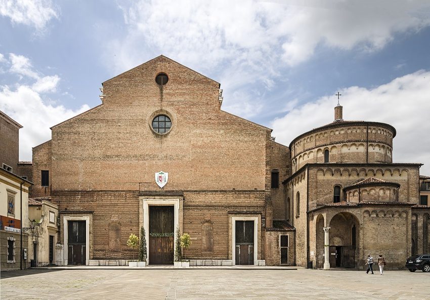
4. Basilica of Sant’Antonio
Basilica di Sant Antonio
CC BY-SA 4.0 / Chris Light
Padua is affectionately known as the City of the Saint due to the deep and heartfelt devotion of its locals to St. Anthony. The term “Il Santo” is used by the citizens of Padua to refer both to the Saint himself and to the exquisite basilica that enshrines his relics.
Originally constructed between 1232 and 1310, with subsequent modifications over the centuries, the Basilica of St. Anthony stands as Padua’s most significant religious landmark. Annually, it welcomes five million pilgrims. This basilica is a must-visit, showcasing a harmonious blend of architectural styles, magnificent frescoes, numerous chapels holding precious relics, and a wealth of masterpieces.
Key highlights within the basilica include:
Chapel of St. Anthony: A splendid Renaissance masterpiece where visitors come to offer their prayers before the Saint’s tomb.
Chapel of the Relics (Treasury Chapel): Here, you can behold the Incorrupt Tongue of St. Anthony, along with numerous other revered relics. The meticulous craftsmanship and artistry evident in the design and creation of the reliquaries, chalices, and religious artifacts preserved here are truly breathtaking.
Presbytery and Main Altar: This area is a magnificently frescoed and ornamented space, adorned with 15th-century statues and bas-reliefs by the renowned artist Donatello. These are among the most prized artistic treasures within the Basilica.
Cloisters: These cloisters are not only beautifully maintained but also house fragments of preserved frescoes, providing a glimpse into the basilica’s rich history.
Museums of the Basilica: These museums offer an opportunity to delve deeper into the life and work of St. Anthony and to admire a collection of artworks owned by the Basilica.
Oratory of St. George and School of the Saint: Two small buildings adjacent to the main body of the Basilica. The first hosts one of the most precious 14th-century fresco cycles. The second features a series of frescoes by Titian and other renowned local painters.
From the square head away from the Equestrian statue of Gattamelata up the Via del Santo. At the end when you reach Via S. Francesco turn right to see the MUSME – Museo di Storia della or left to see the MUSME – Museo di Storia della or right to reach the Palazzo Bo.
MUSME is a collection of exhibits that describe the history of medicine. Since the University of Padua houses one of the oldest medical schools in the world, it is fitting for this museum to be located in the historic center of Padua, within walking distance of the medical school. Exhibits explain gross anatomy, the development of pharmacology, surgery and also focus on the evolution of medical education.
Come out of the building and turn right onto Via S. Francesco. You will pass Piazza Antenore which has the Tomb of Anthenor. This is a historical medieval tomb, falsely attributed to the mythical founder of Padua, more probably the remains of a Hungarian warrior and not the Trio prince.
Opposite this is the Palazzo Romanin Jacur. A 14century palace that Dante lived in Padua during his exile.
At the end of the piazza is the location of the Ponte San Lorenzo, the remains of a segmental stone bridge with 3 arches, built by the Romans from 47—30 BCE. Unfortunately now inaccessible and not visible from the street.
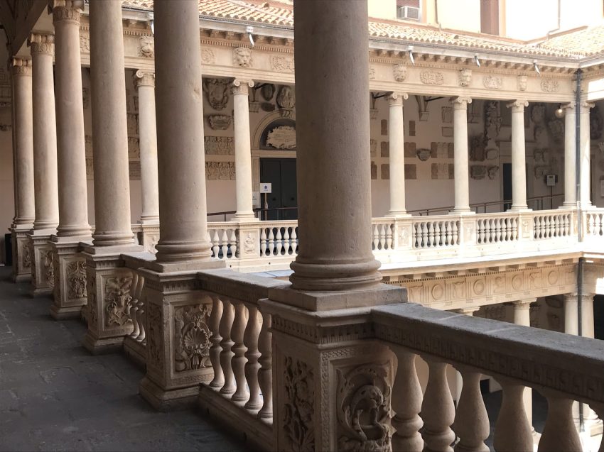
At the next block turn north onto Via VIII Febbraio to reach Palazzo Bo.
Take a guided tour of the University of Padova, one of the oldest in Europe, where Galileo taught for a dozen years, and which awarded the first Ph.D. in the world to a woman in the 17th century). It is a fabulous renaissance building and tiered courtyard that housed the main campus of the University of Padua’s medical school for centuries. As such, it is decorated to the hilt with the family crests of all the illustrious teachers and alumni who have walked these old stone floors.
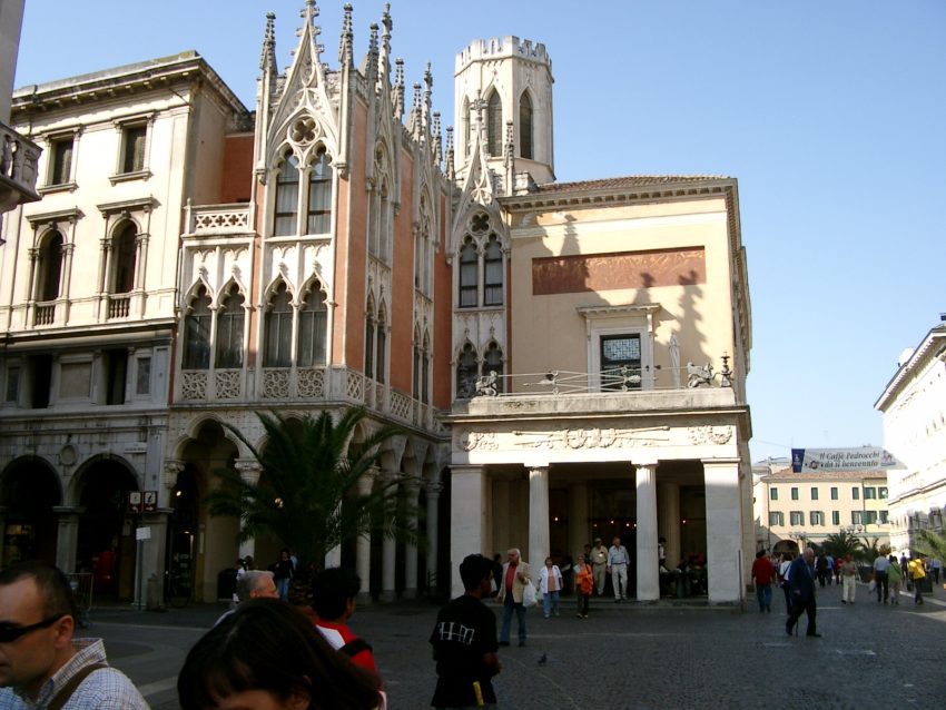
Carry on north on Via VIII Febbraio to reach Piazzetta Cappellato Pedrocchi, or to skip it take first left to go straight up Via Guglielmo Oberdan another bloack to see Pedrocchi Café.
Walk past the historic Pedrocchi Café. Known for its part in the 1848 riots against the Habsburg monarchy, as well as for being an attraction for artists over the last century from the French novelist Stendhal to Lord Byron to the Italian writer Dario Fo. Pricing is as you would expect for a historic building.
Head north out of Piazza Cavour, one of the main squares, dedicated to Camillo Benso, Count of Cavour, one of the most important Italian politic leaders at the time of of early Italian independence wars and first Prime Ministero of Italian Kingdom in 19th century. Continue past Piazza Garibaldi, leaving it to walk along Corso Guiseppe Garibaldi. You will see the Roman Arena on your right and the The Palazzo Zuckermann Museum on your left.
The Roman Arena of Padua was an amphitheatre used for gladiator games in the ancient Patavium. The Arena ruins are now part of the Giardini dell’Arena park. Today, only a few ruins remain part of the bearing walls and a series of arches. The remains of the Arena have recently undergone a cleaning and restoration process. In parallel, an excavation project is also underway to bring to light the original structures of the Arena, floors and foundations, buried over the centuries by numerous stratifications and subsequent building works.
Location: Arena Romana di Padova, Piazza Eremitani, Padua, Province of Padua, Italy | Hours: The surrounding gardens keep standard daylight hours, typically opening in the morning and closing around dusk; check local information for seasonal variations. | Price: Access to view the arena ruins within Giardini dell’Arena is generally free, though charges apply for nearby museums and the Scrovegni Chapel.
The palazzo is home to the Museum of Applied and Decorative Arts, with over two thousand exhibits that might be called the hidden patrimony of the Padua City Museums. It also houses the Museo Bottacin, which has a rich collection of medals and coins. The neoclassical facade of the building has elements influenced by the Liberty style – the Italian version of Art Nouveau.
The Church of the Eremitani (Chiesa degli Eremitani) is a 13th-century Gothic-style church known for its rich collection of artworks. Tragically, during the Second World War, the church suffered damage when it was mistakenly bombed by the Allied Forces. It is said that the proximity of the German headquarters in Padua to the church led to this unfortunate incident. Despite being on the ‘do not bomb’ list of cultural heritage sites, it became a casualty of war.
The most severe damage was inflicted on the church’s Ovetari Chapel, which had been adorned with frescoes by a group of renowned Renaissance artists in the 15th century. Among these artists, Andrea Mantegna’s name shines brightly. Mantegna had a unique approach to painting, which resembled the work of a sculptor wielding a paintbrush. His skill in depicting finely sculpted bodies, expressive faces, and intricate architectural backgrounds has garnered admiration for centuries. Many of his paintings now grace famous museums and galleries worldwide.
When the bombs struck the Church of the Eremitani on March 11, 1944, Mantegna’s frescoes crumbled into a staggering 88,000 fragments. This incident represented Italy’s most devastating art loss during the war. Only many decades later, thanks to advanced software, were the frescoes meticulously reconstructed, resembling a massive jigsaw puzzle with numerous missing pieces. Observing the restored frescoes in person brings to light the truly devastating impact of war on cultural treasures.
Location: Chiesa degli Eremitani, Piazza Eremitani, Padua, Province of Padua, Italy | Hours: Hours can vary by season and liturgical calendar, but the church is generally open daily with a midday break; check current times locally or via Padua’s tourist information. | Price: Entry to the church itself is typically free, though donations are welcome; combined tickets apply only to nearby museums and the Scrovegni Chapel.
Walk anti clockwise around the arena and you will come to the Musei Civici di Padova.
Part of the Eremitani Civic Museums complex, the palazzo houses the Museum of Applied and Decorative Arts and the Bottacin Museum in its rooms. The museum complex is headquartered in Piazza Eremitani, in the cloisters of the former Augustinian monastery adjacent to the Church of the Eremitani. But the Eremitani Civic Museums encompasses a series of monumental sites and various museums located in different buildings in Padua, showcasing an expansive collection ranging from archaeological objects to medieval and modern art.
Padova Cappella degli Scrovegni Innen Langhaus West
CC BY-SA 4.0 / Zairon
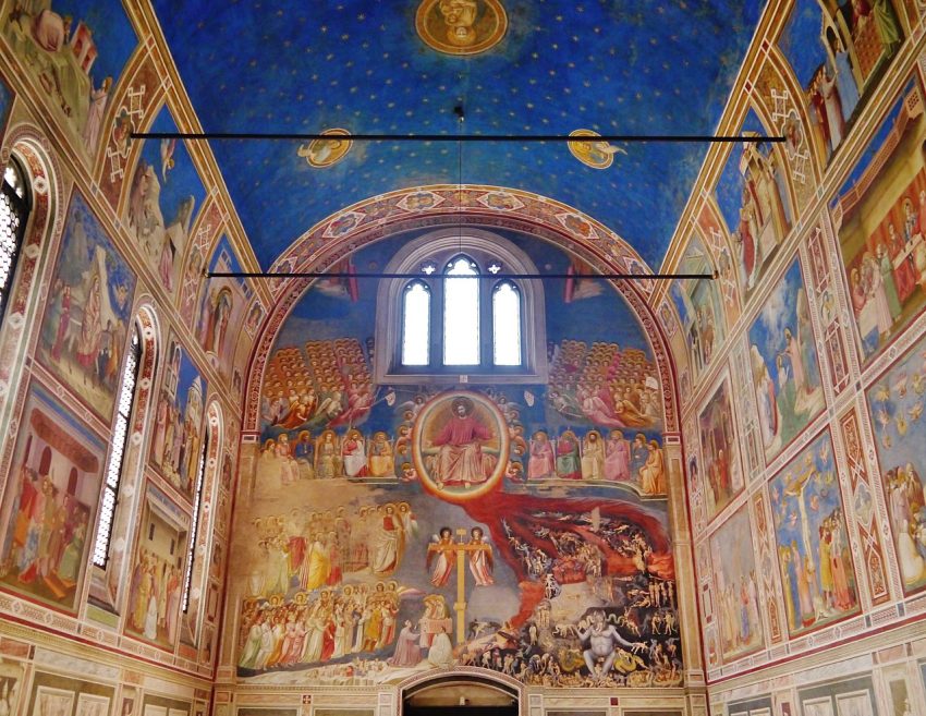
Cone out of the Musei Civici di Padova and turn left you will see the Cappella degli Scrovegni backing onto the Roman Arena.
The Scrovegni Chapel, located in Padua, was adorned with an array of magnificent frescoes by the renowned artist Giotto in the early years of the 14th century. This remarkable transformation of the chapel was commissioned by the local moneylender, Enrico Scrovegni.
Giotto’s position as one of the most significant painters in history is indisputable, as he played a pivotal role in redefining the boundaries of pictorial expression. His influence on the art world is immeasurable, casting a long and enduring shadow across the annals of art history. To discuss the history of art without acknowledging the profound impact and enduring legacy of Giotto would be incomplete.
Among Giotto’s many masterpieces, the fresco cycle in Padua’s Scrovegni Chapel stands as his crowning achievement. This breathtaking work of art is a testament to his unparalleled talent and artistic vision, and it remains a cherished treasure for all who have the privilege of experiencing it.
Cross back over Corso Guiseppe Garibaldi and walk along Via Giotto. Turn third left down Via del Carmine and when you get to the end turn left to get to Ponte Molino.
Ponte Molino is an ancient Roman bridge featuring five graceful arches. Its construction dates back to the years 30-40 AD, and it offers enchanting vistas of the Bacchiglione River. This bridge is among the few surviving Roman bridges in Padua and a rare example of an ancient bridge designed for the passage of both pedestrians and vehicles.
The bridge earned its current name, “Molino,” due to the presence of floating watermills operating adjacent to it from the 10th century until the late 19th century.
The road that traverses this bridge was historically Padua’s most important street, known as “Stra’ Maggiore.” It was watched over by the Torre di Ezzelino, an imposing tower constructed by a famous medieval tyrant. While the tower can still be seen at the far end of the bridge, your attention may also be captivated by another significant structure that stands beside Ponte Molino – the renowned Porta Molino.
Porta Molino, a substantial gate, was erected in the 13th century and formerly served as the most critical gate in Padua’s medieval defensive walls. Local legend has it that the gate’s height was such that Galileo Galilei used it as an observatory for his celestial observations.
Location: Ponte Molino, Via Dante Alighieri, Padua, Province of Padua, Italy | Hours: Accessible at all times as a public thoroughfare, though visiting during daylight is best for appreciating details and views. | Price: Free (public bridge with no admission charge).
Walk across Ponte Molino and down Via Dante Alighieri. When you reach Piazza dei Signori you will see the Torre dell’Orologio on your right.
The Torre dell’Orologio is a clock tower situated in Piazza Dei Signori, nestled between the Palazzo del Capitanio and the Palazzo dei Camerlenghi in Padua, Italy. It is also known as the astronomical clock of Padua. The tower’s construction commenced in 1426 and was completed around 1430. The tower was commissioned by Prince Ubertino de Carrara, a member of the Carrara clan in Padua, who served as the Lord of Padua from 1338 to 1345. Subsequently, it was expanded to accommodate the new clock, which was crafted in 1427. The clock itself was finished in 1434. In 1436, decorative elements were added to the clock’s dial, and a year later, the clock tower was inaugurated. At the tower’s base, the grand triumphal arch, designed by Giovanni Maria Falconetto, was incorporated in 1531.
The clock’s design and construction were overseen by Giovanni Dondi dell’Orologio, also known as Giovanni de’ Dondi, an Italian physician, astronomer, and mechanical engineer. Gian Petro Dalle Caldiere provided assistance during the process. The clock’s design features references to the zodiac. However, the original clock did not include the Libra sign, as in the pre-Roman system, Scorpio and Libra were considered one zodiac sign.
The clock’s dial portrays the Earth at its centre, displaying the phases of the Moon, days, months, and the zodiac signs. Today, the clock is accessible to the public, with a group of volunteers known as Salvalarte ensuring that such sites remain open for public enjoyment. This group is affiliated with a nationwide environmental association.
Walk past the Torre dell’Orologio along Via Monte di Pietà until you reach the Piazza Duomo.
Although the interior of the Duomo is quite simple, it is worth to visit this beautiful renaissance style church. There is separate entry to the baptistry so you do not need to go in via the cathedral, which costs 3 euros. The 12 century baptistry of the Duomo contains one of the most complete medieval fresco cycles to survive in Italy.
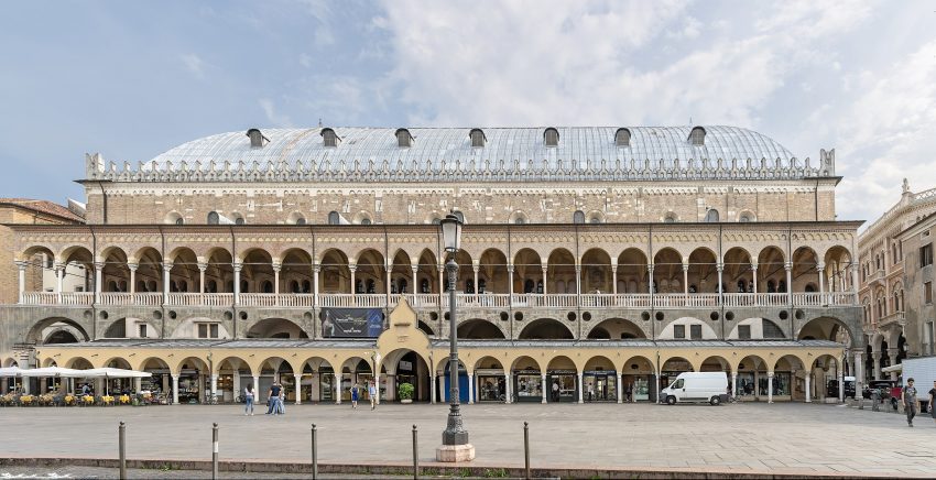
Either return to the Piazza dei Signori and walk past the Chiesa di San Clemente or walk down Via Daniele Manin to reach the Palazzo della Ragione.
It is worth visiting Palazzo Della Ragione and you should make time to go inside to see the frescoes. It is a stunning medieval town hall that was built in the 13th century. There are three floors, the underground has Roman ruins but is not always accessible to the public. Secondly, the ground floor is a wonderful place to get something to eat because it is full of cafes and then finally the top floor is where you will find the frescoes.
Head south down Via Roma to return to Prato della Valle.
This website uses affiliate links which earn a small commission at no additional cost to you.
Verona, a UNESCO World Heritage city in Italy's Veneto region, is renowned for its rich history, stunning architecture, and romantic charm. Famed as the setting of Shakespeare's “Romeo and Juliet,” Verona offers a captivating blend of ancient Roman structures, medieval buildings, and vibrant piazzas. Exploring Verona on foot allows visitors to fully immerse themselves in its enchanting atmosphere and historical significance.
Apart from “Romeo and Juliet” there is also another, lesser-known play by Shakespeare set in Verona, called “The Two Gentlemen of Verona”. Whilst there's no evidence that the bard had ever set foot in Italy, let alone in this town, Verona's presence in his work has inspired massive tourism here ever since - primarily to the 13th-century Juliet House with a tiny balcony upon which she supposedly once stood.
Whether you're tracing Roman roads or leaning over Juliet's balcony, Verona is a city that tells timeless stories through every stone and square.
By Plane:Verona is easily accessible by air, with Verona Villafranca Airport (also known as Valerio Catullo Airport) serving as the main gateway for travelers. Located just about 12 kilometers southwest of the city center, the airport handles a good number of international and domestic flights, making it convenient for visitors coming from various parts of Europe and beyond. From the airport, you can reach the city center quickly by shuttle bus, taxi, or rental car, usually within 15 to 20 minutes, allowing you to start your Verona adventure without hassle. For the best deals and a seamless booking experience, check out these flights to Verona on Booking.com.
By Train:Verona Porta Nuova is the city's main railway station, well connected to cities like Milan, Venice, and Florence. From the station, it's a 15-20 minute walk to the historic centre. Use Omnio to easily compare schedules, book train tickets, and find the best prices all in one place for a hassle-free journey across Italy.
By Car:Verona is easily accessible via the A4 and A22 motorways. If arriving by car – avoid the historic centre or you may well be fined. Try parking at Parcheggio Porta Palio – free parking and only 10-15 minutes to the main centre. If they are full there are more car parks if you head towards Porta Nuova (continue on outside the city walls.) Central parking is available at Parking Cittadella or Parking Arena. If you are looking to rent a car in Italy I recommend having a look at Discover Cars, first, as they compare prices and review multiple car rental agencies for you.
Where to Stay in Verona
To make the most of visiting Verona and exploring this walking tour, it's best to consider staying overnight near the city center. This area places you within easy walking distance of the main attractions, charming streets, and vibrant piazzas. Staying here means you can soak up Verona's romantic atmosphere and historic beauty without needing to rely on transport.
The historic center, around Piazza delle Erbe and Piazza Bra, is perfect for those who want to be in the heart of the action. Here, you can find elegant hotels like Due Torri Hotel, which offers a mix of luxury and tradition just steps from Juliet’s House. Another excellent choice is Hotel Accademia, blending comfort with classic Verona style, ideal for a relaxing stay after a day of walking. For travelers who appreciate boutique charm, Hotel Milano & Spa sits right in the pedestrian shopping district, offering modern amenities and a rooftop terrace with stunning views. Lastly, Antica Porta Leona & SPA offers a cozy, intimate experience close to the Roman Arena and the picturesque riverbank.
If you prefer a quieter vibe while still being near the city's main sites, the area around the Adige River and Castelvecchio is a great option. It combines beautiful views with easy access to the walking route, while also offering some peaceful spots to unwind in the evening. The charm of staying near this area is the mix of historic streets and scenic riverwalks, perfect for a relaxed Verona experience.
For those on a budget but still wanting to be central, the district near Verona Porta Nuova train station offers practical convenience with quick access to the historic core. While a bit further out, it's still a manageable walk or short tram ride away from the tour's starting points. Here you can find comfortable stays that keep you connected to the city without breaking the bank.
A Brief History of Verona
Verona's history spans over two millennia, beginning as a Roman settlement in the 1st century BC. The city flourished under Roman rule, evident in landmarks like the Arena di Verona, a remarkably preserved amphitheatre still in use today. Throughout the Middle Ages and Renaissance, Verona became a cultural and political centre, with the ruling Scaliger family leaving a lasting architectural legacy.
Its strategic location and rich heritage made Verona a crossroads of art, faith, and trade-and today it remains one of northern Italy's most picturesque cities.
Guided or Self-Guided Tour of Verona?
Verona’s compact layout makes it ideal for self-guided discovery, but for deeper insight into its layered past, consider a guided experience. The Verona Guided Small Group Walking Tour of the City of Love offers a two-hour journey through the city’s most iconic sites. With a knowledgeable guide, you’ll explore Roman ruins, medieval towers, and hidden corners while learning about Verona’s cultural heritage and romantic legacy.
Should you get the Verona Card?
It is worth deciding at this point if you are going to purchase the Verona 24-hour city pass (€20). Here is a quick breakdown of costs for paying separately to visit the following attractions.
Arena di Verona - €10 Castelvecchio Museum - €6 Lamberti Tower - €6 Juliet’s House - €6 Juliet’s tomb - €4.5 Basilica di Santa Anastasia - €3 Cathedral Complex - €3 Total without the card - €38.5
You can buy the card at the city tourist office (from the square walk along the road with the city walls to your right and the Arena and the Barbieri Palace (Verona Town Hall) on your left) or get hold of it online before your trip on sites such as GetYourGuide.
If you are arriving later in the day and were planning to see the outside of the Arena, the courtyard of Juliet’s House, to see the balcony, Lamberti Tower (€6), Teatro Romano (€4.50) and Castelvecchio Museum (€6).
Your Walking Tour of Verona
This guide highlights Verona’s key attractions, but depending on your pace and interest, you might linger longer in a quiet courtyard, visit more Roman ruins, or unwind with aperitivo in the golden evening light.
1. Piazza Brà (Verona)
Piazza Bra verona
CC BY-SA 2.0 / Son of Groucho
The Bra Square is the largest city square in Verona. It is the location of Verona Amphitheater, City Hall, Palace of Gran Guardia, and many other historical buildings. The square is surrendered by many cafes and restaurants. A statue of Victor Emanuel II on horseback, the balcony of the Honori Palace where one of Italy’s founding fathers Garibaldi gave his famous speech “Rome or Death”, and stone carvings of saints are just a few of the sites you will see here.
Located on Piazza Bra, this Roman amphitheatre can seat up to 22,000 people and was built in 30 AD. It is home to the Verona Opera season each summer. The arena is known for its superb acoustics. Over 500,000 people visit this place each year.
Obviously one of the most iconic places to see in Verona. However after reading the reviews on trip advisor I did query whether it is worth the visit. Basically it feels like a music arena not a trip to 2000 years into the past! (If you want Roman remains that don’t miss out on Verona’s Roman Theatre & Museum, at the end of this itinerary. ) My take on it is, if you have the Verona Pass, you don’t queue and you aren’t paying any extra to enter, then go for it. Pop in, if you are bored, leave and head straight to the Museo di Castelvecchio (Old Castle Museum), but at least when someone back home asks you if you have the Verona Arena you can look them in the sys and can say yes! If you don’t have the Verona pass, and you are facing a €10 entrance and a 20 minute wait, then I would say, the best views are from the outside and head on.
The House of Juliet, is a 13th-century structure situated on the remains of a Roman insula building on the Via Capello. It is located near well-known Juliet’s Tomb.
Although many dispute whether or not Romeo and Juliet actually existed, the house remains a popular attraction that thousands of tourists visit each year. In fact, the house was formerly owned by the Capello family. Many guests write notes on the wall and the doors of the courtyard. From the balcony, one can even imagine ill-fated lovers talking to each other.
The dwelling contains a museum that displays frescoes, paintings, and artwork from the 16th and 17th century. One treat not to be missed is the bronze statue of Juliet. It is said that good luck will come to those who rub the right breast of the sculpture.
Entrance into the courtyard is free, but entry into the house is not. While the house tour is pretty basic, you can upgrade your ticket to include the tomb as the grounds are lovely and have some nice frescoes.
Location: Casa di Giulietta, Via Cappello, Verona, VR, Italy | Hours: Tuesday – Sunday: 09:00–19:00.
Closed on Monday, 25 December & 1 January.
Last entry (house museum): 18:00.
| Price: €12 (standard ticket; reductions available and under 18s free). | Website
Traveling to a country with a different currency? Avoid ATM transaction fees and pay in local currency with a Wise Card. Having used it for over 5 years, we've saved loads on fees!
Market Square was originally the site of a Roman forum, or square, which hosted exciting chariot races. It is also known as the square of herbs. Historically, various aromatic spices, herbs, coffee beans, and textiles were shipped to Venice and imported to Verona’s Market Square.
In keeping with tradition, the square hosts a market from Monday to Saturday. This market features souvenir vendors as well as farm-fresh produce and flowers.
The Lamberti Tower is an ancient tower in the Market Square. Construction on the tower began in 1172. The tower underwent restoration after a 1403 lightning strike. Visitors can see the different restoration work over the centuries by noticing different materials. For example, the marble areas were added in 1779. The clock was also added during the 1779 renovation.
The Lamberti Tower has two bells. The largest bell named Rengo is used to call residents to arms or call a city council. The Marangona bell signals fires, hourly chimes, and work times.
The tower stands 84 meters high. Visitors can book tickets in advance, take the elevator, or walk the 368 stairs to the top of the tower. The elevator is transparent so visitors can admire the internal architecture. At the top of the tower, visitors can enjoy panoramic views from the terrace. At night, the terrace is available for events.
The Lords Square is packed with gorgeous architecture and is a fabulous place to soak up the history and culture of Verona.
This historic square has a strong connection with William Shakespear’s Romeo and Juliet, set in Verona. The Town Hall provided the setting where Bartolomeo della Scala banished Romeo and sentenced him to exile in Mantua.
The Scaligeri Tombs are known as the location of Juliet’s staged death. The Scaligeri Tombs are a group of five Gothic monuments. They were built to celebrate the della Scala family, 13th and 14th-century rulers of Verona.
Location: Scaliger Tombs, Via Santa Maria Antica, Verona, VR, Italy | Hours: Friday – Sunday: 10:00–13:00 & 14:00–17:00.
Closed on Monday – Thursday. | Price: Free (courtyard entry is reserved for holders of a same-day Civic Museums ticket or a VeronaCard). | Website
The Construction of the Sant’Anastasia Church began in 1280 and was completed in 1400. The church was named after a temple that once stood on the site. The Sant’Anastasia Church is the largest in Verona. The facade has three vertical brick sections and a simple rose window. A gorgeous facade panel shows St. Peter of Verona.
Location: Sant’Anastasia, Piazza S.Anastasia, Verona, VR, Italy | Hours: (Summer) March – October: Monday – Saturday: 09:30–18:00. Sunday & public holidays: 13:00–18:00.
(Winter) November – February: Monday – Saturday: 10:00–17:00. Sunday & public holidays: 13:00–17:30. | Price: €4.00. | Website
The Ponte Pietra, or Stone Bridge, is the oldest bridge in Verona. It was completed in 100 BC by the Romans. The Ponte Pietra crosses the Adige River. In Roman times, the Via Postumia connecting Genoa to Aquileia passed over the bridge.
Well-known for its many concerts, music performances, and ballets, the Roman Theatre seats 25,000 people. Having actually been built during the 1st century AD, it is one of the oldest monuments in Verona.
For centuries, the ruins of the theater were buried underneath residences constructed on the property. In 1834, a Veronese named Andrea Monga bought all the houses built on the property, then demolished them and began the renovation process. It is because of his efforts that the structure was saved.
In 1904, the city purchased the property and continued renovations until the 1970s. Although most of the structure was lost due to the ravages of time, the cavea, tier of seats, several arches of loggias, and parts of the stage and the old theater were recovered. One can truly take a step back in time when visiting the Roman Theatre.
The theater is well-known for its Shakespeare Festival held from June to August each year. Jazz concerts in May, plays in June, and ballets in August are just some of the treats to enjoy. Admission is free on the first Sunday of each month.
11. Piazzale Castel San Pietro (San Pietro Fortress)
Vista verso Caste San Pietro
CC BY-SA 4.0 / ApXc
This medieval fortress is set high on a hilltop above Verona. The hilltop location was chosen as the ideal location to protect the city against intruders. The Romans used this hilltop as a defensive position.
During Roman times, the hill was known as Monte Gallo, or Rooster Mountain. The Romans also revered this location as a religious site and built a temple and theater here.
The hill was later named Colle San Pietro when a Medieval church dedicated to St. Peter was built on the site. The area was next fortified with battlements typical of medieval fortresses. Between the 14th and 15th centuries, the Castello Visconteo (the Castel of the Viscount) was built.
In 1801, the Napoleanic army destroyed most of the buildings on this historic site. Later, Austrian soldiers arrived and destroyed St. Peter’s Church. The Austrians built barracks that are still in place.
Today, visitors can climb the switchback stone steps to the top or take a funicular cable car to the top of the hill. This hilltop location is a beautiful place to view the city of Verona, take pictures, and watch the sunset. There’s also a restaurant at the top of the hill so you can relax and enjoy a meal or drinks.
Location: Castel San Pietro, Piazzale Castel San Pietro, Verona, VR, Italy | Hours: (Summer) 01 April – 31 October; Daily: 10:00–21:00.
(Winter) 01 November – 31 March; Daily: 10:00–17:00. | Price: Free to access the panoramic terrace on foot; Funicular €3 roundtrip / €2 one way. | Website
The Verona Cathedral is dedicated to the Blessed Virgin Mary. It was built after the previous churches on this site were destroyed. The Romanesque style Verona Cathedral was consecrated in 1187. The west facade features a double porch, Lombard bands, and small pinnacles.
Location: Verona Cathedral, Piazza Duomo, Verona, VR, Italy | Hours: (Summer) 01 March – 30 June; 01 September – 31 October: Monday – Friday: 11:00–17:30. Saturday & pre-holidays: 11:00–15:30. Sunday & religious holidays: 13:30–17:30. 01 July – 31 August: Monday – Friday: 10:30–17:30. Saturday & pre-holidays: 10:30–15:30. Sunday & religious holidays: 13:30–17:30.
(Winter) 01 November – 28 February: Monday – Friday: 11:00–17:00. Saturday & pre-holidays: 11:00–15:30. Sunday & religious holidays: 13:30–17:30. | Price: €4 (single church); €8 cumulative ticket for the four historic churches. | Website
The Borsari Gate is an ancient Roman gate that was built in the first century AD. It was previously called the Lovia Gate and then the San Zeno Gate before receiving its current name. The original structure was brick and contained an inner court. It was rebuilt in 265 and given a limestone facade. The upper part of the gate features 12 arched windows.
Arco dei Gavi is a monument in Verona, located just outside the walls of the ancient Roman city. The arch was built in the 1st century to celebrate the gens Gavia, an important Roman family of Verona.
The Old Castle Museum is a museum located in the eponymous medieval castle. The castle was built between 1354 and 1356 to protect the family of Lord of Verona from enemies and to give them ample time to escape. The palace was used to house military weapons and munitions in the 1400s and eventually became the seat of the Venetian military academy in the 1700s. In 1925, it was made a museum.
Scaligero Bridge is a three-arch bridge that spans the Adige River. It was built in 1375 for the Scaliger family who wanted to use the bridge as an escape route from the Old Castle to the river.
Self-Guided Walking Tour of Exeter, England (2026)
Exeter Guildhall
CC BY-SA 2.0 / Franzfoto
This website uses affiliate links which earn a small commission at no additional cost to you.
Exeter, one of the oldest cities in England, is a place where layers of history sit side by side with a lively, modern atmosphere. Founded by the Romans as Isca Dumnoniorum, its ancient roots are still visible in the remnants of the city walls and the underground passages that once supplied the medieval city with fresh water. At the heart of Exeter lies the magnificent Cathedral, a masterpiece of Gothic architecture that dominates Cathedral Green and serves as the perfect starting point for exploring the city on foot.
A walking tour of Exeter allows you to uncover its hidden corners and stories. From the historic quayside, once a bustling center of trade and commerce, to the charming cobbled streets of the old town, the city offers an intimate experience best enjoyed at a slower pace. Along the way, you'll encounter medieval churches, Tudor houses, and Georgian facades, all reflecting Exeter's long and varied past.
At the same time, Exeter is a vibrant university city with a youthful energy, excellent shopping, and a thriving food scene. Cafés spill out onto squares, independent shops line narrow lanes like Gandy Street, and contemporary art and performance venues add a modern flair to the historic setting. A walking tour weaves these different aspects together, offering visitors the chance to truly appreciate the city's unique blend of ancient heritage and contemporary life.
By Plane:Exeter is served by Exeter International Airport, located just a short drive from the city center, with flights connecting to several UK and European destinations. From the airport, you can easily reach the city by taxi, bus, or car hire in under 20 minutes. For the best deals and a seamless booking experience, check out these flights to Exeter on Booking.com.
By Train:Exeter is well connected by rail with direct services from London, Bristol, and the southwest. The Exeter St Davids station is a short walk or bus ride to the city centre.
To make the most of visiting Exeter and this walking tour then you should consider staying overnight at the centre, where the city's historic sights, shops, and cafés are all within easy reach. In the heart of the city, near Cathedral Green, Southernhay House Hotel offers a boutique experience in a charming Georgian building, ideal for exploring the old town. Another excellent choice is Hotel du Vin & Bistro Exeter, which combines modern comforts with historic character, placing you just steps from the cathedral and city center. For those seeking a classic hotel experience, The Royal Clarence Hotel provides elegant rooms and easy access to Exeter’s key landmarks.
Closer to the quayside and the river, Mercure Exeter Southgate Hotel offers modern accommodations with convenient access to the historic Exeter Quay and nearby shopping streets. The Devon Hotel is another good option, slightly further out but within walking distance, featuring comfortable rooms and a welcoming atmosphere. For a more intimate stay, Jury’s Inn Exeter places you close to the railway station and city center, making it ideal for travelers arriving by train.
A Brief History of Exeter
Exeter's history stretches back over two millennia, beginning as the Roman settlement of Isca Dumnoniorum around AD 55. The Romans established the city as a military and administrative center, building the original Exeter city walls, sections of which can still be seen today, along with the Old Exe Bridge, which facilitated trade across the River Exe. After the Roman withdrawal, Exeter continued to thrive under Anglo-Saxon rule, with fortifications such as Athelstan's Tower and the Norman Gatehouse later reinforcing the city during the medieval period.
During the Middle Ages, Exeter grew as a commercial and religious center. The impressive Exeter Cathedral, begun in the 12th century and completed in the 14th century, became the spiritual heart of the city, showcasing remarkable Gothic architecture. Exeter's prosperity is also reflected in its civic buildings, including Tuckers Hall, home to one of the city's medieval guilds, and the Guildhall and Merchant Houses, where merchants conducted trade that fueled the local economy. St Nicholas Priory, founded in the 11th century, remains one of the oldest surviving religious structures, offering a glimpse into monastic life in medieval Exeter.
The city continued to develop during the industrial era, expanding its infrastructure to support trade and manufacturing. The Exeter Ship Canal, constructed in the 16th century, allowed ships to bypass the River Exe's treacherous estuary and reach the city, while the Customs House and Cricklepit Mill highlight Exeter's commercial and milling history. Public spaces such as Northernhay Gardens, established in the 17th century, and cultural institutions like the Royal Albert Memorial Museum and Art Gallery, opened in the 19th century, illustrate the city's evolving civic life. These landmarks together chart Exeter's journey from a Roman fort to a thriving medieval city and into a modern urban center, rich in history and architecture.
Guided or Self-Guided Tour of Exeter?
While Exeter’s city centre is compact and easy to navigate, an interactive experience adds a unique twist. The Exeter City Walking Tour & Exploration Game transforms the streets into an urban puzzle. This self-guided adventure combines storytelling and challenges that lead you through historic landmarks and hidden gems.
Your Walking Tour of Exeter
The first part of our tour takes us through Exeter's historic past as a wool town. By the early 1700s Exeter was a very wealthy city, thanks to wool. Exeter's prominence in the cloth industry was due to its proximity to spinners and weavers throughout Devon, and the fact that cloth was finished on Exe Island. The cloth was loaded onto ships at Exeter Quay and exported to France, Spain, Holland and Portugal. Business thrived until the effects of the Napoleonic Wars and the dominance of the mechanised mills of the north of England led to the decline of the woollen cloth trade in Exeter. We will then explore the old town to explore its medieval past. The Middle Ages were a period of rapid growth for Exeter. It became the religious, commercial, and administrative centre for the region. Throughout the period following the Norman Conquest in 1066 until the reign of Henry Tudor in 1485 (Henry VII), a complex relationship between the Crown, Cathedral and City developed.
1. Exeter Ship Canal
The canal basin at Exeter
CC BY-SA 2.0 / Bill Boaden
Park at Okehampton Street Car Park, EX4 1DY or Okehampton Street Car Park, EX4 1DY. Head tho the nearby River Exe and turn right. There is a pleasant reverside walk that you can start on. half a mile later you will be on Exeter Quayside, although a modern development its full of bars and restaurants.
This is the start of the Exeter Ship Canal. It first opened to shipping in 1566 and was the first canal to be built in Britain since Roman times. It was also the first canal in England to use the pound lock.
Here is a complete selection of hotel options in Exeter. Feel free to review each one and choose the stay that best suits your needs.
2. Customs House
Old Custom House Exeter
CC BY-SA 4.0 / Herbythyme
Cross over the Cricklepit Bridge, built in 1988 to link the quayside with Haven Banks. Or if you are in the Summer and feeling brave you can cross the Butts Ferry, a hand-operated pedestrian cable ferry. After using the bridge, bear left to reach the Visitor centre at the customs house. If you used the ferry head left.
The Quay House was re-built in 1680-1 at the height of Exeter’s woollen cloth industry. The building was used to store cloth and other goods before they were loaded and transported down the canal. It also had an overhanging roof, which enabled cargos to load and unload out of the rain.
Today the history and development of Exeter’s Quayside is brought to life with lively displays, illustrations and artefacts. There is also the opportunity to see “Exeter – 2,000 years of history,” an exciting audio-visual presentation highlighting Exeter’s history from Roman times to the present day. The Quay House Visitor Centre provides tourist information, Quayside treasure hunts, an accommodation booking service and a gift shop selling local pottery, replica maps and a wide range of local interest books.
Just beyond along the canal are the olds warehouses the which today are used by crafts and antiques shops to sell their wares and places to eat and drink. After the decline of the woollen cloth industry this area of the Quay was still busy with the storage and transportation of grain, wine and oil.
Traveling to a country with a different currency? Avoid ATM transaction fees and pay in local currency with a Wise Card. Having used it for over 5 years, we've saved loads on fees!
3. Cricklepit Mill
Exeter Cricklepit Mill
CC BY-SA 2.0 / Martin Bodman
Head back along commercial street, with the canal on your left. lookout for the Bishop Blaize Pub, behind it is Cricklepit Mill.
This area you are now in was called Exe Island, it was once the very heart of the Devon cloth industry packed with mills, fulling stocks, cloth drying sheds and racks. You can imagine the noisy activity of workers with heavy hammers pounding the newly dyed cloth. The fulling mills were powered by water via man-made channels called ‘leats’.
Cricklepit Mill was one of many in Exeter, including three on the Quay, but most have gone or are in a bad state of repair. Cricklepit Mill now offers a small visitor centre and wildlife garden where we run a range of events and activities for the general public.
| Hours: The garden is open to the public Monday to Friday 9am - 5pm (except bank holidays). | Price: Free | Website
At the end of commercial street take the subway on the left of the road and you will come out in a park and see the Old Exe Bridge.
This is where the first bridge across the River Exe was built in 1200. During the boom years of the woollen cloth trade, packhorses and horse drawn carts trying to get in and out of town would regularly get held up on the narrow bridge.
You need to head to the raised New Bridge Street. There are step on the other side of it, climb the steps and head left up Fore Street.
Members of the Cloth Workers Guild met here to make decisions about their trade. They would discuss such things as quality standards and apprenticeships. You can see the tools of their trade in the ironwork on the gate.
Location: 140 Fore Street, Exeter, Devon, EX4 3AN | Hours: Tuckers Hall will be open every Thursday and Saturday mornings every week. Opening hours will be from 10:30 until 13:00 on all days.
Carry on up fore street to Mint Lane, at the end of which is St Nicholas Priory.
Part of this historic building was home to two of the city’s most prominent wool merchants. The Priory was built almost a thousand years ago as a Benedictine monastery and was partly destroyed during the Dissolution of the Monasteries in 1536.
Retrace your steps to fore Street and continue along it. It turns into high Street and the Guildhall is on your left.
For over 800 years the Mayor and Council have regulated the affairs of Exeter from the impressive Guildhall. The homes, shops and offices of wealthy merchants were also built in this area. You can
still see the beautiful timber fronts.
Location: 203 High Street, Exeter, Devon | Hours: The historic Guildhall remains very much a working building and is in frequent use for Mayoral functions, Council Meetings, Private hire, Weddings, etc. See website for more details.
| Website
Exeter City War Memorial Northernhay Gardens in springtime
CC BY-SA 4.0 / Smalljim
Continue along the High street until you reach castle street. Dont miss out on the information panels on you left. Turn right onto Bailey Street, turn left into Northernhay Place then up the hill into Northernhay Gardens.
The site of Northernhay Gardens was quarried in Roman times for stone from which to build the adjacent city walls. Walking through the gardens is a good way of seeing the walls.
When in the park follow the higher path by the wall until you arrive just below Athelstan’s Tower (opposite the bandstand).
King Athelstan also built a castle on the highest ground inside the wall, on the Red Mount, now known as the Norman, Rougemont Castle. It is thought that the only part of his castle to survive is a part of the ruins known as “Athelstan’s Tower”.
Walk through Athelstan’s Tower through Rougemont gardens to see the Norman Gatehouse.
Although not strictly part of the wall, the castle was an important part of the city’s defences. Built in 1068 following the Norman siege of Exeter, it established a foothold of control for the Normans over the previously rebellious citizens of Exeter. This gatehouse is the oldest standing castle building in Britain.
Walk back through the Rougemont gardens, and pass through another gate in the walls. Note the herringbone structure of the walls. Turn left and continue through the park until you reach Queens Street. Turn left along it and RAMM is on your left.
The displays in the museum reveal Devon and Exeter’s rich history and global connections. Exotic animals, birds and insects delight children and the World Cultures galleries display stunning items from all over the world.
walk back the way you came, then cross Queen Street onto Northernhay Street, after 50 metres turn into Maddocks Row. At the end of Maddocks Row turn right into Paul Street and proceed to the traffic lights at the south end of the Iron Bridge. You are now at the site of The North Gate.
North Gate: This was the site of one of the smallest of the city’s four main gates. It was burnt down during the Perkin Warbeck Rebellion of 1497 and also damaged during the Prayer Book Rebellion of 1549.
Cross the traffic lights and go straight ahead into Bartholomew Street East. Keeping the railings on your right, walk straight down the path to Bartholomew Terrace.
Snayle Tower: On the corner of Bartholomew Terrace in front of you once stood a large semi-circular tower that dominated the defences to the west of the city. It offered an excellent observation point for the many sieges of the city particularly during the English Civil War.
Continue to the end of Bartholomew Street West. Cross Fore Street, walking down the hill to the end of West Street.
West Gate: This gate was the main entrance to the city from Plymouth and Cornwall and was a particularly busy place at the height of the woollen cloth trade.
Cross Western Way at the pedestrian crossing. Turn left and walk uphill to the first turning on your right (Lower Coombe Street) and proceed onto cobbled Quay Hill, at the bottom you will be at Water Gate.
Water Gate: This gate was added to the city wall circuit for commercial rather than defensive reasons. During the 16th and 17th centuries this area was involved in the woollen cloth industry, be it finishing the cloth on Exe Island or exporting the cloth from the Quay.
Continue on the footpath up the hill to Western Way.From here either cross Western Way via the Yaroslavl Bridge, or to your right over the pedestrian crossing. The next board is located on the other side of South Street. Here you will find out about the South Gate.
From here either cross Western Way via the Yaroslavl Bridge, or to your right over the pedestrian crossing. The next board is located on the other side of South Street. Here you will find out about the East Gate.
South Gate: This was the most impressive of all the city gates. This stretch of wall was very vulnerable from attack, so a number of smaller towers were built.
Follow the footpath alongside the city wall to Cathedral Close, turn right on to Southernhay. At Southernhay turn left then continue behind Broadwalk House to discover more about the East Gate.
East Gate: Being the principal entry point to the city, this gate played a vital defensive role during the many sieges of Exeter, especially during the Perkin Warbeck rebellion.
From the end of the city wall head back to the High Street. You will pass on your left St. Stephen’s Church, which dates from the 11th Century.
The Cathedral is the jewel in Exeter’s crown. Exeter became a major ecclesiastic centre in the Middle Ages, not only was there a Cathedral, but within the city there were 32 parish churches, and around the area there were 7 monastic houses.
The cathedral area has been used as a place of worship since the 4th Century and eventually a Saxon Abbey was built. The Abbey became a Cathedral in 1050. From 1114 a new Cathedral was constructed, and in the 13th and 14th centuries the Cathedral was rebuilt in the Decorated Gothic architectural style.
If you walk anti clockwise around the cathedral you will come to St Petrock’s (Exeter) Ltd, and the Gates to the Close For over 500 years entry to the Cathedral Precinct would have been controlled by seven gates. The gates were erected following the murder of a member of the Cathedral clergy.
Isle of Skye Castles You Need to Visit 2026: Map & Highlights
Caisteal Maol
CC BY-SA 2.0 / mhx
This website uses affiliate links which earn a small commission at no additional cost to you.
There are several things to see and do on Skye, but visiting the Isle of Skye castles may be one of the best Isle of Skye activities. The seven castles range from opulent stately homes to ruined fortresses, however they all possess a rich medieval history, prominent locations with rugged wild Scottish backdrops. We have also included two bonas castles for you to see!
Two main clans ruled the Isle of Skye for centuries, and Clan MacLeod & Clan MacDonald. Both have castles on the island. Of the smaller clans, the most notable is Clan MacKinnons.
1. Caisteal Maol
Caisteal Maol
CC BY-SA 2.0 / mhx
Located near the Skye Bridge, commanding the strait of Kyle Akin between the Isle of Skye and mainland Scotland, Castle Maol (also known as Caisteal Moil) was originally fortified before the tenth century. Owned by Clan Mackinnon throughout its long history it was rebuilt in the late-fifteenth century in the form of a Tower House.
Here is a complete selection of hotel options in Isle of Skye. Feel free to review each one and choose the stay that best suits your needs.
2. Knock Castle
Knock Castle Isle of Skye
CC BY-SA 4.0 / Nealwhitehousepiper
Knock Castle, which is also known as Caisteal Uaine or Castle Camus, was built by the MacLeod clan in the late thirteenth century in order to control the Sleat peninsula. Around 1435 it was seized by the MacDonalds and they substantially rebuilt the structure including adding the Keep and enhancing the fortifications which enabled it to resist an attempt by the MacLeods to retake it.
Traveling to a country with a different currency? Avoid ATM transaction fees and pay in local currency with a Wise Card. Having used it for over 5 years, we've saved loads on fees!
3. Armadale Castle
Armadale Castle
CC BY-SA 4.0 / Mike Peel
Armadale Castle is the 19th century seat of the Clan MacDonalds in the south of Skye. The castle was built in 1815 and extended in 1855, but the MacDonald family moved out in 1925 and then the castle suffered a major fire and became the ruin that you see today. It was purchased by Clan Donald Lands Trust that started renovating it and turned it into a museum. You can explore 40 acres of beautiful woodland walks and enjoy spectacular views over the sea to the majestic mountains of Knoydart.
You can also learn about Highland history in their fascinating Museum of the Isles, Skye’s only Museums Galleries Scotland accredited museum!
| Hours: Gardens open Wednesday – Sunday, 9.30 – 5.30, to end October. Last entrance 5pm. | Price: Adult: £8.00 Concessions: £7.00 (60 and over, students with student card, disabled people) Child under 5: Free Child 5-15: £5.00 | Website
Located in the southern part of the island, near the town of Tokavaig this is one of several fortifications built by the MacLeod clan on the Isle of Skye. Dunscaith Castle occupies a large rock overlooking Loch Eishort on the western side of the Sleat peninsula. Also known as Dùn Sgàthaich, it was taken over by the MacDonalds of Skye but was recaptured by the MacLeods in 1495.
Dunvegan Castle can be found on the Eastern shore of the Isle of Skye overlooking Loch Dunvegan. Dunvegan Castle is by far the most famous castle on the Isle of Skye. Probably occupying the site of a much earlier fortification, Dunvegan Castle was built in the thirteenth century by the MacLeod clan as part of their efforts to secure control of the Isle of Skye. It was substantially rebuilt in the eighteenth and nineteenth centuries creating the structure seen today. It is the oldest continuously inhabited castle in Scotland.
Located near Uig, Caisteal Uisdean is another ruined castle on Skye. Caisteal Uisdean was built by Hugh MacDonald who was the son of a deposed clan chief. Hugh had become an outlaw but was pardoned and built the castle around 1589 to serve as his new residence. However, he continued to seek revenge against those who had killed his father and, when he attempted to incite a rebellion, he was murdered.
Duntulm Castle on the northern coast of the Isle of Skye, on the Trotternish peninsula. Perched high on the cliffs the castle was hotly contested between the Macleod and Macdonald Clans. Centuries of warfare and feuding were ended by a settlement in favour of the latter but in 1730 the castle was abandoned for a more comfortable residence elsewhere.
Castle Ewen is a natural landmark located in Fairy Glen, in the northern part of the island. One of the hills of the glen still has its basalt topping intact which, from a distance, looks like a ruin and has been called Castle Ewan. It is possible to climb to the top where there is not much room, but does have wonderful views. In the low cliff behind Castle Ewan there is a very small cave where it has been said pressing coins into cracks in the rock will bring Good Luck.
Although on the mainland it would be remis of me not to mention the classic Eilean Donan Castle. The first castle was built in the 13th Century to protect the surrounding lands from Viking raiders. The island it was built on was called Saint Donan’s Isle, and its current name derives from its Gaelic name – Eilean Donan.
Over the centuries the castle expanded until 1719 when it was occupied by Spanish soldiers and blown up by the Royal Navy during the 1719 Jacobite Uprising. For nearly 200 years a neglected stump was all that was left of the castle sitting on its little island.
In 1911 John Macrae-Gilstrap bought the island and set to work rebuilding the castle. It took 20 years, but the result of his efforts is quite simply magical, providing one of Scotland’s most iconic sights and certainly one of the best castles in Scotland.
Location: Eilean Donan Castle, Dornie, Kyle of Lochalsh, UK | Hours: 1 February – 29 March 2025: Daily: 10:00–16:00;
30 March – 31 May 2025: Daily: 10:00–18:00;
1 June – 30 June 2025: Daily: 09:00–18:00;
1 July – 31 August 2025: Daily: 09:00–18:00;
1 September – 30 September 2025: Daily: 09:30–18:00;
1 October – 25 October 2025: Daily: 10:00–18:00;
26 October – 22 December 2025: Daily: 10:00–16:00.
Closed on 1, 5, 8, 14, 15, 16 and 27 November 2025. | Price: £12.00; Concessions (60+): £11.00; Children (5–15): £6.50; Under 5s: Free; Family (2 adults + 3 children 5–15): £35.00. | Website
This website uses affiliate links which earn a small commission at no additional cost to you.
Walking Tour Map
Preview map of the Isle of Skye Castles You Need to Visit: Map & Highlights route in Isle of Skye, showing 9 stops. Use the interactive map to zoom and tap markers.
This website uses affiliate links which earn a small commission at no additional cost to you.
Offering some of the best scenery on the Isle of Skye, the Trotternish Loop is a 50-mile circuit around the north of the island that simply cannot be missed. It connects many of the island's main attractions and also provides jaw-dropping scenery. Depending on the season and the direction in which you choose to drive the Trotternish Loop, the full journey should take around 2 hours.
1. Portree
Portree harbour front
CC BY-SA 4.0 / DeFacto
Skye’s capital, Portree, sits at the southern end of Trotternish on the banks of Loch Portree and is the obvious starting point for travelling around the Trotternish loop.
Portree is the largest village on the island and you can enjoy a hot breakfast and cup of tea or coffee to begin your day. There are a number of great local spots to choose from before you begin exploring, Portree is very small place so take a quick wander around to see what takes your fancy. You could also stop by the local shop to pick up any supplies or snacks you may need during the day. You may like to have a quick wander around the village, but don’t worry if you feel rushed for time as you will end up back in Portree later today.
Here is a complete selection of hotel options in Isle of Skye. Feel free to review each one and choose the stay that best suits your needs.
2. The Old Man of Storr
Old Man of Storr Scotland
CC BY-SA 2.0 / Sanshiro KUBOTA
You can’t come to the Isle of Skye and skip the Old Man of Storr! The Old Man of Storr is another iconic landmark on the Isle of Skye, and you can spot the famous giant pinnacle standing proudly as you drive around the Trotternish Peninsula and even from Portree on a good day. The hike to the base of the pinnacle takes around 1.5 – 2 hours and, while it’s a steep climb, it will give you spectacular views of the coast. Make sure you pack your hiking boots for this one as the ground can be very rocky and muddy along the way.
Traveling to a country with a different currency? Avoid ATM transaction fees and pay in local currency with a Wise Card. Having used it for over 5 years, we've saved loads on fees!
3. Lealt Gorge and Falls
Lower falls at Lealt
CC BY-SA 2.0 / John Allan
The Lealt Gorge and waterfalls are a hidden Gem of the peninsular – the waterfalls are beautiful and if you’re feeling adventurous (and it’s a clear, dry enough day) there’s a little footpath that goes down the hill to the water’s edge and the ruins of the old salmon bothy. Very cool and really gorgeous views of the sea one way and the waterfall the other way.
Rubha nam Bràithrean, or Brothers’ Point, is a short walking route to the furthest eastern point of the Trotternish peninsula. The views along the walk to Brother’s point are incredible. The trail is easy and the path includes a couple of steep, narrow sections on the way to Brother’s Point. You will pass by Scottish cottages and many sheep along the way.
Kilt Rock is a unique sight, and the perfect iconic Isle of Skye photo location! These steep cliffs located mid-way around the Trotternish Loop look strangely similar to a Scottish pleated kilt.
This quick stop won’t take long, as the carpark is located directly next to the viewpoint. Here you can also spot Mealt Falls tumbling over the edge of the rocks into the ocean below. No matter the weather this stop is always worth it.
Head down to Staffin Bay and the Dinosaur Museum, home to an internationally acclaimed collection of dinosaur fossils. They offer tours of the infamously hard to find Staffin dinosaur footprints.
Location: Ellishadder Staffin IV51 9JE | Hours: April - October
10:00am-5:00pm 7 days a week | Price: Adults: £4 Children: £2 Family Ticket: £10 | Website
Certainly one of the Isle of Skye’s most well-known and impressive landscapes, the Quiraing is a mythical looking mountain range formed by an ancient landslide. You will find these peculiar shapes and formations up a narrow single track road, just as you pass through the tiny village of Staffin.
You can choose to either take a short walk from the carpark and enjoy the views from here, or if you have more time you can hike the full loop which will take you around 3-4 hours.
Situated at the top of the Trotternish Loop lies Duntulm Castle. This haunting ruin sits atop a crumbling cliff and offers a commanding view northwest to the outer Hebrides. The castle draws thousands of visitors every year, partly because of its ideal position on the tourist loop and also because of the ghostly happenings that it has become famous for.
Flora MacDonald is celebrated as a heroine of the Jacobite rebellion of 1745. The memorial to Flora Macdonald is in the graveyard at Kilmuir in the north of Skye.
The Skye Museum of Island Life gives an insight into a way of life that was common on Skye and across the highlands and islands more widely at the close of the 1800s. It consists of a group, or township, of seven thatched cottages, four of which are furnished and equipped as they would have been at the time to illustrate different aspects of island life.
The Fairy Glen is a magical area of bizarre rock formations, conical hills, and small lochans. Great to have a walk around here and take in all the legendary stories especially on a sunny spring day. It’s about a 1.5 mile walk from the hotel to the prettiest areas of the glen.
In the glen you will find waterfalls and pretty pools surrounded by little hills. There’s also a small loch in the shape of Lochan Mor. You can climb the hills and Castle Ewen (a tall rocky outcrop) for a lovely view over the area.
This website uses affiliate links which earn a small commission at no additional cost to you.
Walking Tour Map
Preview map of the Exploring Skye’s Trotternish Peninsula: Map, Walks & Highlights route in Isle of Skye, showing 11 stops. Use the interactive map to zoom and tap markers.
This website uses affiliate links which earn a small commission at no additional cost to you.
Launched in 2014, North Coast 500 has quickly become the 'must do' road trip in Scotland and dubbed “Scotland's Route 66”. Although the roads, sites, and beauty have always existed in the Scottish Highlands, it wasn't until it was given a name that the route exploded in popularity! The route has been planned to take in some of Scotland's most spectacular scenery following the coastal roads that encompass the northern most part of the country. The route runs for more than 500 miles to and from Inverness, the capital of the highlands, and from there, you can either travel up the east coast or head to the west and travel up.
The route is best enjoyed at a slow pace, stopping to admire the views and villages along the way. The official beginning is Inverness Castle, but feel as it is a circular route you can join anywhere along its southern route. Most people will overnight in Inverness.
Route: Most people will head west out of Inverness along the A862 alongside the Beauly Firth. If you weather is great and you are keen to spend more time exploring on the Black Isle then you can head out on the A9 over the Kessock Bridge.
Beauly: Beauly’s name is thought to come from the words of Mary Queen of Scots when she visited in 1564 and commented ‘C’est un beau lieu’ (what a beautiful place). Set around a charming square with its wonderful floral displays, there are plenty of independently owned shops to browse in. The village is best known for Beauly Priory, or the Priory Church of the Blessed Virgin and John the Baptist, which was founded in 1230 by Valliscaulian monks. The Reformation in 1560 brought an end to its religious use and it is in ruins now, but it's maintained by Historic Scotland and worth a visit (free to visit). Beauly Priory was a location mentioned in the Outlander books by Diana Gabaldon.
Muir of Ord: The villageMuir of Ordwhich offers a golf course and a nearby whisky distillery. The Muir of Ord golf course is also the site of the Castle Hill Henge (also known as the Muir of Ord Fort) which may be a Neolithic or Bronze Age henge. If you want to see it, just stop in at the golf course and ask about it. The Glen Ord Distilery, which produces a popular single malt whisky, has a visitor centre which offers distillery tours and tastings.
Black Isle
The Black Isle is not an island at all – but rather a peninsula. It isn’t certain where it gets its name from, some say its because the soil is so dark, others because the snow rarely settles on the Isle.
Fortrose: The village of Fortrose is a elegant little village dominated by the ruins ofthe once huge, early thirteenth-century Fortrose Cathedral.
Rosemarkie: The small village of Rosemarkie has the Fairy Glen Falls, an enchanting wooded glen with tumbling waterfalls, is home to woodland songbirds and delicate wildflowers. Itis well also known for its Pictish stones, a number of which can be seen in Groam House Museum. Between the two villages, jutting out into the Firth lies Chanonry Point with a lighthouse and is a popular for observing bottlenose dolphins & grey seals.
Cromarty: The highlight of the Black Isle is the village of Cromarty, with its Georgian townhouses and small workman cottages. Cromarty Courthouse Museum combines the fascinating story of an eighteenth century courthouse and jail, complete with cells, prisoners and active court cases, with the story of a vibrant north Highland seaport and its hinterland. Hugh Millers Cottage
is a beautifully preserved thatched cottage belonging to the notable 17th century stonemason, geologist, author, journalist and Free Church campaigner.
Easter Ross
Dingwall: The lovely market town of Dingwall sits at the head of the Cromarty Firth in Ross-shire. The High Street offers a number of local shops, a few speciality cafes. The small Dingwall Museum covers the local town history. Within the town is a folly is said to have been built from the stones of Dingwall Castle. The tower on the hill is a memorial to local hero Major General Hector MacDonald. Outside the town is Tulloch Castle which is believed to date back to the 12th century and is today a hotel. There is a heritage walk around Dingwall which takes about 1.5 hours and covers local monuments and historical buildings – details in the museum.
Evanton: Evanton is a small village which offers several woodland hiking trails in and around the Evanton Woods. One 2.5 mile hike goes past the Black Rock Gorge, which was a a filming location in Harry Potter and the Goblet of Fire. This fairytale cavern was chosen as the location where the Hungarian Horntail Dragon chases Harry Potter during the Triwizard Tournament.
Alness: The next village you will drive through is Alness, home to a golf course and two whisky distilleries, Dalmore Distillery (open to visitors, seasonal) and Teaninich Distillery (not open to public). It is worth stopping to walk 6km up to the Fyrish Monument – built in 1782 atop Fyrish Hill.
Fyrish Monument Snow
A brief detour can take you to the Nigg Bay Nature Reserve, an extensive area of mudflats, saltmarsh, and wet grassland on the Cromarty Firth and, then Tarbat Ness Lighthouse on the North West tip of the Tarbat Ness peninsula.
Tain: Tain was Scotland’s first royal burgh back in 1066. The town’s notable buildings are the Tain Tolbooth & Clock Tower the medieval St Duthac Collegiate church the Tain Museum and the Glenmorangie Distillery, which offers offers guided tours. The distillery dates back to 1843 and produces one of the best selling single malt whiskys in Scotland each year.
The Falls of Shin are about 1/2 an hour detour off the north coast 500, however it is known for being one of the best places in the UK to spot salmon in their natural habitat.
Southern Sutherland
Dornoch: This is a lovely little town known for the Royal Dornoch Golf Club, Dornoch Cathedral and Dornoch Castle, a 15th century castle, and now a hotel, and the old 19th century jailhouse which is now a shop. For local history, we recommend a stop at History Links Museum. Dornoch and the nearby Embo both have lovely beaches that you can walk between.
For those who enjoy wildlife and birdwatching, you should make a stop at Loch Fleet National Nature Reserve. It forms the estuary of the River Fleet, a small spate river that rises in the hills east of Lairg. The loch was designated a National Nature Reserve (NNR) in 1998. The area includes the Loch Fleet tidal basin, sand dunes, shingle ridges and the adjacent pine woods, including Balbair Wood and Ferry Wood.
The ruins of the 14th century Skelbo Castle are perched on the southern edge of the Loch with commanding views for miles in every direction. The castle was a motte-and-bailey fortification probably built in the 1130s following the suppression of a major rebellion in Moray. Attacked by Robert the Bruce in 1308, the castle was later rebuilt in stone and remained a residence into the eighteenth century.
Golspie: This attractive little seaside resort situated just 10 miles north of Dornoch. In the village is the 16th century St Andrews Church and above the town, this is a 100-foot tall statue of the 1st Duke of Sutherland erected in 1837. Just outside Golspie is the lovely Big Burn hike which is a spectacular short walk up a gorge criss-crossed by footbridges and ending in a waterfall (2 hours).
Dunrobin Castle Sutherland Scotland
Now you’ll arrive at the fairytale castle of the Scottish Highlands, Dunrobin Castle. Dunrobin Castle is the most northerly of Scotland's great houses and the largest in the Northern Highlands with 189 rooms. Dunrobin Castle is also one of Britain's oldest continuously inhabited houses dating back to the early 1300s, home to the Earls and later, the Dukes of Sutherland.
Carn Liath is a broch, a sophisticated type of Iron Age settlement accompanied by the rare survival of an associated village and earthworks. You can see it from the road, but there is a small car park on the opposite side of the road where you can park and walk over to the broch if you wish.
Brora: Just outside of the village of Brora is the Clynelish Distillery which includes both a modern distillery and a 19th century one with tours and tastings are available to the public.
Helmsdale: Today the town is famous for its salmon fishing, but originally it prospered as a result of the herring boom of the 19th century. The Timespan Heritage Centre uses an award-winning combination of life-size displays and audio-visual exhibits to tell the story of the area from earlier times. The other thing to see in Helmsdale is a bronze statue on a hill called The Emigrants which is a touching memorial to those who left Scotland during the Highland Clearances.
Caithness
The Ord of Caithness lies 2 miles on from Helmsdale on the boundary between the old counties of Sutherland and Caithness. It is a low granite mass rising to 198m, steeply above the sea at Ord Point, a headland on the coast.
Ten miles along the coast lies Badbea. This was one of the villages in the area where evicted people settled during the Highland Clearances. Today, the ruins of the village are preserved as a tourist attraction and memorial to the Highland Clearances. There is a small car park here and a path to the former village. The last resident left the village in 1911 and a monument was erected by the son of former inhabitant, Alexander Robert Sutherland, who had emigrated to New Zealand in 1839.
Dunbeath: A few miles before you reach the village you will pass Dunbeath Castle – although a castle has stood here since the 15th century, the present building is of mainly 17th-century origin, with 19th-century extensions. Its gardens are available for viewing by appointment only. In the village is the Dunbeath Heritage Centre located in the old village school, it details the lives of crofters. There are a number of archaeological sites nearby like Dunbeath Broch with a nice walk which includes the broch, a carin, and standing stone. Just outside Dunbeath along the route is the Laidhay Croft Museum which includes a 250-year-old rush thatched Caithness Long House which you can explore which is cluttered full of antique furnishings as well as a byre or barn with tools.
Latheron: Near Latheron, is the Clan Gunn Museum & Heritage Centre which is a museum dedicated to the history of the Clan Gunn which is located within the Latheron Old Parish Church. There is also a large standing stone (over 12 feet high) in a field in Latheron called the Buldoo stone or Latheron stone. Further along towards Lybster sit the ruins of Forse Castle, you can’t see it from the road but it can be seen from the coastal hiking path between Dunbeath and Lybster.
In between Dunbeath and Wick are a number of archaeological sites. The most popular are the Achavanich Standing Stones – 36 smaller stones part of a stone circle, Grey Cairns of Camster – Neolithic burial chambers, Yarrows Archaeological Trail, Cairn o’ Get, and Hill o’ Many Stanes.
Lybster: This small village hosts the Waterlines Heritage Museum located at the Lybster fishing harbour. The museum focuses on local history and its former importance as a fishing station.
10 miles further on are the Whaligoe Steps – a man-made stairway of 330 steps that were hand-cut to lead down to a scenic harbour between two sea cliffs. It was was once a landing place for fishing boats.
Thrumster: Near the village is the Yarrows Archeological Trail which is a hiking path along which are the remains of a Mesolithic site, Neolithic chambered tombs, Bronze Age hut circles, and a broch. It starts near the southwest part of the Loch of Yarrows and there is a parking area here and signage. The full walk takes about 1.5 to 2 hours to complete.
Wick: This is actually two towns Wick and Pulteneytown, which was developed on the south side of the river by the British Fisheries Society during the 19th century – you can find out more at theWick Heritage Centre. There is the Old Pulteney Distillery which is open for public tours and tastings, a golf course, three harbours, and a Carnegie library. You can also hike up to Old Wick Castle, which is a 12th century ruin along a cliff.
Three miles to the north east of wick lies the Noss Head Lighthouse. This is an active 19th-century lighthouse that overlooks Sinclairs Bay. There is a small parking area before you arrive at the private drive to the lighthouse, which is still actively used.
A kilometre from the lighthouse is the ruins of the 15th-century Castle Girnigoe that site perched on top of a rugged cliff. Since the 1300's a castle has dominated this headland and grew alongside the power of Clan Sinclair and the Earl's of Caithness until it was abandoned in the late 1600's.
Keiss: This is a small fishing village at the northern end of Sinclair’s Bay. You can parking on the High Street or at Keiss Harbour and walk north along the coastla path past Keiss Broch and Whitegate broch and another Clan Sinclair ruined castle, known as Old Keiss Castle.
Furth up the coast lies the tiny hamlet of Auckengill with the Caithness Broch Centre housed in the Old School House. It is near to Nybster Broch, an Iron Age broch and there also the Mervyn Tower – a monument to Sir Francis Barry, an English businessman who excavated the Nybster broch in 1900.
John o’ Groats: The village is famous for being at one end of the 876-mile “End to End” route that connects it to Land’s End, Cornwall. The northernmost point in mainland Britain is actually the nearby Dunnet Head, however John o' Groats does have its well photographed signpost! Just northeast of John o' Groats you can make a 20 km drive to Duncansby Head lighthouse. Apart from the lighthouse there is a great sea cliff walk taking in the Duncansby Stacks.
Mey Castle
Mey: This tine village lies East of John O’Groats. It is where the late Queen mother had here Scottish home at the Castle of Mey . It was another former Sinclair castle. It is open to the public seasonally for visits (fee for entry) and you can tour the castle, the gardens, and visit the family farm animal centre.
Dunnet: Dunnet Head is the most northerly point in mainland Britain. At Dunnet Head there is a stone marker here next to the parking area and a well-marked short path to a viewpoint. Near Dunnet is Mary Ann’s Cottage, a well-preserved croft home dating back to 1850. It is open in the summer between 2-4.30pm.
Castletown: The village is located in the southeast of Dunnet Bay and has the Flagstone Heritage Trail and the Castlehill Heritage Centre which between them celebrate the memory of the flagstone industry in this part of Caithness.
Thurso Town: This is the largest town along the northern section of the North Coast 500. Thurso, is a popular place for surfing and national championships have been held in Thurso. It has the ruins of St. Peter’s Kirk – which is one of the oldest churches in Scotland, and the ruins of the 19th-century castle Thurso Castle. The North Coast Visitor Centre is located in the former Town Hall building, covers the history of the local area. It is usually stepping stone to the Orknays.
Crosskirk: This is a small hamlet, mostly of agricultural and coastal land, around 6 miles west of Thurso in Caithness. The area has historical connections with a lost broch, and St Mary's Church and burial ground, the Chapel dates back to the 12th century and is the oldest church building in Caithness.
Northern Sutherland
Bettyhill: The Strathnaver Museum, is located in the former Parish Church of Columba in Bettyhill. It covers local history and has a whole room dedicated to Clan Mackay. Its most famous item is the 9th century Farr Stone, an engraved Pictish gravestone. The Strathnaver Trail, which links and interprets 29 archaeological sites starts here. The sites include a wide range of sites, including the remains of Neolithic horned chamber cairns, Pictish carved stones, war memorials, Bronze Age cairns and hut circles, Iron Age brochs and pre-Clearance townships. Also nearby is the crescent shaped, sandy Farr Beach.
Torrisdale: There is a superb walk at Torrisdale which takes in Torrisdale Bay and Broch. The walk takes in a spectacular beach, dunes, riverside and moorland, as well as visiting an iron-age broch with stunning views.
Tongue: This is a small village on the eastern shore of the Kyle of Tongue – a shallow sea loch. The village has a WC, small shop, post office, fuel station, and a few dining options. There is a pleasant 1 hour round trip hike to the ruins of Castle Varrich, a 14th century castle built by Clan Mackay. There is a viewing platform inside allowing visitors a higher viewpoint over the Kyle of Tongue. Varrich Castle has views of mountains Ben Loyal and Ben Hope.
Durness: The little village of Durness sits above Sango Sands bay, and offers amenities such as a WC shops, fuel and a pub. Smoo cave is located a mile to the east of Durness. It is an impressively large sea cave accessible via steps from the car park. Parts of the cave were occupied in prehistoric times, perhaps as early as 10,000 years ago. You can explore the outer chamber on foot for free. To the west of Durness lies Balnakeil Beach & Faraid Head.
Close to Durness is the ferry point to visit Cape Wrath. Cape Wrath is a special wildlife area, has a lighthouse designed by Robert Stevenson, and is an active military training area for the Ministry of Défense. A visit to Cape Wrath would take 3 to 4 hours (see https://www.visitcapewrath.com).
Sandwood Bay
Kinlochbervie: This is asmall West Highland crofting community with a little harbour and unfortunately a large fish-processing plant. To the north west lies Sandwood Bay , reputedly the most beautiful beach in Britain. To get there drive along the single-track road north west of the village, passing Oldshoremore and its beach (a haven for wildflowers) to the Blairmore Car Park (WC). From here is a 4 mile walk to a to Sandwood Bay, 1.5 miles wide pink sand flanked by cliffs.
Tarbet: The small fishing hamlet of Tarbet (WC) has a seafood restaurant called the Shorehouse (not open in Winter) and a small speedboat ferry to Handa Island (total trip will take about 4 hours – https://handa-ferry.com/).
Scourie is a small crofting village with a small harbour and a great place to stock up or stay the night: a WC, campsite, fuel and food. The palm trees in the grounds of Scourie House next to the harbour are claimed to be the most northerly specimens in the world not grown in artificial conditions. See the ‘Paths around Scourie’ leaflet to find some great walking routes.
Kylesku Hamlet: Here you have the striking Kylesku bridge, built in 1984 and a nice roadside scenic viewpoint. You can also take seasonal sightseeing boat trips on Loch Glencoul which will pass by Eas a’ Chual Aluinn, Britain’s highest waterfall. A little further on at Unapool you’ll find the Rock Stop Café and Exhibition Centre about the North West Highland GeoPark.
Route Detour: You now have the choice travel along the steep and narrow B869 along the coast or continue along the A894 direct to Lochinver.
Assynt
Drumbeg: This small village has a Hotel and small shop.
Clashnessie: This is a small crofting village scattered around the sandy beach of Clashnessie Bay. There is a car park for the beach and you can also take a short hike to nearby Clashnessie Waterfall, (walk away from the beach until you see a small sign).
Before you reach the next village of Stoer you can make a 15 minute detour to see the Stoer Head Lighthouse. It is another Stevenson lighthouse with great views. You can walk from the lighthouse to the Point of Stoer and the Old Man of Stoer seastack (3 hours round trip).
Clachtoll: Clachtoll is a coastal fishing and crofting village situated on the Bay of Clachtoll. It has a campsite and iron-age broch of An Dùn and a pretty beach with its imposing Split Rock.
Achmelvich: This is not really a village, more a small campsite and caravan park, a youth hostel, and some of the most enticingly beautiful beach scenery in northern Scotland. Hermit's castle is a small concrete folly built in the 1950's in a Brutalist style.
Lochinver: The village of Lochinver is the largest village in Assynt and is an important fishing port. The village has all the basic amenities and a range of lodging options. It is a popular base for lovers of the outdoors outdoor pursuits. South of Lochinver there is a 4-mile round trip to theFalls of Kirkaig or adventure up Assynt’s iconic hill, Suilven.
Along Loch Assynt you’ll pass the ruins of Ardvreck Castle and Calda House sitting next to the loch.
Inchnadamph: This is a small hamlet that contains contains a few houses, a lodge, a hotel and a historic old church, graveyard and mausoleum. Just south of Inchnadamph is the hiking path to the Bones Caves (1.5 hours round trip).
The low cliff of Knockan Crag (WC) exposes rocks that set the scientific world ablaze in the 19th century, with the discovery that a slice of old rock sits on top of much younger ones. Rock Room is an unattended open air visitor centre with information panels describing the history and geology of the local landscape and the importance of the discovery of the Moine Thrust. There are also three trails that you can take of varying lengths that go up the hill and there are signs, sculptures, viewing points, and small exhibits along the way.
About 10 miles before Ullapool you can turn off the main road to head to Achnahaird Bay, considered one of Scotland’s best beaches. You will alos pass the car park to walk up Stac Pollaidh.
Ardmair: Past the tiny village of Ardmair there is the Rubha Cadail Lighthouse. You can park and take a 10 minute walk to the Rhue lighthouse with great views of the Summer Isles and Loch Broom.
Wester Ross
Ullapool Town: Ullapool’s has a large harbour with a ferry terminal to Lewis and Harris. It has a small museum housed in a former Parliamentary church designed by Scottish engineer Thomas Telford, and a golf course. To the south lies Leckmelm Shrubbery and Arboretum planted between around 1870 to around 1930 and restored in 1984.
Just after you turn onto the A832 is the Corrieshalloch Gorge National Nature Reserve which provides pleasant woodland trails, a Victorian suspension bridge over the tree-lined gorge, and the Falls of Measach. There are no facilities here.
The Ardessie Falls are situated below An Teallach and Sail Mor. Climbing up the paths beside this waterfall gives you excellent views out over Little Loch Broom.
Laide: This is a small village on the southern shore of Gruinard Bay and offers views of Gruinard Island and the Summer Isles. There are the remains of an unroofed medievel chapel chapel and a nearby wood that you can visit.
The Inverewe Garden is a large garden that includes a lovely collection of trees, flowers, and other plants along the loch. Because of the Gulf Stream, even some tropical plants thrive here and it is a lovely garden to explore with lots of meandering trails. There is also a seasonal cafe, shop, Inverewe House.
Poolewe: Thisis a pretty little village on the shores of Loch Ewe. There are some hiking opportunities, such as this circular hike around Poolewe that circles Loch Kernsay.
Gairloch Village: The village is on the shore of Loch Gairloch. Gairloch Museum is the local heritage museum which just got a new building and has been recently redeveloped, definitely worth a stop for those interested in the local history. There is also a marked archaeological trail here called the Sands Archaeological Trail which leads to some local archaeological ruins and you can learn more about it at the museum. The small fishing village also has hasa small harbour, whale cruises, and several small shops and cafes. There is small beach next to the golf club and if you drive 4 miles north of Gairloch along the B8021 there is the Big Sand Beach. Beyond Big Sand beach is Rua Reidh Lighthouse.
The loch Maree and the area became famous for trout fishing in the Victorian period after the area was visited by Queen Victoria in 1877.
A third of the way down the Loch, near Talladale, you come to a small carpark, which has a trail leading to the Victoria Falls, a small waterfall named after Queen Victoria.
Kinlochewe: A small village to the south of Loch Maree is a great place to explore the Beinn Eighe National Nature Reserve. It offers mountain and pinewoods trails to explore.
A little further up the A832 is the Glen Docherty viewpoint with great views of Glen Docherty and Loch Maree. Again visited by Queen Victoria on her way to Loch Maree.
Glen Docherty Viewpoint
Torridon Village: You will be relieved to arrive at Torridon, a small pretty village, after the 10 mile single track road from Kinlochewe. Torridon has long been a magnet for hikers and climbers with the village lying in the shadow of three mountains Beinn Eighe, Liathach and Beinn Alligin, all of which are over 3000 feet in height. If you want a break why not visit the Torridon Countryside Centre and Deer Museum.
Sheildaig: The route to the next village of Sheildaig also has some steeps sections. Shieldaig has great views over the nature reserve Sheildaig Island and also a pleasant walk around Shieldaig Peninsula.
Route Detour: At Sheildaig you can detour to Ardarroch or carry on the coast road to around the Applecross Peninsulawith its lovely views of the Isle of Skye, Isle of Raasay, and Rona along the coast.
Applecross: The name Applecross applies to all the settlements around the peninsula, including Toscaig, Culduie, Camusterrach, Sand, to name a few, but there is also a village of Applecross. At Applecross you can learn about local history and heritage at the Applecross Heritage Centre & Clachan Church and even visit the local Broch.
The Bealach na Ba pass is a historic and quite famous pass through the mountains of the Applecross peninsula and was originally built in 1822. Bealach na Ba, meaning pass of the cattle, was used in earlier days to drive cattle from Applecross and surrounding settlements to other parts of the Highlands. It is one of the highest roads in Scotland and offers some scenic views along its many twists and turns.
Bealach Na Ba
Lochcarron Village: The village sits on the edge of a lake called Loch Carronit is the home to the Lochcarron Tartan Weavers. The world’s largest manufacturer of authentic tartans. You can learn more about tartan, the weaving process, and there is also the obligatory shop. To the south along the loch, is the ruins of the 14th century Strome Castle.
A slight detour to the south, past Strathcarron are theAttadale Gardens, which are open seasonally to the public. The gardens were started in the late 19th century by a plant collector on the Attadale Estate, importing rhododendrons from all over the world.
The next highlight is a visit to the Rogie Falls, a series of small waterfalls on the Black Water. Rogie Falls has a series of lovely walks on the Black Water which you can follow to see the waterfall that is famous for salmon viewing.
To the north east of Contin lies Strathpeffer is a leafy Victorian spa town surrounded by wooded hills.
You then drive back to your starting point of Inverness.
This website uses affiliate links which earn a small commission at no additional cost to you.
Avila is a beautifully historic city and a UNESCO World Heritage site with perfectly preserved medieval city walls, which are typical of the city's predominant Romanesque architecture. If you live in Madrid or you are visiting the capital, it is a must-see since it is only one hour away by car or train. A great way to learn about Ávila's history and to explore the city is by visiting its Gothic and Renaissance palaces.
In the late 15th century and throughout the 16th century the city of Ávila enjoyed its golden age of social and economic splendour, reflected in the evolution of its civil architecture, with many splendid fortresses and palaces built in various styles ranging from Late Gothic to the Renaissance, requiring the restoration or demolition of the ancient medieval houses.
Most of them are located within the city walls, following their layout and forming a second line of defence. They are attached to the walls or built to form squares around the city gates.
Guided tours of the palaces are run by the tourist office on Saturday, which includes viewing the interior of the Palace of Los Verdugo, Polentinos, Los Guzmanes, Superunda and Nuñez Vela.
1. Palacio del Rey Niño de Ávila
Palacio del Rey Nino de avila
CC BY-SA 2.0 / Richard Mortel
The Palacio del Rey Niño de Ávila or Episcopal Palace is a Romanesque building that was built in masonry and ashlar, renewed with brick at the corners. It is rectangular and has two floors; attached to the wall and with three façades. The lower floor is a vaulted lounge with continuous barrel; in the upper, two capitals are preserved.
It is currently a post office.
Location: Oficina de Correos Pl. de la Catedral, 2 05001 Ávila Spain | Hours: Tuesday – Friday: 19:00–21:00.
Saturday & public holidays: 19:00–21:00.
Sunday: 12:00–14:00.
Closed on Monday. | Price: https://www.avilaturismo.com/que-ver/el-episcopio
Los Velada Palace is a renaissance palace located in Ávila, Spain. The Palace was built in the first half of the 16th century and has a splendid Mudejar coffering and a magnificent voussoired door. It is located next to the old Episcopal Palace, right in the historic heart of the city.
Here is a complete selection of hotel options in Ávila. Feel free to review each one and choose the stay that best suits your needs.
3. Palacio de Valderrábanos
Avila Palacio de Valderrabanos
CC BY-SA 1.0 / Zarateman
The Palacio de Valderrábanos is a 14th Century Palace located in the Plaza de la Catedral of Ávila, Spain. It is also known as the house of Gonzalo Dávila.
Traveling to a country with a different currency? Avoid ATM transaction fees and pay in local currency with a Wise Card. Having used it for over 5 years, we've saved loads on fees!
4. Palacio de los Dávila
Avila Palacio Davila
CC BY-SA 4.0 / Palickap
Fortress equipped with battlements, imposing dovelas, strong matacanes and a beautiful Renaissance window. The construction follows the model of the wall, constituting an intramural fortification. It is an example of a fortified medieval palace. The matacanes and merlones of the northern facade show the defensive character of the palace. In the courtyard and interior areas there are vestiges of Mudejar architecture.
Explore Ávila at your own pace with our self-guided walking tour! Follow our curated route to discover must-see sights and local secrets that makes Ávila one of the best places to visit in Spain.
5. Palacio de los Guzmanes
Torreon de los Guzmanes Avila
CC BY-SA 3.0 / Rowanwindwhistler
Better known in Ávila as the Torreón de los Guzmanes. It was built around 1513. Its facade is made of granite masonry without much decoration. Keep a Mudejar coffered ceiling. Stresses its Renaissance quadrangular tower. The porticoed central courtyard is a double gallery with Tuscan Doric columns. It is currently the seat of the Provincial Council and was declared a National Monument in 1983.
Location: Torreon de los Guzmanes, Plaza Corral de las Campanas, Ávila, Spain | Hours: Torreón (public access): Monday – Friday: 08:00–15:00.
Courtyard exhibitions: Daily: 12:00–14:00 & 17:00–20:00.
La Vetonia exhibition: Tuesday – Saturday: 11:00–14:00 & 17:00–20:00.
Sunday & Public holidays: 11:00–14:00.
Closed on Monday (La Vetonia). | Price: Free. | Website
Explore Ávila at your own pace with our self-guided walking tour! Follow our curated route to discover must-see sights and local secrets that makes Ávila one of the best places to visit in Spain.
6. Palacio de Los Superunda
Exterior photo of Palacio De Los Superunda
CC BY-SA 2.0 / Luis Rogelio HM
It was built between 1580 and 1595. Its first builder and owner was the alderman Ochoa Aguirre, later inheriting the counts of Superunda, from which he received his name. It has a beautiful, lintered patio. Its Italianizing aspect is one of the main characteristics of this palatial house. After a while, it was bought by the painter Guido Caprotti in 1930. Upon his death, the heirs sold it to the Avila City Council, which restores it and opens it to the public.
Location: Palacio de Superunda, Plaza Corral de las Campanas, Ávila, Spain | Hours: (Summer) 01 April–31 October: Tuesday–Sunday: 10:00–14:00 & 17:00–20:00.
(Winter) 01 November–31 March: Tuesday–Sunday: 10:00–14:00 & 16:00–18:00.
Closed on Mondays. | Price: €5 general / €3 reduced. Free entry Tuesday 10:00–12:00. | Website
It is the current convent of the Congregation of the Servants of Mary. In its architecture elements of Islamic tradition are shown. It is built in the 16th century with granite masonry. The cover is of Renaissance style and on its sides there are noble coats of arms. It is a National Monument since 1992.
It is attached to the wall and was built in the mid-16th century in the Spanish Renaissance. Its adintelado patio is of great simplicity with a magnificent staircase. The upper gallery has an elegant balustrade. It is currently the seat of the Provincial Court.
Located on Vallespín street. Renaissance style, its facade contains plateresque motifs and shows a great decorative wealth. The palace is structured around a central quadrangular courtyard surrounded by galleries. In the room of tributes there is a beautiful coffered ceiling with wooden beams on lobed brackets. It is currently the headquarters of the Army Military Archive.
Now a state-run tourist Hotel. It is made of granite and on top there is a square tower with embrasures. From the gardens a stone staircase leads up to the parapet walk and the embrasures on the Arco del Carmen.
Its construction dates from 1510. Townhouse to the northern canvas of the wall. Its ornamentation is of great interest with shields of the main lineages of Abu. Its patio, with four arcaded galleries, is one of the largest in the city. It is currently occupied by the Culture Services of the Junta de Castilla y León and was declared a National Monument in 1978.
It is Renaissance style with a cover adintelada with terraced columns, topped with flames. On the cover opens a balcony, framed by columns and flames. It was donated to the city by the Marquise of Valencia. It is planned to host an annex of the Prado Museum. In 1969 it was declared a National Monument.
This Palace dates from 1531. Its facade is made of stone; It belongs to the Plateresque style, with two wide towers on each side. Its central courtyard is of great interest with noble shields of different Abulean lineages. To the left of the main facade is a Vetonic zoomorphic sculpture. It was declared a National Monument in 1976. It is currently the seat of the Municipal Archive.
Palacio de los Serranos Centro Cultural de Caja de Avila 3
CC BY-SA 1.0 / Zarateman
It was built in the mid-16th century and its style is framed in the Renaissance. The basis of its construction is that of granite ashlar. It has three heights, anomalous aspect in the city. Inside it highlights the adintelado patio, of which only two bays remain. Today it has been destined to a cultural center where hundreds of people from Puebla go.
Location: Palacio Los Serrano Pl. de Italia, 1 05001 Ávila Spain | Hours: (Summer) 01 July – 31 August: Monday – Friday: 09:00–14:00 & 18:00–20:00; Saturday: 10:00–13:00. Closed on Sunday & public holidays.
(Winter) 01 September – 30 June: Monday – Friday: 10:00–14:00 & 16:30–21:00; Saturday: 10:00–13:30 & 18:00–20:00. Closed on Sunday & public holidays. | Price: Free. | Website
Town hall built in the 16th century. It is of Renaissance style. It has two heights with a quadrangular plan and its porticoed patio distributes the space. Its brick arches are supported on granite columns. Its Italian gallery is topped with plateresque cresting with semicircular medallions.
Location: Museo de Ávila, Plaza Nalvillos, Ávila, Spain | Hours: (Summer) 01 July–30 September: Tuesday–Saturday: 10:00–14:00 & 17:00–20:00. Sunday & Public holidays: 10:00–14:00.
(Winter) 01 October–30 June: Tuesday–Saturday: 10:00–14:00 & 16:00–19:00. Sunday & Public holidays: 10:00–14:00.
Closed on Mondays. | Price: €1 (permanent exhibition); €0.60 (temporary exhibitions). | Website