Exploring Scotland’s North Coast 500 2026: Complete Route & Travel Guide
This website uses affiliate links which earn a small commission at no additional cost to you.
Launched in 2014, North Coast 500 has quickly become the 'must do' road trip in Scotland and dubbed “Scotland's Route 66”. Although the roads, sites, and beauty have always existed in the Scottish Highlands, it wasn't until it was given a name that the route exploded in popularity! The route has been planned to take in some of Scotland's most spectacular scenery following the coastal roads that encompass the northern most part of the country. The route runs for more than 500 miles to and from Inverness, the capital of the highlands, and from there, you can either travel up the east coast or head to the west and travel up.
North Coast 500 Sample Itineraries
3 Day North Coast 500 Itinerary
5 Day North Coast 500 Itinerary
- Day 1: Inverness to Wick
- Day 2: Wick to Durness
- Day 3: Durness to Ullapool
- Day 4: Ullapool to Kinlochewe
- Day 5: Kinlochewe to Inverness
7 Day North Coast 500 Itinerary
- Day 1: Inverness to Dornoch
- Day 2: Dornoch to Wick
- Day 3: Wick to Tongue
- Day 4: Tongue to Lochinver
- Day 5: Lochinver to Ullapool
- Day 6: Ullapool to Kinlochewe
- Day 7: Kinlochewe to Inverness
North Coast 500 Route & What to See
The route is best enjoyed at a slow pace, stopping to admire the views and villages along the way. The official beginning is Inverness Castle, but feel as it is a circular route you can join anywhere along its southern route. Most people will overnight in Inverness.
Inverness-Shire
Inverness: The starting point of the route is the predominantly 19th century Inverness Castle. To the south of the city you can see Culloden Battlefield and Visitor Centre and Cawdor Castle.
Route: Most people will head west out of Inverness along the A862 alongside the Beauly Firth. If you weather is great and you are keen to spend more time exploring on the Black Isle then you can head out on the A9 over the Kessock Bridge.
Beauly: Beauly’s name is thought to come from the words of Mary Queen of Scots when she visited in 1564 and commented ‘C’est un beau lieu’ (what a beautiful place). Set around a charming square with its wonderful floral displays, there are plenty of independently owned shops to browse in. The village is best known for Beauly Priory, or the Priory Church of the Blessed Virgin and John the Baptist, which was founded in 1230 by Valliscaulian monks. The Reformation in 1560 brought an end to its religious use and it is in ruins now, but it's maintained by Historic Scotland and worth a visit (free to visit). Beauly Priory was a location mentioned in the Outlander books by Diana Gabaldon.
Muir of Ord: The village Muir of Ord which offers a golf course and a nearby whisky distillery. The Muir of Ord golf course is also the site of the Castle Hill Henge (also known as the Muir of Ord Fort) which may be a Neolithic or Bronze Age henge. If you want to see it, just stop in at the golf course and ask about it. The Glen Ord Distilery, which produces a popular single malt whisky, has a visitor centre which offers distillery tours and tastings.
Black Isle
The Black Isle is not an island at all – but rather a peninsula. It isn’t certain where it gets its name from, some say its because the soil is so dark, others because the snow rarely settles on the Isle.
Fortrose: The village of Fortrose is a elegant little village dominated by the ruins ofthe once huge, early thirteenth-century Fortrose Cathedral.
Rosemarkie: The small village of Rosemarkie has the Fairy Glen Falls, an enchanting wooded glen with tumbling waterfalls, is home to woodland songbirds and delicate wildflowers. It is well also known for its Pictish stones, a number of which can be seen in Groam House Museum. Between the two villages, jutting out into the Firth lies Chanonry Point with a lighthouse and is a popular for observing bottlenose dolphins & grey seals.
Cromarty: The highlight of the Black Isle is the village of Cromarty, with its Georgian townhouses and small workman cottages. Cromarty Courthouse Museum combines the fascinating story of an eighteenth century courthouse and jail, complete with cells, prisoners and active court cases, with the story of a vibrant north Highland seaport and its hinterland. Hugh Millers Cottage is a beautifully preserved thatched cottage belonging to the notable 17th century stonemason, geologist, author, journalist and Free Church campaigner.
Easter Ross
Dingwall: The lovely market town of Dingwall sits at the head of the Cromarty Firth in Ross-shire. The High Street offers a number of local shops, a few speciality cafes. The small Dingwall Museum covers the local town history. Within the town is a folly is said to have been built from the stones of Dingwall Castle. The tower on the hill is a memorial to local hero Major General Hector MacDonald. Outside the town is Tulloch Castle which is believed to date back to the 12th century and is today a hotel. There is a heritage walk around Dingwall which takes about 1.5 hours and covers local monuments and historical buildings – details in the museum.
Evanton: Evanton is a small village which offers several woodland hiking trails in and around the Evanton Woods. One 2.5 mile hike goes past the Black Rock Gorge, which was a a filming location in Harry Potter and the Goblet of Fire. This fairytale cavern was chosen as the location where the Hungarian Horntail Dragon chases Harry Potter during the Triwizard Tournament.
Alness: The next village you will drive through is Alness, home to a golf course and two whisky distilleries, Dalmore Distillery (open to visitors, seasonal) and Teaninich Distillery (not open to public). It is worth stopping to walk 6km up to the Fyrish Monument – built in 1782 atop Fyrish Hill.
A brief detour can take you to the Nigg Bay Nature Reserve, an extensive area of mudflats, saltmarsh, and wet grassland on the Cromarty Firth and, then Tarbat Ness Lighthouse on the North West tip of the Tarbat Ness peninsula.
Tain: Tain was Scotland’s first royal burgh back in 1066. The town’s notable buildings are the Tain Tolbooth & Clock Tower the medieval St Duthac Collegiate church the Tain Museum and the Glenmorangie Distillery, which offers offers guided tours. The distillery dates back to 1843 and produces one of the best selling single malt whiskys in Scotland each year.
The Falls of Shin are about 1/2 an hour detour off the north coast 500, however it is known for being one of the best places in the UK to spot salmon in their natural habitat.
Southern Sutherland
Dornoch: This is a lovely little town known for the Royal Dornoch Golf Club, Dornoch Cathedral and Dornoch Castle, a 15th century castle, and now a hotel, and the old 19th century jailhouse which is now a shop. For local history, we recommend a stop at History Links Museum. Dornoch and the nearby Embo both have lovely beaches that you can walk between.
For those who enjoy wildlife and birdwatching, you should make a stop at Loch Fleet National Nature Reserve. It forms the estuary of the River Fleet, a small spate river that rises in the hills east of Lairg. The loch was designated a National Nature Reserve (NNR) in 1998. The area includes the Loch Fleet tidal basin, sand dunes, shingle ridges and the adjacent pine woods, including Balbair Wood and Ferry Wood.
The ruins of the 14th century Skelbo Castle are perched on the southern edge of the Loch with commanding views for miles in every direction. The castle was a motte-and-bailey fortification probably built in the 1130s following the suppression of a major rebellion in Moray. Attacked by Robert the Bruce in 1308, the castle was later rebuilt in stone and remained a residence into the eighteenth century.
Golspie: This attractive little seaside resort situated just 10 miles north of Dornoch. In the village is the 16th century St Andrews Church and above the town, this is a 100-foot tall statue of the 1st Duke of Sutherland erected in 1837. Just outside Golspie is the lovely Big Burn hike which is a spectacular short walk up a gorge criss-crossed by footbridges and ending in a waterfall (2 hours).

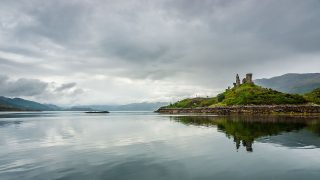
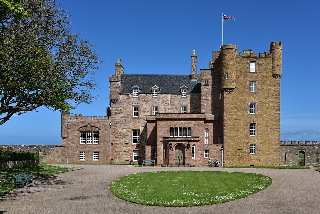
Now you’ll arrive at the fairytale castle of the Scottish Highlands, Dunrobin Castle. Dunrobin Castle is the most northerly of Scotland's great houses and the largest in the Northern Highlands with 189 rooms. Dunrobin Castle is also one of Britain's oldest continuously inhabited houses dating back to the early 1300s, home to the Earls and later, the Dukes of Sutherland.
Carn Liath is a broch, a sophisticated type of Iron Age settlement accompanied by the rare survival of an associated village and earthworks. You can see it from the road, but there is a small car park on the opposite side of the road where you can park and walk over to the broch if you wish.
Brora: Just outside of the village of Brora is the Clynelish Distillery which includes both a modern distillery and a 19th century one with tours and tastings are available to the public.
Helmsdale: Today the town is famous for its salmon fishing, but originally it prospered as a result of the herring boom of the 19th century. The Timespan Heritage Centre uses an award-winning combination of life-size displays and audio-visual exhibits to tell the story of the area from earlier times. The other thing to see in Helmsdale is a bronze statue on a hill called The Emigrants which is a touching memorial to those who left Scotland during the Highland Clearances.
Caithness
The Ord of Caithness lies 2 miles on from Helmsdale on the boundary between the old counties of Sutherland and Caithness. It is a low granite mass rising to 198m, steeply above the sea at Ord Point, a headland on the coast.
Ten miles along the coast lies Badbea. This was one of the villages in the area where evicted people settled during the Highland Clearances. Today, the ruins of the village are preserved as a tourist attraction and memorial to the Highland Clearances. There is a small car park here and a path to the former village. The last resident left the village in 1911 and a monument was erected by the son of former inhabitant, Alexander Robert Sutherland, who had emigrated to New Zealand in 1839.
Dunbeath: A few miles before you reach the village you will pass Dunbeath Castle – although a castle has stood here since the 15th century, the present building is of mainly 17th-century origin, with 19th-century extensions. Its gardens are available for viewing by appointment only. In the village is the Dunbeath Heritage Centre located in the old village school, it details the lives of crofters. There are a number of archaeological sites nearby like Dunbeath Broch with a nice walk which includes the broch, a carin, and standing stone. Just outside Dunbeath along the route is the Laidhay Croft Museum which includes a 250-year-old rush thatched Caithness Long House which you can explore which is cluttered full of antique furnishings as well as a byre or barn with tools.
Latheron: Near Latheron, is the Clan Gunn Museum & Heritage Centre which is a museum dedicated to the history of the Clan Gunn which is located within the Latheron Old Parish Church. There is also a large standing stone (over 12 feet high) in a field in Latheron called the Buldoo stone or Latheron stone. Further along towards Lybster sit the ruins of Forse Castle, you can’t see it from the road but it can be seen from the coastal hiking path between Dunbeath and Lybster.
In between Dunbeath and Wick are a number of archaeological sites. The most popular are the Achavanich Standing Stones – 36 smaller stones part of a stone circle, Grey Cairns of Camster – Neolithic burial chambers, Yarrows Archaeological Trail, Cairn o’ Get, and Hill o’ Many Stanes.
Lybster: This small village hosts the Waterlines Heritage Museum located at the Lybster fishing harbour. The museum focuses on local history and its former importance as a fishing station.
10 miles further on are the Whaligoe Steps – a man-made stairway of 330 steps that were hand-cut to lead down to a scenic harbour between two sea cliffs. It was was once a landing place for fishing boats.
Thrumster: Near the village is the Yarrows Archeological Trail which is a hiking path along which are the remains of a Mesolithic site, Neolithic chambered tombs, Bronze Age hut circles, and a broch. It starts near the southwest part of the Loch of Yarrows and there is a parking area here and signage. The full walk takes about 1.5 to 2 hours to complete.
Wick: This is actually two towns Wick and Pulteneytown, which was developed on the south side of the river by the British Fisheries Society during the 19th century – you can find out more at the Wick Heritage Centre. There is the Old Pulteney Distillery which is open for public tours and tastings, a golf course, three harbours, and a Carnegie library. You can also hike up to Old Wick Castle, which is a 12th century ruin along a cliff.
Three miles to the north east of wick lies the Noss Head Lighthouse. This is an active 19th-century lighthouse that overlooks Sinclairs Bay. There is a small parking area before you arrive at the private drive to the lighthouse, which is still actively used.
A kilometre from the lighthouse is the ruins of the 15th-century Castle Girnigoe that site perched on top of a rugged cliff. Since the 1300's a castle has dominated this headland and grew alongside the power of Clan Sinclair and the Earl's of Caithness until it was abandoned in the late 1600's.
Keiss: This is a small fishing village at the northern end of Sinclair’s Bay. You can parking on the High Street or at Keiss Harbour and walk north along the coastla path past Keiss Broch and Whitegate broch and another Clan Sinclair ruined castle, known as Old Keiss Castle.
Furth up the coast lies the tiny hamlet of Auckengill with the Caithness Broch Centre housed in the Old School House. It is near to Nybster Broch, an Iron Age broch and there also the Mervyn Tower – a monument to Sir Francis Barry, an English businessman who excavated the Nybster broch in 1900.
John o’ Groats: The village is famous for being at one end of the 876-mile “End to End” route that connects it to Land’s End, Cornwall. The northernmost point in mainland Britain is actually the nearby Dunnet Head, however John o' Groats does have its well photographed signpost! Just northeast of John o' Groats you can make a 20 km drive to Duncansby Head lighthouse. Apart from the lighthouse there is a great sea cliff walk taking in the Duncansby Stacks.
Mey: This tine village lies East of John O’Groats. It is where the late Queen mother had here Scottish home at the Castle of Mey . It was another former Sinclair castle. It is open to the public seasonally for visits (fee for entry) and you can tour the castle, the gardens, and visit the family farm animal centre.
Dunnet: Dunnet Head is the most northerly point in mainland Britain. At Dunnet Head there is a stone marker here next to the parking area and a well-marked short path to a viewpoint. Near Dunnet is Mary Ann’s Cottage, a well-preserved croft home dating back to 1850. It is open in the summer between 2-4.30pm.
Castletown: The village is located in the southeast of Dunnet Bay and has the Flagstone Heritage Trail and the Castlehill Heritage Centre which between them celebrate the memory of the flagstone industry in this part of Caithness.
Thurso Town: This is the largest town along the northern section of the North Coast 500. Thurso, is a popular place for surfing and national championships have been held in Thurso. It has the ruins of St. Peter’s Kirk – which is one of the oldest churches in Scotland, and the ruins of the 19th-century castle Thurso Castle. The North Coast Visitor Centre is located in the former Town Hall building, covers the history of the local area. It is usually stepping stone to the Orknays.
Crosskirk: This is a small hamlet, mostly of agricultural and coastal land, around 6 miles west of Thurso in Caithness. The area has historical connections with a lost broch, and St Mary's Church and burial ground, the Chapel dates back to the 12th century and is the oldest church building in Caithness.
Northern Sutherland
Bettyhill: The Strathnaver Museum, is located in the former Parish Church of Columba in Bettyhill. It covers local history and has a whole room dedicated to Clan Mackay. Its most famous item is the 9th century Farr Stone, an engraved Pictish gravestone. The Strathnaver Trail, which links and interprets 29 archaeological sites starts here. The sites include a wide range of sites, including the remains of Neolithic horned chamber cairns, Pictish carved stones, war memorials, Bronze Age cairns and hut circles, Iron Age brochs and pre-Clearance townships. Also nearby is the crescent shaped, sandy Farr Beach.
Torrisdale: There is a superb walk at Torrisdale which takes in Torrisdale Bay and Broch. The walk takes in a spectacular beach, dunes, riverside and moorland, as well as visiting an iron-age broch with stunning views.
Tongue: This is a small village on the eastern shore of the Kyle of Tongue – a shallow sea loch. The village has a WC, small shop, post office, fuel station, and a few dining options. There is a pleasant 1 hour round trip hike to the ruins of Castle Varrich, a 14th century castle built by Clan Mackay. There is a viewing platform inside allowing visitors a higher viewpoint over the Kyle of Tongue. Varrich Castle has views of mountains Ben Loyal and Ben Hope.
Durness: The little village of Durness sits above Sango Sands bay, and offers amenities such as a WC shops, fuel and a pub. Smoo cave is located a mile to the east of Durness. It is an impressively large sea cave accessible via steps from the car park. Parts of the cave were occupied in prehistoric times, perhaps as early as 10,000 years ago. You can explore the outer chamber on foot for free. To the west of Durness lies Balnakeil Beach & Faraid Head.
Close to Durness is the ferry point to visit Cape Wrath. Cape Wrath is a special wildlife area, has a lighthouse designed by Robert Stevenson, and is an active military training area for the Ministry of Défense. A visit to Cape Wrath would take 3 to 4 hours (see https://www.visitcapewrath.com).

Kinlochbervie: This is a small West Highland crofting community with a little harbour and unfortunately a large fish-processing plant. To the north west lies Sandwood Bay , reputedly the most beautiful beach in Britain. To get there drive along the single-track road north west of the village, passing Oldshoremore and its beach (a haven for wildflowers) to the Blairmore Car Park (WC). From here is a 4 mile walk to a to Sandwood Bay, 1.5 miles wide pink sand flanked by cliffs.
Tarbet: The small fishing hamlet of Tarbet (WC) has a seafood restaurant called the Shorehouse (not open in Winter) and a small speedboat ferry to Handa Island (total trip will take about 4 hours – https://handa-ferry.com/).
Scourie is a small crofting village with a small harbour and a great place to stock up or stay the night: a WC, campsite, fuel and food. The palm trees in the grounds of Scourie House next to the harbour are claimed to be the most northerly specimens in the world not grown in artificial conditions. See the ‘Paths around Scourie’ leaflet to find some great walking routes.
Kylesku Hamlet: Here you have the striking Kylesku bridge, built in 1984 and a nice roadside scenic viewpoint. You can also take seasonal sightseeing boat trips on Loch Glencoul which will pass by Eas a’ Chual Aluinn, Britain’s highest waterfall. A little further on at Unapool you’ll find the Rock Stop Café and Exhibition Centre about the North West Highland GeoPark.
Route Detour: You now have the choice travel along the steep and narrow B869 along the coast or continue along the A894 direct to Lochinver.
Assynt
Drumbeg: This small village has a Hotel and small shop.
Clashnessie: This is a small crofting village scattered around the sandy beach of Clashnessie Bay. There is a car park for the beach and you can also take a short hike to nearby Clashnessie Waterfall, (walk away from the beach until you see a small sign).
Before you reach the next village of Stoer you can make a 15 minute detour to see the Stoer Head Lighthouse. It is another Stevenson lighthouse with great views. You can walk from the lighthouse to the Point of Stoer and the Old Man of Stoer seastack (3 hours round trip).
Clachtoll: Clachtoll is a coastal fishing and crofting village situated on the Bay of Clachtoll. It has a campsite and iron-age broch of An Dùn and a pretty beach with its imposing Split Rock.
Achmelvich: This is not really a village, more a small campsite and caravan park, a youth hostel, and some of the most enticingly beautiful beach scenery in northern Scotland. Hermit's castle is a small concrete folly built in the 1950's in a Brutalist style.
Lochinver: The village of Lochinver is the largest village in Assynt and is an important fishing port. The village has all the basic amenities and a range of lodging options. It is a popular base for lovers of the outdoors outdoor pursuits. South of Lochinver there is a 4-mile round trip to the Falls of Kirkaig or adventure up Assynt’s iconic hill, Suilven.
Along Loch Assynt you’ll pass the ruins of Ardvreck Castle and Calda House sitting next to the loch.
Inchnadamph: This is a small hamlet that contains contains a few houses, a lodge, a hotel and a historic old church, graveyard and mausoleum. Just south of Inchnadamph is the hiking path to the Bones Caves (1.5 hours round trip).
The low cliff of Knockan Crag (WC) exposes rocks that set the scientific world ablaze in the 19th century, with the discovery that a slice of old rock sits on top of much younger ones. Rock Room is an unattended open air visitor centre with information panels describing the history and geology of the local landscape and the importance of the discovery of the Moine Thrust. There are also three trails that you can take of varying lengths that go up the hill and there are signs, sculptures, viewing points, and small exhibits along the way.
About 10 miles before Ullapool you can turn off the main road to head to Achnahaird Bay, considered one of Scotland’s best beaches. You will alos pass the car park to walk up Stac Pollaidh.
Ardmair: Past the tiny village of Ardmair there is the Rubha Cadail Lighthouse. You can park and take a 10 minute walk to the Rhue lighthouse with great views of the Summer Isles and Loch Broom.
Wester Ross
Ullapool Town: Ullapool’s has a large harbour with a ferry terminal to Lewis and Harris. It has a small museum housed in a former Parliamentary church designed by Scottish engineer Thomas Telford, and a golf course. To the south lies Leckmelm Shrubbery and Arboretum planted between around 1870 to around 1930 and restored in 1984.
Just after you turn onto the A832 is the Corrieshalloch Gorge National Nature Reserve which provides pleasant woodland trails, a Victorian suspension bridge over the tree-lined gorge, and the Falls of Measach. There are no facilities here.
The Ardessie Falls are situated below An Teallach and Sail Mor. Climbing up the paths beside this waterfall gives you excellent views out over Little Loch Broom.
Laide: This is a small village on the southern shore of Gruinard Bay and offers views of Gruinard Island and the Summer Isles. There are the remains of an unroofed medievel chapel chapel and a nearby wood that you can visit.
The Inverewe Garden is a large garden that includes a lovely collection of trees, flowers, and other plants along the loch. Because of the Gulf Stream, even some tropical plants thrive here and it is a lovely garden to explore with lots of meandering trails. There is also a seasonal cafe, shop, Inverewe House.
Poolewe: This is a pretty little village on the shores of Loch Ewe. There are some hiking opportunities, such as this circular hike around Poolewe that circles Loch Kernsay.
Gairloch Village: The village is on the shore of Loch Gairloch. Gairloch Museum is the local heritage museum which just got a new building and has been recently redeveloped, definitely worth a stop for those interested in the local history. There is also a marked archaeological trail here called the Sands Archaeological Trail which leads to some local archaeological ruins and you can learn more about it at the museum. The small fishing village also has hasa small harbour, whale cruises, and several small shops and cafes. There is small beach next to the golf club and if you drive 4 miles north of Gairloch along the B8021 there is the Big Sand Beach. Beyond Big Sand beach is Rua Reidh Lighthouse.
The loch Maree and the area became famous for trout fishing in the Victorian period after the area was visited by Queen Victoria in 1877.
A third of the way down the Loch, near Talladale, you come to a small carpark, which has a trail leading to the Victoria Falls, a small waterfall named after Queen Victoria.
Kinlochewe: A small village to the south of Loch Maree is a great place to explore the Beinn Eighe National Nature Reserve. It offers mountain and pinewoods trails to explore.
A little further up the A832 is the Glen Docherty viewpoint with great views of Glen Docherty and Loch Maree. Again visited by Queen Victoria on her way to Loch Maree.
Torridon Village: You will be relieved to arrive at Torridon, a small pretty village, after the 10 mile single track road from Kinlochewe. Torridon has long been a magnet for hikers and climbers with the village lying in the shadow of three mountains Beinn Eighe, Liathach and Beinn Alligin, all of which are over 3000 feet in height. If you want a break why not visit the Torridon Countryside Centre and Deer Museum.
Sheildaig: The route to the next village of Sheildaig also has some steeps sections. Shieldaig has great views over the nature reserve Sheildaig Island and also a pleasant walk around Shieldaig Peninsula.
Route Detour: At Sheildaig you can detour to Ardarroch or carry on the coast road to around the Applecross Peninsula with its lovely views of the Isle of Skye, Isle of Raasay, and Rona along the coast.
Applecross: The name Applecross applies to all the settlements around the peninsula, including Toscaig, Culduie, Camusterrach, Sand, to name a few, but there is also a village of Applecross. At Applecross you can learn about local history and heritage at the Applecross Heritage Centre & Clachan Church and even visit the local Broch.
The Bealach na Ba pass is a historic and quite famous pass through the mountains of the Applecross peninsula and was originally built in 1822. Bealach na Ba, meaning pass of the cattle, was used in earlier days to drive cattle from Applecross and surrounding settlements to other parts of the Highlands. It is one of the highest roads in Scotland and offers some scenic views along its many twists and turns.

Lochcarron Village: The village sits on the edge of a lake called Loch Carronit is the home to the Lochcarron Tartan Weavers. The world’s largest manufacturer of authentic tartans. You can learn more about tartan, the weaving process, and there is also the obligatory shop. To the south along the loch, is the ruins of the 14th century Strome Castle.
A slight detour to the south, past Strathcarron are the Attadale Gardens, which are open seasonally to the public. The gardens were started in the late 19th century by a plant collector on the Attadale Estate, importing rhododendrons from all over the world.
The next highlight is a visit to the Rogie Falls, a series of small waterfalls on the Black Water. Rogie Falls has a series of lovely walks on the Black Water which you can follow to see the waterfall that is famous for salmon viewing.
To the north east of Contin lies Strathpeffer is a leafy Victorian spa town surrounded by wooded hills.
You then drive back to your starting point of Inverness.

Moira & Andy
Hey! We're Moira & Andy. From hiking the Camino to trips around Europe in Bert our campervan — we've been traveling together since retirement in 2020!
This website uses affiliate links which earn a small commission at no additional cost to you.