Self-Guided Walking Tour of Marrakesh, Morocco (2026)
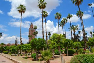
Koutoubia Mosque in Marrakesch
CC BY-SA 4.0 / Max221B
This website uses affiliate links which earn a small commission at no additional cost to you.
Marrakesh, the vibrant heart of Morocco, is a city where ancient traditions and bustling modern life coexist in a kaleidoscope of colors, scents, and sounds. From the maze-like alleys of the Medina to the grand palaces and serene gardens, every corner of Marrakesh tells a story. A walking tour allows visitors to immerse themselves fully in the city's energy, exploring its souks, historic sites, and lively public squares at a pace that reveals its rich cultural layers.
The city is renowned for its iconic landmarks, including the bustling Jemaa el-Fnaa square, where snake charmers, storytellers, and food stalls create a sensory spectacle, and the Koutoubia Mosque, whose striking minaret is visible across the city. Wandering the narrow streets, you encounter traditional riads, artisan workshops, and centuries-old markets, each offering a glimpse into the city's history and daily life. The contrasts between the bustling Medina and the tranquil gardens or palaces highlight the diverse experiences that Marrakesh offers on foot.
A walking tour also provides an intimate connection with Marrakesh's art, architecture, and culture. From the intricate tilework of the Bahia Palace to the vibrant displays of spices, textiles, and pottery in the souks, visitors can experience the city's aesthetic richness firsthand. By exploring on foot, you gain a deeper appreciation of the city's layered history, the rhythms of everyday life, and the warmth of its people, making a walking tour an essential way to experience Marrakesh.
By Air:Marrakesh Menara Airport (RAK) is the main international gateway, located just 15 minutes by taxi from the city centre. For the best deals and a seamless booking experience, check out these flights to Marrakesh on Booking.com.
By Train:Marrakesh is the final stop on Morocco's rail network from Casablanca and Rabat. The train station is about a 10-minute drive from the Medina. Train schedules and bookings can be found on Omio.
By Car:Marrakesh is well connected to major cities like Casablanca and Agadir via highways. If driving, be aware that parking inside the Medina is limited-consider using outer car parks and walking in.
Where to Stay in Marrakesh
To make the most of visiting Marrakesh and this walking tour, it is best to stay overnight in the centre, particularly in or near the Medina, where many of the city's iconic landmarks, souks, and squares are within easy walking distance. In the heart of the Medina, Riad Kniza offers an authentic Moroccan experience with luxury and traditional décor. Another popular choice is La Maison Arabe, known for its refined riad-style accommodations and excellent location close to Jemaa el-Fnaa. For a more boutique experience, Riad Be Marrakech provides a quiet retreat within the bustling Medina.
In the slightly more modern area of Gueliz, Le Palais Rhoul & Spa combines contemporary comfort with traditional Moroccan charm, while Kenzi Club Agdal Medina offers spacious rooms and amenities ideal for families or those wanting resort-style facilities near the city centre. Four Seasons Resort Marrakech is a luxurious option, blending tranquil gardens with easy access to the main attractions of both the Medina and the newer districts.
A Brief History of Marrakesh
Marrakesh, founded in 1070 by the Almoravid dynasty, quickly became one of Morocco's most important cities, serving as a political, cultural, and economic hub. The city's iconic Jemaa el-Fnaa square has been the beating heart of Marrakesh for centuries, hosting markets, storytellers, and performers, and remains a symbol of the city's vibrant public life. Over time, Marrakesh expanded with impressive architectural projects, including the Koutoubia Mosque, constructed in the 12th century under Almohad rule, whose soaring minaret is a defining landmark visible from across the city. Surrounding the mosque, the Koutoubia Gardens (also known as Lalla Hassna Park) provide a green oasis amidst the urban bustle.
During the Saadian period in the 16th century, Marrakesh saw a flourish of art and architecture. The Saadian Tombs reflect the dynasty's craftsmanship and ornate design, while the El Badi Palace, commissioned by Sultan Ahmed al-Mansur, was built to showcase the city's wealth and power. The later Bahia Palace, constructed in the late 19th century by Grand Vizier Si Moussa and his son, demonstrates intricate Moroccan artistry with expansive courtyards, lush gardens, and elaborate tilework. Religious life also shaped the city, with landmarks like the Kasbah Mosque serving as spiritual centers for centuries.
Marrakesh’s city walls, including the famous Bab Agnaou gate, stand as enduring reminders of its strategic importance and historical fortifications. The Musee Dar Si Said, housed in a former palace, preserves Moroccan art and crafts, offering insights into the city’s cultural richness. From its bustling squares to grand palaces and historic mosques, Marrakesh’s layered history-from Almoravid founding through Saadian and later Moroccan dynasties-can be explored on foot, revealing a city where past and present intertwine seamlessly.
Guided or Self-Guided Tour of Marrakesh?
Marrakesh’s medina is an atmospheric maze, and while it’s thrilling to explore independently, a local guide adds context and direction. The Marrakech: Bahia Palace, Saadian Tombs, Souk and Medina Tour is a top-rated experience that covers major highlights in a few hours. Led by an expert guide, you’ll delve into hidden corners of the souks, uncover the significance of ornate monuments, and gain a deeper understanding of Marrakesh’s layered history.
Your Walking Tour of Marrakesh
This blog highlights Marrakesh’s essential stops, but give yourself time to get lost in the medina’s rhythm-sometimes the best sights are the ones you stumble upon.
1. Jemaa el-Fnaa
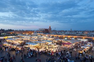
Djemaa el FnaMarrakesh
CC BY-SA 3.0 / Boris Macek
Jemaa el-Fnaa is a great place to start our tour. Look for the Minaret de la Koutoubia in the west. You will use this to orient yourself if you get lost!
The Jemaa el-Fnaa is Marrakech’s main square and the most important part of the medina. Jemaa el-Fna is the city’s top attraction and can be visited at all hours of the day. At this fascinating spot, you’ll find snake charmers, the magical souk, monkeys and henna artists. The best view of Jemaa el Fna is from one of the roof terraces framing the edge of the square. Look for Le Grand Balcon du Café Glace – it is perfectly positioned to witness the full scale of the activity on the square below.
Location: Jemaa el-Fnaa, Rue des Banques, Marrakesh, Morocco | Hours: Effectively 24/7, with the liveliest period from late afternoon into late evening. | Price: Free - Jemaa el-Fnaa is a public square open to everyone.
Leave the square by the eastern road (away from the Minaret de la Koutoubia), turn right onto Rue Riad Zitoun el Jdid by the restaurant Marrakchi. About halfway down this street (by the Herboristerie La Musée – avoid this place), you nee to turn left – you may need to ask for directions or find the sign posts for the Musee Dar Si Said.
The Musée Dar Si Saïd, also known as the Museum of Moroccan Art, is housed in a stunning palace in Marrakech. The palace was built in the mid 19th century for Si Saïd ibn Moussa, the Minister of War, and boasts a beautiful courtyard with flowers, cypress trees, a gazebo, and a fountain. The exhibition rooms surrounding the courtyard are adorned with intricately carved doors, intricate stucco work, and mosaics, as well as a domed reception room and harem quarters.
The museum’s collection is highly regarded and includes jewellery from various regions in Morocco, carpets, oil lamps, pottery, and leather work. A standout piece in the collection is a 10th-century Spanish marble basin, which was brought to Marrakech by Sultan Ali ben Youssef in 1120 and initially placed in a mosque despite its depiction of an eagle and griffons, which goes against Islamic law. The basin was later moved to the Ben Youssef Madrasa and eventually donated to the museum after the college’s restoration.
Traveling to a country with a different currency? Avoid ATM transaction fees and pay in local currency with a Wise Card. Having used it for over 5 years, we've saved loads on fees!
3. Bahia Palace
Bahia Palace large court
CC BY-SA 4.0 / Val Traveler
Head south from the Musée Dar Si Saïd, turn right onto Rue de la Bahia. You should pass the Tiskiwin Museum on your right. You shoudl turn left onto Rue Riad Zitoun el Jdid, at the end of which is theentrance to the Bahia Palace.
The Bahia Palace, also known as the “Palace of the Brilliant/Beautiful,” is a stunning late 19th century palace that spans 8 hectares, including a garden. Located close to the royal El Badi Palace and about 900 meters southeast of Jemaa el-Fnaa, the Bahia Palace is an oasis of calm in the midst of the bustling medina souk and offers a respite from the noise of traffic. The complex features 150 rooms, patios, courtyards, fountains, and gardens, and is adorned with intricate tile work, mosaics, coloured glass, carvings, and elaborate ceilings.
Originally built for Si Moussa, the Grand Vizier of Sultan Hassan I, the Bahia Palace was the largest and most luxurious palace in Morocco at the time. During the French Protectorate, it was the residence of General Hubert Lyautey, who added electricity, fireplaces, and heating. Although the rooms are not furnished with period furniture, the tiled walls and ceilings more than make up for it. Visitors can explore the palace in about 30 minutes, but it is also enjoyable to spend more time taking in all of the details of the palace.
From the Badia Palace head west and you will soon find yourself in the Place des Ferblantiers,a palm-lined square in the Mellah with artisans selling handcrafted tin lamps & housewares. People will probably approach you to tell you that the Badi palace is closed for lunch, but that is not the case. Don’t listen to them, the palace is open non-stop all day!Leave the square to the south through the archway. Turn right onto Rue de Berrima.
The El Badi Palace, also known as the “Incomparable Palace,” was once a grand and stately palace but now stands in ruins. Commissioned by Sultan Ahmed el-Massour of the Saadian Dynasty in 1572 to celebrate his victory over the Portuguese in the Battle of the Three Kings, the El Badi Palace was intended to be the most impressive building in Marrakech. However, the sultan died before the palace was completed in 1603.
The El Badi Palace was a massive complex with 360 rooms surrounding an interior courtyard that measured 135 meters by 110 meters and featured fountains and a large pond. The palace was funded using reparation debt imposed on Portugal after the battle and was decorated with mosaics from Italy, gold fittings from the gold mines of Sudan, and onyx, ivory, cedar wood, and semi-precious stones.
After the Saadian Dynasty fell to the Alaouites in 1683, Sultan Moulay Ismail stripped the El Badi Palace of its valuable decorations to use in his new palace in another town, and the El Badi Palace slowly fell into ruin. Visitors can explore the ruins of the palace and climb an internal staircase on the northeast side to a small terrace with a view of the complex. The palace also houses a small museum containing a restored 12th-century carved minbar (Imam’s pulpit) from the nearby Koutoubia Mosque.
Continue along the Rue de Berrima to the Saadian Tombs.
The Saadian Tombs, located in the Kasbah of the royal district in the medina of Marrakech, offer a glimpse into the beauty of ancient Morocco. The tombs were commissioned by Sultan Ahmed Al-Mansur of the Saadian dynasty in 1554 for himself and his family, and are the only surviving remnants of the dynasty’s reign, which lasted from 1554 to 1659. When the dynasty fell to the Alaouites, the new sultan attempted to destroy all evidence of the Saadians’ rule, but spared the tombs, which were partially sealed off (although important individuals were still buried there until 1792).
The Saadian Tombs are incredibly well-preserved due to their partial sealing and protection from external elements. The “Hall of the Twelve Columns,” where Al-Mansur and 60 members of the Saadian family are entombed, is adorned with imported Italian marble, intricate tile work, gilded honeycomb muqarnas, and elaborate, detailed and colorful ceilings. The “Hall of the Three Niches” houses important princes, while approximately 170 chancellors and their wives are buried in the garden.
The tombs were discovered in 1917 through aerial photography and were lovingly restored by the French organization, the Beaux-Arts Service. The tombs offer a peaceful resting place for those interred within.
The Kasbah Mosque is one of the oldest and largest mosques in Marrakech, having been built in 1190. It is the second-best-known mosque in the city after the Koutoubia Mosque and features typical Almohad architecture. The mosque opens onto a square surrounded by interesting buildings and has a distinct minaret, which served as a prototype for many later minarets in the Maghreb and al-Andalus and is decorated differently from the minaret of the Koutoubia Mosque. The exterior of the mosque is imposing, with high walls topped by merlons above a row of corbels and large pointed horseshoe arches, some of which are now walled-in, while others frame the gates of the mosque or house shops.
The Kasbah Mosque has undergone multiple restorations and is now in excellent condition. It is an active place of worship, with the call to prayer drawing in hundreds of worshipers daily (although it has the capacity to accommodate many thousands more). Non-Muslims are not permitted to enter the mosque, but it is still enjoyable to sit outside and take in the atmosphere. The area around the mosque is quieter and more open than other parts of the medina, and there are several nice cafes where visitors can sit and appreciate the surrounding architecture.
Location: Koutoubia, جامع الكتبية،، Avenue Mohammed V،، Marrakesh, Morocco | Hours: The mosque is active for daily prayers; non-Muslims may visit the surrounding square and streets at any time during daylight hours. | Price: Viewing the exterior is free; nearby Saadian Tombs and El Badi Palace charge separate entrance fees of a few euros each.
Explore Marrakesh at your own pace with our self-guided walking tour! Follow our curated route to discover must-see sights and local secrets that makes Marrakesh one of the best places to visit in Morocco.
7. Bab Agnaou & the Walls of Marrakech
Marrakech City Gate
CC BY-SA 2.0 / János Korom Dr
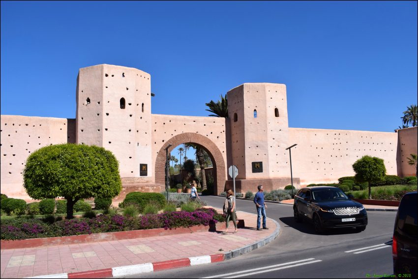
Bab Agnaou, located in the southwest corner of Marrakech, is one of the 19 huge gates that once guarded entry into the city as part of its protective walls. It is the most noteworthy of the surviving gates, with rich decoration reflecting the 12th-century fortification design and embellishments. At one point, the gate served as an entrance to the El Badi Palace, home to the royal family, and was more of a decorative feature than a defensive one.
The entryway of the Bab Agnaou gate is a large horseshoe arch with concentric circles of symmetrical carvings – four semi-circular carved arcs, one above the other, with geometric floral patterns and a frieze along the top inscribed with verses from the Koran in Kufic lettering. The gate is constructed of Gueliz sandstone, which gives it its blue/ochre color. The two broken areas at each end of the top suggest that two slender towers once stood in this location, which may be the source of the gate’s name, “Agnaou,” which means “sheep without horns” in ancient Berber.
Today, the Bab Agnaou gate is a popular photo opportunity in the old city of Marrakech, a UNESCO World Heritage Site.
Location: Bab Agnaou, Marrakesh, Morocco | Hours: Accessible at all times, though exploring in daylight is recommended for safety and photography. | Price: Free - walking along and around the walls and gates is part of the public streetscape.
From Bab Agnaou head north to see Lalla Hasna Park and the Koutoubia Mosque.
Lalla Hasna Park is a pretty garden just west of the Koutoubia. Laid out with pools, roses, palms and orange trees. it’s the prefect place to stroll or sit while enjoying views of the mosque.
Location: Parc Lalla Hasna, Marrakesh, Morocco | Hours: Generally open at all daylight hours, though the most comfortable and lively times are from early morning until late evening. | Price: Free - this is a public park open to everyone.
The Koutoubia Mosque and minaret, located 200 meters west of Jemaa el-Fnaa on Avenue Mohammed V, is the largest mosque in Marrakech and serves as a useful landmark for orienting oneself within the medina’s labyrinth. The mosque’s name, “Koutoubia,” is derived from the Arabic “al-Koutoubiyyin,” which means “bookseller,” as the area was once home to many sellers of books and manuscripts. The mosque is closed to non-Muslims, but everyone can enjoy the adjacent park, which features trees (palms, orange, olives), flower beds, fountains, and benches, at all times for free.
A smaller predecessor mosque was built on this site in 1147 by the Almohad dynasty after they defeated the Almoravides and took control of Marrakech. However, the qiblah wall of the mosque, which should have faced Mecca, was incorrectly oriented, so instead of correcting its position, the Almohades built a new, larger mosque nearby and the old one fell into disuse. The current mosque is constructed of reddish-brown sandstone and is decorated with curved window arches and pointed “merlons” or crenellations.
The Koutoubia’s minaret is a square structure that stands 69 meters high and 13 meters wide, with six rooms stacked on top of one another and crowned with a ceramic strip, small tower, and four gilded copper balls decreasing in size. The north-western side of the minaret contains ruins and cisterns from an Almoravid palace that stood on the site before the Almohades took over.
Location: Koutoubia Mosque, جامع الكتبية،، Avenue Mohammed V،، Marrakesh, Morocco | Hours: Non-Muslims can’t go inside the Koutoubia Mosque or minaret but are most likely to get a glimpse inside on a Friday when the doors are open for prayers. | Price: Free to visit the exterior, gardens, and surrounding area.
This website uses affiliate links which earn a small commission at no additional cost to you.
Walking Tour Summary
Distance: 3.5 km Sites: 9
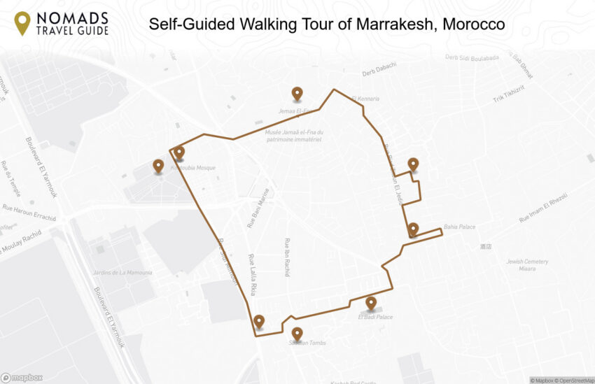
Walking Tour Map
Preview map of the Self-Guided Walking Tour of Marrakesh, Morocco route in Marrakesh, showing 9 stops. Use the interactive map to zoom and tap markers.
This website uses affiliate links which earn a small commission at no additional cost to you.
Brescia, a captivating city in Italy's Lombardy region, offers a rich tapestry of Roman ruins, medieval architecture, and vibrant piazzas. Less visited than nearby Milan or Verona, Brescia rewards curious travellers with a surprisingly deep cultural experience, from UNESCO-listed Roman remains to Renaissance squares full of local life. Walking through the city reveals layers of history that unfold across every street and monument.
This historic richness is matched by a modern vitality-you'll find markets, cafés, and museums nestled alongside ancient temples and cobbled alleys. Whether you're interested in archaeology, architecture, or authentic Italian city life, Brescia is an under-the-radar gem best explored on foot.
By Air: While Brescia doesn't have its own major airport, the city is conveniently served by nearby airports that make flying in easy. The closest is MilanBergamo Airport (Orio al Serio), about 40 kilometers away, which handles many low-cost and international flights. Verona Villafranca Airport is another nearby option, roughly 70 kilometers from Brescia, offering a wider range of connections. From either airport, you can reach Brescia by shuttle bus, train, or rental car in about 40 to 60 minutes, making it a quick and convenient journey for travelers flying in. For the best deals and a seamless booking experience, check out these flights to Brescia on Booking.com.
By Train:Brescia is a well-connected stop on the Milan-Venice rail line, with frequent trains to and from both cities, as well as regional routes to Lake Garda, Bergamo, and Trento. The train station is about a 15-minute walk from the city centre, or a short local bus or taxi ride. Use Omnio to easily compare schedules, book train tickets, and find the best prices all in one place for a hassle-free journey across Italy.
By Car:Brescia is located just off the A4 motorway, making it easy to access from Milan (90 km west) or Verona (70 km east). The most convenient exits are Brescia Ovest and Brescia Centro. There are multiple paid parking options close to the historic centre, including Parcheggio Piazza Vittoria and Parcheggio Stazione FS. Driving too close to the historic centre is a little dangerous as the area between Piazza Loggia-Piazza Paolo VI squares and Corso Zanardelli is a pedestrian and restricted access (ZTL) area, monitored through video surveillance. Accidentally drive there and you can get a healthy fine. There is plenty of parking towards the train station. You can also go for parking in Freccia Rossa Mall. Buy something in the mall and parking is free! If you are looking to rent a car in Italy I recommend having a look at Discover Cars, first, as they compare prices and review multiple car rental agencies for you.
Where to Stay in Brescia
To make the most of visiting Brescia and this walking tour, it's best to consider staying overnight in or near the city center. This area allows you to be within easy walking distance of Brescia's historic sites, charming piazzas, and vibrant local life, making your exploration smooth and enjoyable. The heart of the city, around Piazza della Loggia and Via dei Musei, is a popular choice for visitors looking to immerse themselves in Brescia's rich history and culture. Here you can find comfortable and stylish options such as Hotel Vittoria, which offers elegant rooms right in the city center, or Hotel Igea, known for its welcoming atmosphere and modern amenities. For those seeking a boutique experience, Relais San Clemente provides a cozy, historic setting close to key attractions. Additionally, AC Hotel Brescia combines contemporary design with convenient access to the city’s main sites and transport links. Staying in these central areas means you can easily return to your hotel to rest between stops on the walking tour, maximizing your time enjoying everything Brescia has to offer.
A Brief History of Brescia
Brescia, located in the Lombardy region of northern Italy, has a rich history that stretches back over 3,200 years. Its origins date to pre-Roman times, and it became an important Roman municipium known as Brixia. The city's Roman heritage remains visible in the Piazza del Foro and the Roman Theater, where remnants of ancient columns, arches, and structures testify to its early prominence as a regional center of commerce and governance. The civic heart of the medieval city developed around Palazzo Broletto and Piazza Paolo VI, which have long been gathering places for local government and public life.
During the Renaissance and Baroque periods, Brescia saw a flowering of religious and civic architecture. The twin cathedrals, Duomo Vecchio (Old Cathedral) and Duomo Nuovo (New Cathedral), dominate the skyline with their impressive facades and interior artworks, while churches such as Santa Maria della Carità showcase the city's spiritual and artistic heritage. Piazza Loggia, with the Palazzo della Loggia, reflects the civic pride of Renaissance Brescia, serving as a symbol of governance and culture that has endured for centuries.
Brescia's cultural and historical significance is further preserved in institutions like the Civici Musei d'Arte e Storia Santa Giulia, which houses archaeological finds, art, and artifacts from the region, and Brescia Castle, a fortress that illustrates the city's strategic importance throughout the medieval and early modern periods. Walking through the streets of Brescia today, visitors can trace the city's evolution from Roman municipium to medieval stronghold, and then to a Renaissance and Baroque cultural center, with layers of history visible in its piazzas, churches, and museums.
Guided or Self-Guided Tour of Brescia?
While Brescia’s compact centre makes it easy to explore on your own, a guided tour brings its fascinating history to life. This Private Guided Walking Tour leads visitors through key landmarks such as the Capitolium, Duomo Vecchio, and Piazza della Loggia. With a local guide, you’ll gain insight into the layered past that shaped this often-overlooked city.
Your Walking Tour of Brescia
This guide touches on Brescia’s major attractions, but as with any Italian city, much of its charm lies in wandering off-route-so take your time, enjoy a spritz, and discover its quieter corners.
1. Palazzo Broletto and Piazza Paolo VI
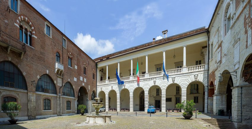
Cortile del Broletto e fontana a Brescia
CC BY-SA 2.5 / Wolfgang Moroder.
Piazza Paolo VI is part of the historical centre of Brescia, previously it was also known as Piazza del Duomo due to the presence of the two cathedrals of the city, and it was named after Pope Paul VI.
Palazzo Broletto, which today includes the Civic Tower (Torre del Pegol) and Loggia delle Grida, located on the northeastern side of the square, dating back to the 13th century. Broletto is the symbol of the democratic-political power since the middle age although can seems rather insignificant besides the huge, stunning “new cathedral” and the early-medieval “old cathedral”. Today it houses the Prefecture, the Provincial Administration and some municipal offices.
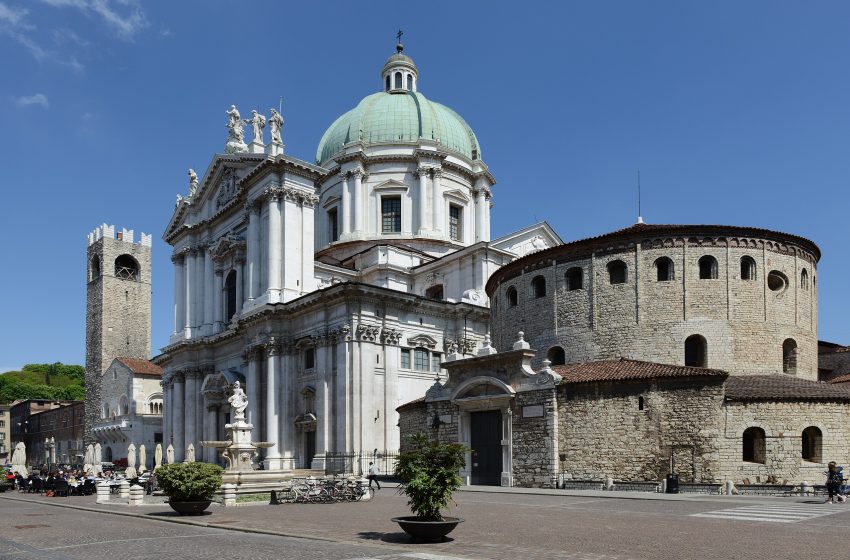
On the eastern part of the square, we can also find the New Cathedral of Brescia (Duomo Nuovo), built between 1604 and 1825 (it took a while to build due to due to financial difficulties), in various architectural styles ranging from late Baroque to Rococo. It was designed by architect Giovanbattista Lantana and built on the remains of the old San Pietro de Dom church. It has a splendid Baroque façade in Botticino marble and it’s dome is the third tallest in Italy.
The Duomo Nuovo has eight chapels, although these are really no more than niches. The interior, a one-nave Greek cross design, is very monumental and contains several noteworthy works of art. Look out for the 15th century wooden crucifix on the first altar on the right; Isaac’s Sacrifice painted by Moretto in the lunette of the same altar; and St. Apollonio’s sarcophagus in the third altar (he was Bishop of Brescia in the 3rd century), made in 1510 and decorated with high-reliefs attributed to Maffeo Olivieri. In the Trinity Chapel, the altarpiece by Giuseppe Nuvolone is noteworthy; it’s a grandiose ex voto to celebrate the end of the plague in 1630.
The next structure is the Old Cathedral (Duomo Vecchio), known also as La Rotonda, an example of Romanesque architecture from the 11th century. Duomo Vecchio was built starting from 1100 by a very old Corporation of specialised masons. Also called “Rotunda” for its circular shape, it is the official co-cathedral of Brescia together with Duomo Nuovo.
Here is a complete selection of hotel options in Brescia. Feel free to review each one and choose the stay that best suits your needs.
3. Santa Maria della Carità, Brescia
Santa Maria della Carita
CC BY-SA 4.0 / Bragowonder
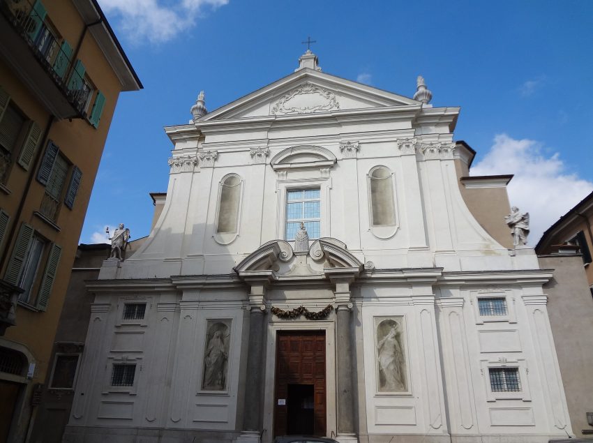
Santa Maria della Carità, is also known as the Church of the Good Shepherd , and is one of the most exciting expressions of the Baroque in the city. This temple of art and spirituality was built in the 16th century to be rebuilt in 1640 and finished in 1825 with the raising of the large cross on the dome. The sculptural and pictorial ornaments on the facade date back to the first half of the 18th century.
Inside, the sumptuous high altar stands out , one of the most beautiful in Brescia, with the image of the Virgin of the Terragli placed in the second half of the seventeenth century and behind which a chapel similar to the Holy House of Nazareth was built , the original of which is kept in Loreto, and the splendid octagonal floor with polychrome marble.
The result is a perfect integration with the stuccoes and frescoes of the walls and with the architectural perspectives of the dome.
Traveling to a country with a different currency? Avoid ATM transaction fees and pay in local currency with a Wise Card. Having used it for over 5 years, we've saved loads on fees!
4. Piazza del Foro and Roman Theater
Teatro Romano frammenti colonne Piazza del Foro Brescia
CC BY-SA 2.5 / Wolfgang Moroder
Piazza del Foro, adjacent to Via Musei.
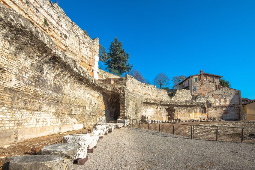
The Piazza del Foro is one of the oldest squares in Brescia, as it was the centre of the political life of Roman Brixia. The square is framed by ancient palaces and residences. From Roman times date the Tempio Capitolino and the Basilica, which served as a courthouse at that time. The Roman columns that are still standing, used to be in front of shop spaces. The Palazzo Martinengo is graced by the Fountain of Neptune and the statue of Cesare IV Martinengo.
Opposite the Capitolium Theatre are the small Baroque church of San Zeno al Foro and the remains of the porches that ran around the square perimeter. The ground level at the time was much lower than today‘s and these remains give a great perspective of where the city was in those old days. By the square, surrounded by historic aristocratic residences, stands Palazzo Martinengo, built in the 17th century and used today to host temporary exhibitions. It also contains a wooden scale model of the whole area giving you a true window over the past of the city.
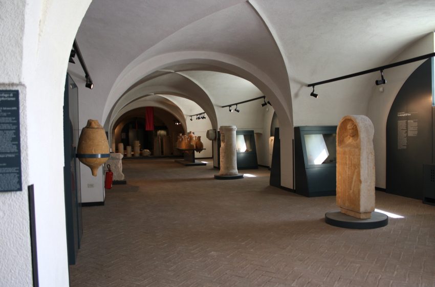
Santa Giulia Museum is one of the main tourist and cultural attractions of Brescia. Also known as “City Museum”, its important historic displays and fascinating location make it a unique site. It’s an exceptional example of former monastery turned into a museum. It hosts incredible collections from Prehistory to the present day and temporary exhibitions of international relevance.
Together with the Capitolium archaeological area and the San Salvatore monastery complex, Santa Giulia Museum is a UNESCO World Heritage Site.
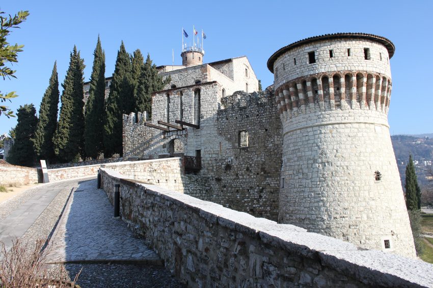
Brescia’s Castle stands perched on Cidneo hill and many Brescians consider it the symbol of the city. The castle still bearing the traces of the various dominations of the past. The Mastio, the fortified keep on the top of the hill, with its mighty Torre dei Prigionieri (Tower of the Prisoners), the drawbridge and the Mirabella Tower, the last trace of the church of Santo Stefano in Arce overlooking the town, bear witness to the communal period and the Visconti domination. The imposing bastions, with their monumental gate, are testaments to the power of the Republic of Venice – La Serenissima – that ruled the city for about four centuries.
Piazza Loggia, one of the three main squares in Brescia. Palazzo della Loggia is a beautiful palace built in Renaissance style in Brescia, located in the square of the same name, today the seat of the city’s Municipal Council. On the east side of the square are elegant porches with the Clock Tower surmounted by two automatons who strike the hours.
Palazzo Loggia was built between 1492 and 1570, like the square that hosts it, it presents itself in its grandeur and at the same time with a simple and clean style. The façade, made of Botticino marble, has columns and pilasters with rich sculptural decorations. In the lower part you cannot fail to notice the large portico , accessible from three sides through three large arches and today often used for events and musical moments. Also under the portico there are two fountains also made in Botticino marble.
Get to Know the Six Sestieri of Venice 2026: Neighborhood Guide
Six Areas of Venice
This website uses affiliate links which earn a small commission at no additional cost to you.
Venice is the largest city in the Veneto region of Italy. The city is constructed masterfully upon the murky lagoon, whose waters surround it, protected from the Adriatic by a strip of land, a barrier island called the Lido.
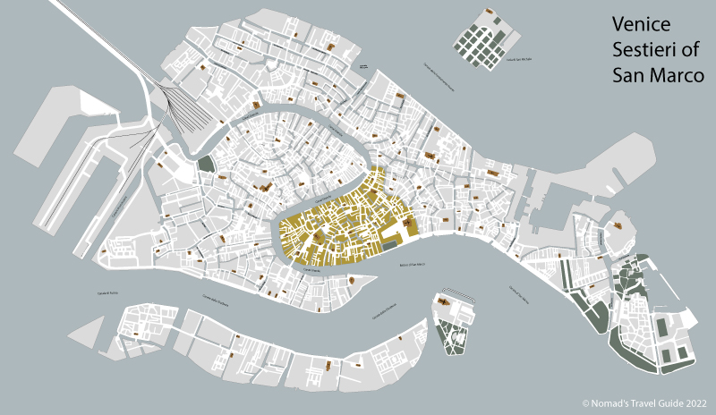
The different areas of Venice, are known as “sestieri”, with each having its own specific charms and tourist attractions Here's a quick overview of the six districts of Venice.
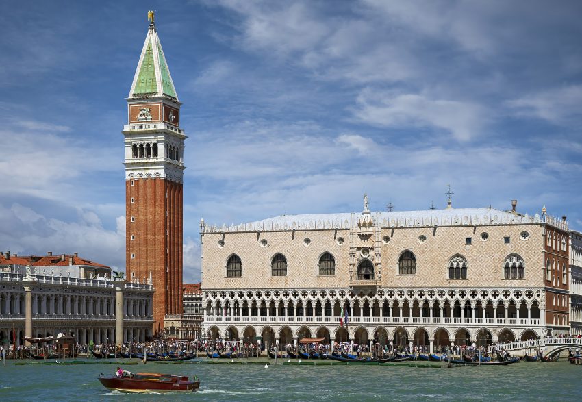
Named after the city’s patron Saint and the true heart of the city ever since its foundation, San Marco holds many of the cities most famous landmarks. Piazza San Marco, its stunning Basilica and its Campanile, as well as the Palazao Ducale (Doge’s Palace).
So if you're on a Venice day trip with limited time, you'll probably want to spend most of your time in this quarter. San Marco also includes the island of San Giorgio Maggiore.
Cannaregio is Venice’s largest district, and is home to the city’s Jewish Neighbourhood and the Jewish Museum of Venice, which explains the sestiere’s fascinating history.
Situated in the centre of Venice, San Polo is the smallest of the six districts, as well as one of the oldest. This more laidback part of the city has plenty to recommend it, with the Rialto Market, established in 1097 and Campo San Polo (the city's second largest square, after San Marco) both located here. The iconic Rialto Bridge connects this district with San Marco, so it’s easy to get to when you want to explore a slightly quieter part of the city.
Dorsoduro is located in the southeast part of Venice and includes Giudecca island. Known for being the city's university district and one of the 'cool' areas of Venice, Dorsoduro is a great place to go if you're a bookworm, as it has some fantastic bookshops.
The whole of the area brims with eateries and nightlife. Among its many gems, the district is home to the Ca’ Foscari University, the Punta della Dogana and the Peggy Guggenheim Collection.
Santa Croce is close to the Santa Lucia train station and the only sestiere of Venice where cars and buses are allowed to drive. While not as pretty as the other sestieri it still holds the Museo di Storia Naturale di Venezia within the old Fondaco dei Turchi, and the vibrant square of San Giacomo dell’Orio and its historic church. This district is also the location of the city’s main bus terminal at Piazzale Roma, so you’ll be passing through if you arrive in Venice on the bus.
Castello is one of the least visited parts of Venice, which makes it a great place to head if you're keen to escape the crowds. It's the true art hotspot of the city Castello is the domain of the Giardini della Biennale, with their thirty pavilions, each belonging to a different country that uses them to display their works of art every two years.
This website uses affiliate links which earn a small commission at no additional cost to you.
More from this area
Venice on a Budget 2026: How to Explore the City for Less
venice on a budget
This website uses affiliate links which earn a small commission at no additional cost to you.
With its iconic canals, picturesque gondolas, and winding streets, it's no surprise that Venice is considered one of the most romantic cities in the world. But while the city is popular with honeymooners, it's also a huge destination for cruisers and backpackers too.
Venice is beautiful, fun, and full of narrow streets and alleys to get lost in. It's a magical place unlike any other. There are museums, palaces, historic town squares to explore, and endless gelato to eat.
Unfortunately, the city is also expensive and over tourism has become a real problem. No matter what time of the year, you’re going to encounter crowds. In fact, if you come in the summer, it’s going to be unbearable (and if you come when a cruise ship is docked, it’s even more unbearable!)
How to get to Venice
By Train: This is a very convenient way of getting to Venice. You will need to arrive at Venezia Santa Lucia (ignoring Venezia Mestre & Venezia Porto Marghera railway stations). A return train ticket from Padova will cost €10, from Mira-Mirano on the ourskirts of mainland Venice only €6.
Parking: You can drive to Venice although you will have to pay for parking. Tronchetto car park costs €22 for 24 hours.
Getting Around Venice
Water taxis: Water taxis (speedboats) are a wonderful way to get around, but a bit expensive. A trip from the train station to San Marco will cost at least €70!
Vaporettos (water buses): are busses on the water, they leave from the stop called Ferrovia right outside Santa Lucia station. You're looking at €7,50 for a single ride and €21 for a day pass. See https://actv.avmspa.it/en/content/vaporetto. Waterbus line 1 links Piazzale Roma (where the buses and road vehicles arrive), Ferrovia (= Santa Lucia station), Rialto, San Marco & Venice Lido, and runs early until late, usually every 12 minutes or so.
Walk: The main sites are all 20-30 minutes away from the station. You will get lost but should still be able to find the main sites.
San Marco Museum Pass
A single ticket to visit the 4 magnificent buildings and museums of St. Mark’s Square: the Doge’s Palace, the Correr Museum, the Archaeological Museum and the Museum Rooms of the Marciana Library: € 30 (€ 25 if you buy 1 month in advance from https://muve.vivaticket.it/).
Museum Pass
This gives you the same as above but also access to: Museum of Palazzo Mocenigo; Carlo Goldoni’s House; Ca’ Pesaro, International Gallery of Modern Art + Oriental Art Museum; Glass Museum - Murano; Lace Museum - Burano; Natural History Museum; Fortuny Museum. (€ 40. Buy from https://muve.vivaticket.it/)
Chorus Pass
If you want to visit more than 4 churches in Venice it is cost effective to purchase the Chorus Pass (gives free access to 18 churches in Venice): € 12.
1. Rialto Bridge
Ponte di Rialto Canal Grande
CC BY-SA 4.0 / Veronika.szappanos
There are two ways to get the the Rialto Bridge to the left of the grand Canal, through Santa Croce and San Polo or to the right through the Carnnaregio sestieri and the Jewish quarter.
Santa Croce and San Polo: Start by walking out of the station and turning left to cross the beautiful Ponte degli Scalzi across the Grand Canal, completed in 1934. It’s the elegant stone bridge you’ll see to your left when you walk out of the station. Then follow the many street signs to Rialto, keep the Grand Canal on your left about 5-6 blocks ways from you.
Carnnaregio sestieri and the Jewish quarter: You quickly reach the Chiesa dei Santi Geremia e Lucia, and cross over into the Jewish Quarter, if you want to find out more about this area detour and visit the Jewish Museum of Venice. After walking for about 3 minutes you need to turn of the street you are in to head to the right down Calle del Pistor. Generally follow this street, passing over 4 bridges. When you get to Chiesa Cattolica Parrocchiale dei Santi Apostoli turn off to cross over another bridge, turn immediately left under the arcade. From here you can follow signs for Per S. Marco.
Rialto Bridge was the city’s first bridge over the Grand Canal connecting the highest points on the Venice islands settlement. The first bridge was built in 1180 and the current solid marble one was built in 1588-92.The bridge is an elegant arch with steps and shops, a mass of water traffic passing underneath, and huge numbers of tourists and locals heading across it.
Today, Rialto Bridge is one of the most photographed images in Venice and a major stop on the tourist trail. Rialto Bridge is located about the mid-point of the Grand Canal connecting the main arrival point for visitors at the Railway Station with St Mark’s Square being the main visitor destination. In the immediate area of Rialto Bridge, on the southern bank is the main food market Mercato di Rialto.
For great views of the bridge head towards the nearby Fondaco dei Tedeschi and its rooftop terrace. Book in advance at https://www.dfs.com/t-fondaco/rooftop-terrace-booking/booking/terrace_venice_en.html.
From the Rialto Bridge turn right as you come off the bridge from San Polo. Look for the signpost directing you to St Mark’s Square.
St. Mark’s Basilica, known in Italian as Basilica di San Marco and popularly as San Marco Basilica, is a medieval church in Venice. It is devoted to honouring the remains of St. Mark, the patron Saint of Venice. The Basilica is the pride of Venice and its history dates back to the 9th century. The marvellous architecture blends Byzantine, Romanesque, Islamic, and Gothic influences. St. Mark’s Basilica is open every day from 9:30 AM to 5:15 PM, if you have not booked in advance you need to purchase tickets to the side of the Basilica at Piazzetta dei Leoncini. Tickets cost €3 for the Basilica (although free for prayers, Mass and Service), €10 for the tower and €7 for the Museum & Loggia dei Cavalli (the balcony overlooking the St. Mark’s Square).
The Basilca and St Mark’s Campanile are a very cost effective way of seeing the splendour of Venice.
The Doge’s Palace is one of the symbols of Venice. The palace has been used for everything from the residence of the Doge to the prison of the Venetian republic. Originally a fortified castle founded between the tenth and eleventh centuries. The palace was partially destroyed by a fire and was rebuilt between 1172 and 1178, as was the Piazza San Marco. During this period, the Palazzo was used as a fortress and prison. The structure combines layers of different architectural styles, including Byzantine, Gothic and Renaissance. This impressive building houses paintings by renowned Italian artists such as Titian, Tintoretto and Bellini. The building has been the Doges’ residence and public offices since the old castle was built in 810. Over nearly 1,000 years, 120 doges ruled over Venice from the Doge’s Palace.
The main areas yo will see are:
The armory, a collection of over 2,000 artifacts including a few unusual objects.
The courtrooms where laws were made, and cases were heard.
The doge’s chambers are private rooms containing a shrine, priceless paintings, and two globes showing how the world was understood at the time.
The secret rooms, which include cells, interrogation rooms, and a torture chamber.
The chamber of the Great Council, where important state meetings were hosted.
Traveling to a country with a different currency? Avoid ATM transaction fees and pay in local currency with a Wise Card. Having used it for over 5 years, we've saved loads on fees!
You will head to the island to the south Dorsoduro, which holds the Venice university and will probably a more economical place to eat than St Marks Square! Head west from St Marks Square cross 5 bridges until you get to a large square – Rielo de le Erbe. Head south from here to cross over Ponte dell’Accademia to reach Dorsoduro.
.
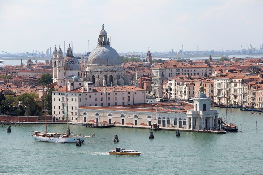
You have a number of options here. Punta della Dogana – Pinault Collection is an art museum, in a triangular former customs house, exhibiting international contemporary artworks. Basilica di Santa Maria della Salute and Gallerie dell’Accademia.
This website uses affiliate links which earn a small commission at no additional cost to you.
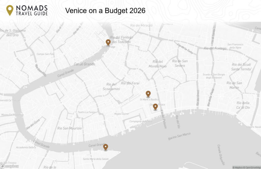
Walking Tour Map
Preview map of the Venice on a Budget: How to Explore the City for Less route in Venice, showing 4 stops. Use the interactive map to zoom and tap markers.
Guide to Visiting Piazza San Marco 2026: Landmarks, Tips & Map
Piazza San Marco
This website uses affiliate links which earn a small commission at no additional cost to you.
The famous Piazza San Marco, known in English as St Mark's Square, is the main public square in Italy's floating city, Venice. With a glowing reputation as one of the finest squares in the world and arguably one of Europe's primary tourist attractions, it certainly has a lot to offer to visitors.
The popular Piazza San Marco, known amongst locals as ‘La Piazza’, is found at the southern base of the Grand Canal. Napoleon called the Piazza San Marco “the finest drawing room in Europe.” Inside it’s surrounded by stunning Baroque and Victorian era buildings and monuments.
When to visit Piazza San Marco?
Due to its popularity, we recommend that you head to PIazza San Marco first thing in the morning to avoid the big crowds. Start your day in this magical square with a sit-down coffee at one of the cafés before moving on to see the rest of Venice. Be careful when visiting during periods of heavy rain, as the square is prone to flooding.
How long is needed to visit Piazza San Marco?
You should reserve at least half an hour to visit Piazza San Marco. A little longer if you want to stop for a coffee or visit the Basilica San Marco or Museo Correr.
What should I wear to visit Piazza San Marco?
Dress comfortably on your trip to Piazza San Marco. You’re likely to be doing a lot of walking and exploring all day, so wear relaxed shoes and clothing. If you’re having lunch or dinner at a particularly exclusive venue, go for something that’s chic yet relaxed.
How to get to the Piazza San Marco?
If on foot just follow the yellow “San Marco” signs on the corners of buildings. The walk from the train station or the Piazzale Roma will take 30 minutes to an hour or more, as long as you don’t stop off on route.
When was Piazza San Marco built?
The piazza was laid out in the 11th Century, when its area was divided in half by a canal near the café tables in the picture. A century later, the canal was filled in, creating the basic shape that exists today. A major building project got underway in the 16th Century, and new stone paving replaced the old bricks in the early 1700s.
What you will find in the Piazza San Marco?
This beautiful Piazza is surrounded by shops, caffè’s and palazzi on three sides including the historic and expensive Caffè Florian. According to local legend Napoleon called the Piazza San Marco “the drawing room of Europe.” A full breakdown is below.
1. Basilica di San Marco
Basilica San Marco
CC BY-SA 2.0 / Gary Ullah
We will start our guide looking at the Basilica di San Marco or St Mark’s Basilica.
Looking at the Basilica you will notice the four bronze horses on the loggia above the porch. originally part of a monument depicting a quadriga (a four-horse carriage used for chariot racing). The horses were placed here after the sack and looting of Constantinople in 1204 The four horses have historically been symbols of the great power of Venice.
The Basilica di San Marco was built in 832 AD to house the remains of the city’s patron, Saint Mark. The holy man’s body was brought from Alexandria, Egypt by two Venetian merchants who smuggled it concealed in the barrels of pork meat, which they rightly regarded the Muslim guards would never touch. According to legend, the night the body arrived in the lagoon, St Mark was greeted by an angel, saying, “Peace be with you Mark, my Evangelist. Here shall your body rest”. Over the centuries, this legend has inspired many works of art.
200 years later, a sumptuous temple was built upon the foundations of an earlier church, and was consecrated when St Mark’s body was interred beneath the high altar. The new basilica was modelled after the celebrated Church of the Apostles in Constantinople. To enhance its opulence, the structure was subsequently clothed in marble and mosaics depicting scenes from the Old and New Testaments, as well as the lives of Christ, Virgin Mary and St Mark himself.
Many of the mosaics were later retouched or remade, as artistic tastes changed and the damaged mosaics had to be replaced, so the ones currently in place represent 800 years of artistic styles. Some of them derive from traditional Byzantine representations and are masterworks of Medieval art; others are based on preparatory drawings made by prominent Renaissance artists from Venice and Florence, such as Paolo Veronese, Tintoretto, Titian, Paolo Uccello, and Andrea del Castagno.
Andrea del Castagno was active at San Marco in the mid-15th century, introducing a sense of perspective largely achieved with architectural settings. Attributed to him is the mosaic in the Mascoli Chapel, depicting the Dormition of the Virgin. Tintoretto, in his turn, created the mosaic in the central nave depicting the Presentation of Jesus at the Temple (16th century), while Titian designed and executed, between 1524 and 1530, the mosaic decoration of the Sacristy vault depicting Old-Testament prophets.
On the north side of the Basilica you will find the Piazzetta dei Leoncini.
The Piazzetta dei Leoncini (Piazzetta meaning small piazza) is named after the two red marble lions sitting in the Piazzetta that were presented to Venice by Doge Alvise Mocenigoin in 1722.
Here is a complete selection of hotel options in Venice. Feel free to review each one and choose the stay that best suits your needs.
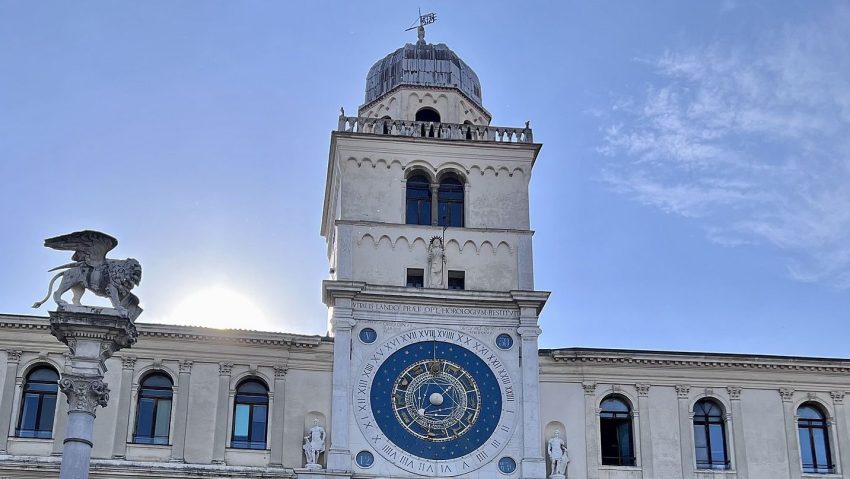
3. Torre dell'orologio
Torre dellOrologio
CC BY-SA 3.0 / Mister No
Turning to our left (anti clockwise) to look at the Torre dell’Orologio.
In a square filled with iconic Venetian buildings, this remarkable Renaissance clock tower holds its own. Its base has always been a favorite meeting point for Venetians as it marks the entrance to the ancient Merceria, one of the busiest streets in Venice, now home to both high-end boutiques and trinket shops.
The tower’s clock itself was made the official timekeeper of Venice as far back as 1858. It notably not only tells the time but is also aid to the astrologer, matching zodiac signs with the position of the sun.
Above the clock’s face, against a field of golden stars, you can see a winged lion of St Mark, symbol of Venice found practically everywhere around the city. Beneath the lion is a statue of the Virgin Mary and Baby Jesus who also seem to be watching over Piazza San Marco.
The two men striking the bell at the extreme top of the clock tower are some of the most peculiar Venetian characters. Originally, these were two shepherds who, but after being reproduced in bronze, grew significantly darker with time, and thus, got the nickname of “Moors”.
If you decide to climb the tower, you may want to book a tour. There are two English tours run every day, each limited to 12 people only. On this tour you will see a secret door and then stop at every level all the way to the top to observe the clock mechanism and other curious things within the tower, along with San Marco square itself down below.
Traveling to a country with a different currency? Avoid ATM transaction fees and pay in local currency with a Wise Card. Having used it for over 5 years, we've saved loads on fees!
4. Procuratie Vecchie & Caffè Lavena
Cafe Lavena Piazza San Marco Venezia
CC BY-SA 3.0 / qwesy qwesy
To the left and running along the north side of the Piazza is a long arcade. These buildings built in the early 16th century are called the Procuratie Vecchie (old) and were the homes and offices of high state officials during the Republic of Venice. Today, at ground level the arcade houses shops and restaurants including the famous Café Lavena.
Established in 1750 café Lavena has its origins in the popular Venice of the 17th century. As the other cafés of St Mark’s Square, Lavena equally had its part in intellectual life in the city. The person who gave lustre to Caffé Lavena, patronizing it from his first coming to Venice and becoming an habitual customer, was the composer Richard Wagner. Almost every day from five to six in the afternoon, Wagner used to visit Caffé Lavena and stay for half an hour, conversing very often with the owner Carlo Lavena.
Other famous persons that has frequented Caffé Lavena include the Venetian violinist Raphael Frontalli, famous composers and writers along with the current plethora of famous and not so famous movie stars that visits during the annual Venice Film Festival. Café Lavena is a great place to sip coffee with your loved one in a sunny afternoon and watch the world go by.
Turn towards the east. The buildings facing the Basilica at the end of Piazza San Marco and to the left of Caffè Lavena is the Procuratie Nuove (New Procuracies) or Ala Napolenica (Napoleon Wing) so called because it was rebuilt by Napoleon in 1810. This wing is occupied primarily by shops as well as the grand staircase leading to the Correr Museum.
Museo Correr is a fine arts museum found in Piazza San Marco. From the Neoclassical Rooms in the Napoleon Wing to the spacious rooms of the Procuratie Nuove. Museo Correr offers a wonderful insights into Venetian history, culture and art. Here you’ll discover the daily life of Venetians through the ages and see fascinating examples of their art up until the early 16th century. Even if you’re not a big admirer of classical art, it’s worth a visit for the amazing views over the Piazza!
Location: Museo Correr, Piazza San Marco, Venice, Metropolitan City of Venice, Italy | Hours: (Summer) 01 April – 31 October; Daily: 10:00–18:00.
(Winter) 01 November – 31 March; Daily: 10:00–17:00.
| Price: €30 (St Mark’s Square Museums ticket, includes Doge’s Palace + Museo Correr + National Archaeological Museum + Monumental Rooms of the Biblioteca Marciana); reduced €15. | Website
Turning left down the southside of the Piazza are the Procuratie Nuove (new) that were built starting around 1582. (Remember, the Procuratie Vecchie were built in the early 1500’s). The ground floor holds more shops as well as the very famous Caffè Florian opened in 1720. When Austria ruled Venice in the 19th century, after the fall of Napoleon, the Venetians sipped their coffee at the Florian while the hated Austrians were at Quadri’s across the Piazza. The upper floors of this section of buildings house the Correr Museum. At the far end is Sansovino’s Liberia dating from the mid-16th century. The building also houses the Museo Archeologico.
Towards the end of the Procuratie Nuove is the Campanile di San Marco
The city’s tallest bell tower was originally constructed in the 12th century, as a combined lighthouse and belfry, and was continuously modified up until the 16th century, when the golden angel was installed on its summit. Back in the day, each of the five bells here had a distinct function: the largest bell tolled the start and the end of a working day; another bell rang midday; two other bells either proclaimed a session of the Senate or called members of the Grand Council to the meetings; while the smallest of the bells gave notice of a forthcoming execution.
It was at the top of this belfry that Galileo Galilei famously demonstrated his telescope to the Venetian Doge on 21 August 1609 – the event commemorated by a plaque at the tower’s observation deck. Still, the most dramatic event associated with the Campanile took place on 14 July 1902, when the tower fell down shortly after giving a sound of warning to the leisurely coffee drinkers at piazza below, sending them run for their lives!
The Venetians put the Campanile back “where it was and how it was”, and the tower is now safe to climb to the very top. Unlike other belfries where you have to brave a narrow, steep spiral set of stairs to reach the top, the Venetian one has an elevator so you can easily get a pigeon’s eye view just for a fee.
Standing 99 meters high, the Campanile is the tallest structure in Venice; an ideal vantage point for observing the cupolas of the San Marco basilica and further afield, including the surrounding lagoon.
Behind the Campanile di San Marco lies the Marciana Library.
The Marciana Library or Library of Saint Mark is a public library in Venice, Italy. It is one of the earliest surviving public libraries and repositories for manuscripts in Italy and holds one of the world’s most significant collections of classical texts. It is named after St Mark, the patron saint of the city.
Location: Biblioteca Marciana, Piazza San Marco, Venice, Metropolitan City of Venice, Italy | Hours: (Summer) 01 April – 31 October: Daily: 10:00–18:00 (last entry 17:00).
(Winter) 01 November – 31 March: Daily: 10:00–17:00 (last entry 16:00). | Price: St Mark’s Square Museums ticket (includes Museo Correr, National Archaeological Museum, and the Monumental Rooms of the Biblioteca Marciana): €30 (full) / €15 (reduced). | Website
The Piazzetta di San Marco is an open space connecting the south side of the Piazza to the lagoon, The Piazzetta lies between the Palazzo Ducale (Doge’s Palace) and the Biblioteca Marciana (St. Mark’s library).
At the open end of the Pizzetta di San Marco are two large granite columns. Sitting on top of the first column is Saint Theodore, the patron saint of the city prior to St. Mark. Saint Theodore is holding a spear with a dragon / crocodile that he is said to have slain. This is a copy of the original which is housed in the Palazzo Ducale (Doge’s Palace). Sitting on the second column is a winged lion of Venice, the symbol of Saint Mark. The original columns are thought to have been erected in 1268. Much activity has taken place between these two columns including gambling and public executions.
The Palazzo Ducale or Doge’s Palace in Venice is one of the main landmarks of the city. The building is an unmistakable testament to Venice’s historic wealth and power. Its facade features a gorgeous pink Verona marble – is a real Gothic masterpiece. For almost 1000 years it was the building from which 120 Doges (or chief magistrates) wielded their awesome power and decided Venice’s fate. This seat of government housed a Senate, court facilities, the secret police, and also prisons. It was also the residence of the Doge of Venice, who – once elected – would remain in his position for life.
The Palace is key to understanding the city’s history. Built on the foundations of a 9th-century fortress, this palace is unquestionably the finest secular European building of its time which, in the course of centuries, had served many purposes, including Doge residence, seat of the Venetian government, court of law, civil office, and even a prison.
First built in the 14th century, much of the original palace was destroyed by fire in the 16th century reducing to ashes most of the art treasures held inside. Some of the greatest Venetian masters of the time, such as Tintoretto, Veronese, Titian, Bellini, and Tiepolo, contributed to restoring the palace to its former glory, recreating gilded stucco, sculptures, frescoes, and canvases.
The interior of the palace – spectacular furnishings and paintings, marvelously adorned ceilings – reveals lavishness on the scale that is hard to match. The most outstanding is the Grand Council chamber, featuring Tintoretto’s “Paradise”, reportedly the world’s largest oil painting. Running up to it, in terms of grandeur, is the Sala dello Scrutinio or the “Voting Hall” embellished with paintings depicting Venice’s glorious past.
By the end of the 13th century, Venice was one of Europe’s richest cities, mostly due to trading spices, silks, and wool between Europe and the Middle East. Its wealthy citizens became patrons of the arts, commissioning fabulous sculptures and paintings to decorate their palaces.
The best vies of the Bridge of Sighs is from the Ponte della Paglia, between the Doge’s Palace and the Prisons’ Palace.
Another grand Venetian landmark, the Bridge of Sighs runs between the Palazzo Ducale and the prisons. The view from the Bridge of Sighs was the last view of Venice that convicts saw before their imprisonment. The bridge’s English name was bequeathed by Lord Byron in the 19th century as a translation from the Italian “Ponte dei sospiri”,from the suggestion that prisoners would sigh at their final view of beautiful Venice through the window before being taken down to their cells.
A local legend says lovers will be granted eternal love if they kiss on a gondola at sunset under the Bridge of Sighs as the bells of the Campanile are ringing.
Location: Ponte dei Sospiri, Piazza San Marco, Venice, Metropolitan City of Venice, Italy | Hours: 24 Hours fromoutside.
(Summer) 1 April – 31 October: Daily: 09:00–19:00.
(Winter) 1 November – 31 March: Daily: 09:00–18:00. | Price: Free to view from outside; to walk across it inside, it’s included with a Doge’s Palace ticket (standard €30 / reduced €15 until 31 December 2025; standard €35 / reduced €15 from 1 January 2026, with cheaper online advance-purchase options). | Website |
This website uses affiliate links which earn a small commission at no additional cost to you.
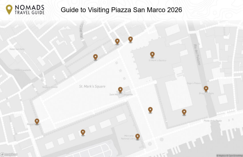
Walking Tour Map
Preview map of the Guide to Visiting Piazza San Marco: Landmarks, Tips & Map route in Venice, showing 11 stops. Use the interactive map to zoom and tap markers.
This website uses affiliate links which earn a small commission at no additional cost to you.
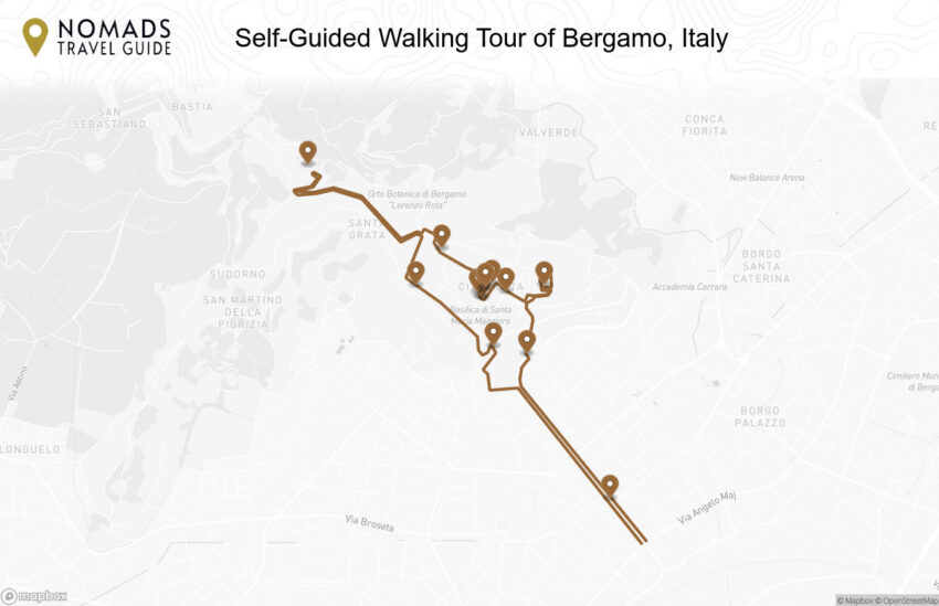
Nestled in the Lombardy region of northern Italy, the enchanting city of Bergamo has long been a hidden gem in the realm of tourism, quietly awaiting its turn in the spotlight until it was bestowed with UNESCO World Heritage Status.
Resting gracefully on the hillside, fortified by majestic walls, the city extends a warm welcome through its four gates to the world beyond. Città Alta, the Upper Town, beckons visitors with its charming artisan workshops, concealed courtyards, graceful arcades, and the allure of long, meandering shadows.
This quintessential Italian city is a treasure trove of delights, a place where every corner promises to tantalize your senses and spirit. With a rich tapestry of experiences awaiting exploration, Bergamo is a destination where the flavours, culture, and history of Italy come together to create an unforgettable journey for the heart and soul.
By Plane: Bergamo is served by Orio al Serio International Airport (BGY), also known as Milan Bergamo Airport, which handles flights from across Europe and beyond. From the airport, the city center can be reached easily by shuttle bus, taxi, or car hire in around 10-15 minutes. For the best deals and a seamless booking experience, check out these flights to Bergamo on Booking.com.
By Train:Bergamo railway station is directly connected to Milan, Lecco and Brescia (with connections for Lake Garda, Verona, and Venice). The journey times for Milan-Bergamo and Brescia-Bergamo are approximately one hour; the journey from Lecco to Bergamo takes about 40 minutes. Trains depart almost every hour. Use Omnio to easily compare schedules, book train tickets, and find the best prices all in one place for a hassle-free journey across Italy.
As you come out of the train station the tourist office is on your right and the bus station is on your left. There is a 20 minute walk from here to the funicular, alternatively you can catch the bus from here. Head to the bus station ticket office where you can purchase your tourist pass at the bus station ticket office. A tourist ticket day pass ticket for about 4 Euro which will allow you to ride the bus up to the old town, as well as take 2 funiculars.
You will need to catch the T1 Line Stazione – Porta Nuova – (Roma) – (Vitt Emanuele) – Funicolare. Buses leave every 5-10 mint
By Car: Parking is generally free only within the white lines, while it is subject to payment within the blue lines. The yellow-striped car parks are reserved for residents. You can park by the train station at the Parcheggio Ex Gasometro off Via San Giovanni Bosco and head to the train station. It is not advisable to walk back here in the dark! If you are looking to rent a car in Italy I recommend having a look at Discover Cars, first, as they compare prices and review multiple car rental agencies for you.
Where to Stay in Bergamo
To make the most of visiting Bergamo and this walking tour then you should consider staying overnight in the centre, particularly near the Città Alta, where most of the historic landmarks and charming streets are within easy walking distance. In the heart of the old town, Relais San Lorenzo offers a boutique experience with historic charm and modern comforts. Another excellent option nearby is GombitHotel, which places you steps from Piazza Vecchia and the Basilica of Santa Maria Maggiore. For a more traditional hotel experience, Hotel Piazza Vecchia provides elegant rooms right in the historic centre.
In the lower city, the Città Bassa, NH Bergamo offers contemporary accommodations and easy access to transport links, shopping, and restaurants. Excelsior San Marco Hotel is another popular choice, blending comfort with convenience near the central squares. For a more intimate stay, B&B Hotel Bergamo offers modern rooms and a welcoming atmosphere, ideal for those wanting to explore both the upper and lower parts of the city.
A Brief History of Bergamo
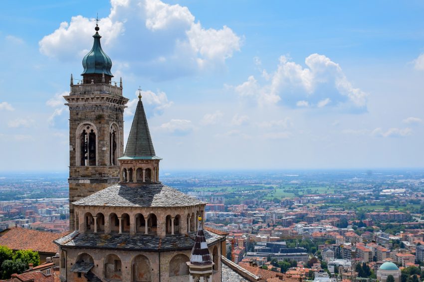
Bergamo is a city of two distinct areas: the historic upper town, Città Alta, perched on a hill, and the modern lower town, Città Bassa, which developed in the plains. The city's origins trace back to pre-Roman and Roman times, with the Torre di Gombito, a medieval tower built in the 11th century, serving as a remnant of its early fortifications. During the Middle Ages, Bergamo grew as a fortified commune, with civic and religious buildings like Piazza Vecchia, Palazzo del Podestà, and the Basilica di Santa Maria Maggiore becoming the heart of city life. The construction of the Cappella Colleoni in the 15th century, a masterpiece of Renaissance art and architecture, further highlighted Bergamo's prominence as a center of culture and devotion.
Under Venetian rule from the 15th to the 18th centuries, the city's defences were expanded, leaving the iconic Venetian Walls, Porta San Giacomo, and Porta Nuova as enduring symbols of this era. The Torre del Campanone, the battlements, and Rocca Museum atop the hill underscore the city's strategic importance, while the funicular linking the upper and lower towns demonstrates how Bergamo has blended its medieval heritage with modern transport solutions. Religious sites, including the Battistero di Bergamo, also bear witness to the city's long-standing ecclesiastical significance.
Bergamo’s cultural and scientific life has flourished alongside its architecture. Institutions such as the Museo di Scienze Naturali e Archeologico preserve the region’s natural and historical heritage, while Torre Castello San Vigilio offers panoramic views over the city and surrounding plains. Walking the historic streets and climbing the funicular reveals layers of Bergamo’s history-from its medieval origins to Venetian fortifications, Renaissance art, and modern developments-making it a city where the past is alive in every piazza and tower.
Guided or Self-Guided Tour of Bergamo?
While exploring Bergamo’s Upper Town independently is rewarding, a guided tour can provide deeper insights into its history and landmarks. The Bergamo 2.5-Hour Private Upper Town Tour offers a comprehensive exploration of the city’s highlights, including Piazza Vecchia, the Basilica of Santa Maria Maggiore, and the Colleoni Chapel. Led by knowledgeable guides, this tour enriches your understanding of Bergamo’s cultural heritage.
Your Walking Tour of Bergamo
This guide highlights Bergamo’s main attractions, but the city’s charm lies in its details. Take time to explore the lesser-known alleys, sample local delicacies, and enjoy the vibrant atmosphere of its historic squares. Whether you’re a history enthusiast or a casual traveler, Bergamo’s Upper Town offers a memorable experience.
1. Porta Nuova
Bergamo Porta Nuova
CC BY-SA 3.0 / Van Loon
From the train station walk down Viale Papa Giovanni XXIII (Pope John XXIII) to the Porta Nuova (8mins).
The first thing you will see of the Porta Nuova are a pair of colonnaded, neoclassical buildings dating from the 1830s. These were old customs houses by the city gate into the lower town of Bergamo.
Carry on straight down the via Roma to the Bergamo funicula (11 mins).
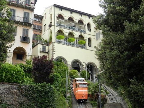
Take the most impressive means of transport into the old city. The Lower Funicular has been connecting the centre of Bergamo with the Upper Town (“Città Alta”) for more than 120 years, more precisely with Piazza Mercato delle Scarpe, where many business activities used to be carried out. The square (whose name means “shoes market square”) was used as a shoes market since 1430, while the building overlooking the square used to be the headquarter of the shoemakers’ guild and it currently hosts the funicular station.
Here is a complete selection of hotel options in Bergamo. Feel free to review each one and choose the stay that best suits your needs.
3. Rocca Museum
Bergamo Rocca
CC BY-SA 4.0 / Lauramagri712
From the Stazione superiore funicolare (Funicular upper station), you come out into the Piazza Mercato delle Scarpe. Go directly opposite and up the Via Alla Rocca, following it to the right.
The Rocca Museum is an imposing 14th-c. stronghold with a tower offering panoramic views & a museum of Bergamo’s history.
Traveling to a country with a different currency? Avoid ATM transaction fees and pay in local currency with a Wise Card. Having used it for over 5 years, we've saved loads on fees!
4. Torre di Gombito
Bergamo Torre del Gombito
CC BY-SA 4.0 / Lauramagri712
Head back to Piazza Mercato delle Scarpe. Go directly opposite and walk up Via Gombito for about 1 minutes and you will reach the tourist office and Torre di Gombito.
You used to be able to climb the 263 steps to the top of the 12th-century Gombito Tower, this is not possible for the foreseeable future.
Location: Torre del Gombito, Bergamo, Province of Bergamo, Italy | Hours: Visits must be reserved in advance at the tourist office, which is at the base of the tower, and leave at 10am, 10.45am, 11.30am, 2.30pm, 3.15pm and 4pm on Mondays.
Carry on up the Via Gombito to reach Piazza Vecchia.
Piazza Vecchia the core of Città Alta. As you enter it on your left is the Palazzo Nuovo or New Palace, which served as Bergamo’s Town Hall until 1873. Today it is the seat of the Angelo Mai Library. Its incredible collection includes ancient and precious books: incunabula, books from the 1500s, engravings, manuscripts and other inestimable artefacts making it one of the most outstanding libraries in Italy. Directly opposite this is the Palazzo della Ragione, the oldest municipal seat in Lombardy. In the northwest side of Piazza Vecchia, the fresco-dappled Palazzo del Podestà was traditionally home to Venice’s representative in Bergamo. Today, the medieval building houses a small imaginative museum with audiovisual and interactive displays that tell the story of Bergamo’s Venetian age. Admission also includes access to the Torre del Campanone, with superb views over Bergamo.
Basilica of Santa Maria Maggiore 12th 14th centuries Bergamo
CC BY-SA 2.0 / Prof. Mortel
Walk directly behind the Palazzo della Ragione to reach the Piazza del Duomo (Cathedral Square).
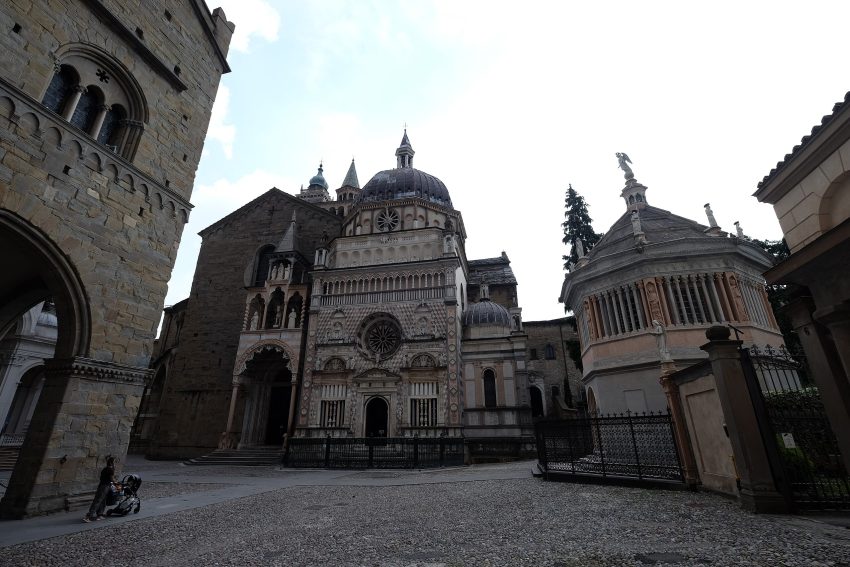
On your right you will see the octagonal Battistero di Bergamo, directly in front of you the Cappella Colleoni a 15th-century funerary chapel with its coloured marble exterior & frescoed ceiling inside. To the left and behind the Cappella Colleoni is the Basilica di Santa Maria Maggiore built in 1137 and to its right with its neo-classical facade the Cathedral of Sant’Alessandro, built in 1459.
The Cappella Colleoni, situated on the north side of the Basilica di Santa Maria Maggiore, stands as a splendid mausoleum and chapel that was constructed between 1472 and 1476. Its purpose was to honor the memory of Bartolomeo Colleoni (c. 1400–1475), a renowned Bergamese mercenary commander who led the armies of Venice in campaigns across northern Italy. Bartolomeo Colleoni now rests within this magnificent tomb.
Beneath the central dome of the chapel, Venetian rococo master Giambattista Tiepolo (1696–1770) adorned the interior with exquisite frescoes. The exterior of the chapel is adorned with a stunning display of red and white marble, showcasing an authentic Italian Renaissance masterpiece. Inside, you will encounter a captivating array of artworks, including the equestrian statue of Bartolomeo Colleoni, the marble sarcophagi, the exquisite tomb of his daughter Medea, and the intricately designed wooden desks.
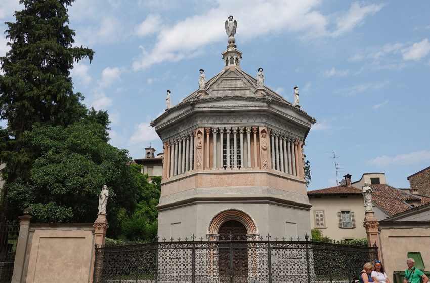
The Baptistery of the Cathedral is not just a physical structure but a profound embodiment of history, art, and faith.
It is a place steeped in history, spanning centuries. Its origins trace back to 1340 when it was built by Giovanni da Campione. However, it carries the legacy of an ancient baptistery that had stood near the Cathedral since the early days of Christianity, dating back to the 5th century. The Baptistery’s connection to the Cathedral is longstanding. Initially situated within the confines of S. Maria Maggiore, which, until the 15th century, was part of the same cathedral complex as the ancient church of S. Vincenzo. When S. Maria became independent from the Cathedral, the Baptistery was dismantled in 1660 and relocated first to the cloister of the Rectory and later, in 1898, to its present location in front of the Cathedral.
As a place of art, the Baptistery holds significant artistic treasures. It houses two remarkable sculptural cycles crafted by Giovanni da Campione: eight panels depicting key events from the life of Jesus Christ (such as the Annunciation, Nativity, Adoration of the Magi, Presentation in the Temple, Baptism, Capture and Condemnation, Crucifixion, Deposition, and Resurrection) within its walls. On the external corners, statues representing the theological Virtues (Faith, Hope, Charity) and the Cardinal Virtues (Justice, Prudence, Fortitude, Temperance) are displayed, with the virtue of Patience completing the ensemble. These original Gothic architectural elements were complemented during the relocation process.
Above all, the Baptistery is a place of faith where Christians receive the sacrament of baptism and embark on their journey of bearing witness to their commitment to Christ. It is where they are baptized and symbolically participate in the death and resurrection of Christ, supported by the grace received in baptism and nurtured through the other sacraments. The Baptistery’s octagonal shape symbolizes the fullness of God’s gift, the resurrection of Christ, and the new creation that baptism signifies.
This sacred space serves as a powerful reminder of the Christian heritage of our city and civilization, connecting us to our deep spiritual roots.
In the center of Piazza Vecchia stands the Civic Tower, fondly referred to as the Campanone. This impressive structure soars to a height of 52.76 meters and grants visitors a truly awe-inspiring panoramic view of the historic old town.
At its summit, which can be reached either by ascending 230 steps on foot or more comfortably via an elevator, resides the largest bell in Lombardy. To this day, at the stroke of 10 pm each night, the Campanone tolls one hundred times, serving as an enduring reminder of a bygone era when the city gates along the walls were sealed during the rule of the Venetians.
Adjacent to the Palazzo della Ragione, symbolizing civil authority, and the Bishopric, representing religious authority, the Palazzo del Podestà stands as a commanding presence overseeing the two main squares that served as the epicenters of medieval Bergamo: Piazza Duomo and Piazza Vecchia.
Constructed towards the conclusion of the 12th century, this magnificent palace was commissioned by the influential Suardi-Colleoni family, who generously offered it to the city. Over time, it evolved into the official residence of the Podestà, a foreign governor appointed for a six-month term to govern the municipality. In times of necessity, the Podestà had access to the prisons situated beneath the Civic Tower.
During the extensive period of Venetian rule, which commenced in 1428, the building underwent significant expansion and structural modifications, transforming it into the central hub for the administration of justice within the city.
Head back to the Piazza Vecchia and leave by the north west alley into Via Bartolomeo Colleoni. As you come out into the open in front of you is the impressive Cittadella
Head diagonally across the Piazza della Cittadella and through the arch. With the views on your left walk 50 meters and you will see some brown signs pointing to the left towards the Funicular San Vigilio and the Castello San Vigilio. You need to pass through Porta Sant’Alessandro to be back within the city walls. Catch the Funicolare S. Vigilio to the top of the hill.
Parco Del Castello Di San Vigilio is clearly visible symbol of power, the Castle of San Vigilio has for centuries been the residence Bergamo rulers for centuries. It is located 496 meters above the sea level, on top of the hill that gives it its name, overlooking the Città Alta: that’s why it used to have a strategic role in case of attacks.
Head back down the funicular and through the Porta Sant’Alessandro. bear left and walk down the Viale delle Mura. The Cittadella is the first lage building bloack on your right, the second being the Episcopal Seminary Giovanni XXIII. As the road turns sharply to the left you come to the Parco di San Giovanni or Park of St John.
Bergamo’s magnificent Venetian Walls encircle a circuit spanning over six kilometers, making it the ideal locale for a romantic stroll and the perfect vantage point to savor breathtaking sunsets. These walls have safeguarded the splendors of the Upper Town for more than four centuries and are honored as a UNESCO World Heritage site, a testament to their invaluable artistic and cultural significance.
Their construction commenced in 1561 under the jurisdiction of the Republic of Venice, initiated as a defense against potential enemy incursions. Remarkably, history, perhaps entranced by their sheer beauty, spared these fortifications from ever experiencing a siege. Consequently, they have endured virtually unchanged to the present day.
Comprising 14 bastions, 2 platforms, 100 embrasures for cannons, 2 armories, and four gates, not to mention an intricate network of underground structures featuring sallies, passages, and tunnels, the Venetian Walls offer a wealth of exploration opportunities. Don’t miss the chance to venture within the walls and explore the casemates of San Michele and San Giovanni!
However, the construction of these walls necessitated the demolition of over 250 buildings, including 8 religious establishments like the Sant’Alessandro Cathedral and the Dominican convent of Santo Stefano. Consequently, eight excommunications were issued during the course of these works.
A multitude of workers, under the guidance of both Venetian and Bergamo architects, were engaged in raising these formidable defenses due to the sheer scale of the undertaking.
The UNESCO World Heritage designation integrates the Venetian Walls into a broader, transnational site titled “Venetian fortifications between XVI and XVII Century,” intended to highlight the collective defensive systems erected by the Republic of Venice during the 16th and 17th centuries.
It’s noteworthy that some sections of these walls can trace their origins back to the Roman era, with documentation dating as far back as the 8th century. Remnants of these ancient fortifications can still be observed in locations such as via Vagine, beneath the Santa Grata cloister, and on the left side of Viale delle Mura, to the west of the funicular layout (formerly via degli Anditi). Although these ruins were in dire disrepair by the early 16th century, they were nearly entirely replaced by the new Venetian Walls, resulting in a completely fresh defensive perimeter without any vestiges of the prior fortifications.
Follow the wall of the city around until you come to the Porta San Giacomo.
Landmark white marble gate & stone viaduct overlooking the plain, preserved from a ruined city wall.
from here either take the Via S. Giacomo to the funicular, which yo catch to get to the bottom, or walk down the ramp and head left to catch the bus back to the station.
This website uses affiliate links which earn a small commission at no additional cost to you.
Padua, a historic city in Italy’s Veneto region, is renowned for its rich artistic heritage, medieval architecture, and vibrant academic atmosphere. Home to one of the world’s oldest universities and the exquisite frescoes of Giotto, Padua offers a captivating blend of cultural treasures. Exploring Padua on foot allows visitors to fully immerse themselves in its historical significance and architectural beauty.
Whether you’re admiring ancient chapels or wandering sunlit piazzas, Padua invites you to uncover centuries of creativity, faith, and scholarship.
By Plane: The nearest major airport to Padua is Venice Marco Polo Airport (VCE), located about 40 km from the city center, with regular flights from across Europe and beyond. From the airport, travelers can reach Padua by shuttle bus, train from Venice Mestre station, or car hire in roughly 40-50 minutes. For the best deals and a seamless booking experience, check out these flights to Padova on Booking.com.
By Train: Padua is easy to reach by train from many other nearby Italian cities. All the trains that move between Milan-Venice and Bologna-Venice stop in Padua. To get to the centre from the train station walk down Corso del Popolo. Use Omnio to easily compare schedules, book train tickets, and find the best prices all in one place for a hassle-free journey across Italy.
By Car:Padova is strategically located at the crossroads of major motorways in Italy. For those traveling from the west (Venice) to the east (Milan), you can access the A4 motorway (Venice-Milan) and take the Padova Est exit if you are coming from Venice or the Padova Ovest exit if you are arriving from Milan. If your journey brings you from the south (Bologna) to Padova, you'll be on the A13 motorway (Bologna-Padova). Take the Padova Sud exit, and from there, you can follow the signs guiding you to the center of Padova or continue in the direction of the A4 motorway (Milan-Venice) if you wish to travel east.
Warning: The centre of Padova is a Traffic-Restricted Area (ZTL).
Parking: The most convenient parking is Piazza Rabin, just to the south of Prato della Valle – about € 1.50 an hour. From here head north through the arch to arrive at Prato della Valle.
Where to Stay in Padua
To make the most of visiting Padua and this walking tour then you should consider staying overnight at the centre, where most of the city’s historic landmarks and charming squares are within easy walking distance. Close to Prato della Valle and the heart of the old town, Hotel Belludi 37 offers a boutique experience in a historic building with modern comforts. Another excellent choice nearby is Hotel Casa del Pellegrino, perfectly situated for exploring the Basilica of Saint Anthony and other central attractions. For a more classic hotel experience, NH Padova provides contemporary rooms and easy access to the city’s main squares.
Closer to the university area, Hotel Grand’Italia offers a historic façade combined with modern amenities, making it ideal for visitors who want to be near both the academic and cultural heart of the city. Hotel Al Santo is another good option, located steps from the Basilica and Prato della Valle, offering comfortable accommodations with a local feel. For travelers looking for convenience and modern design, Padova Center Hotel places you within easy reach of transport links while still being a short walk from the historic centre.
A Brief History of Padua
Padua is one of Italy’s oldest cities, with origins dating back over 2,500 years to pre-Roman times. Its Roman heritage is still visible in sites such as the Roman Arena and the Arena Gardens, which once hosted spectacles and civic gatherings. During the Middle Ages, Padua became a thriving cultural and religious hub. The construction of the Basilica of Sant’Antonio in the 13th century, a pilgrimage site dedicated to Saint Anthony, established the city as a spiritual centre. Nearby, Piazza del Santo and the Equestrian Statue of Gattamelata, created by Donatello in the 15th century, celebrate the city’s medieval and Renaissance achievements, while the Palazzo della Ragione, dating from 1218, reflects Padua’s role as a commercial and civic hub.
The city's intellectual life flourished with the foundation of the University of Padua in 1222, one of the world's oldest universities, housed in the historic Palazzo Bo. Padua became a centre of learning and science, exemplified by the creation of the Orto Botanico in 1545, the world's first university botanical garden. The city also embraced art and culture, as seen in the Cappella degli Scrovegni, whose Giotto frescoes remain a masterpiece of early Renaissance painting. Cultural institutions such as Musei Civici di Padova and MUSME - Museum of the History of Medicine further highlight the city's long-standing commitment to knowledge, art, and civic pride.
Padua's urban landscape combines history with public spaces that have defined city life for centuries. The grand Prato della Valle, one of Europe's largest squares, became a central gathering place in the 18th century. Iconic civic buildings such as the Palazzo Zuckermann, Chiesa degli Eremitani, and the Torre dell'Orologio in Piazza dei Signori reflect successive periods of architectural and civic development. Cafe Pedrocchi, established in 1831, became a symbol of social and intellectual life, while the Duomo di Padova and Ponte Molino showcase the city's religious and infrastructural heritage.
Guided or Self-Guided Tour of Padua?
Padua’s compact layout and scenic piazzas are easy to explore independently, but for deeper historical context, consider a guided tour. The Padua Small Group City Tour with the Scrovegni Chapel takes visitors on an insightful journey through Padua’s cultural heart. Highlights include Giotto’s frescoes in the Scrovegni Chapel, the elegant Caffè Pedrocchi, and Europe’s second-largest square, Prato della Valle.
Your Walking Tour of Padua
This blog highlights Padua’s main attractions, but your journey could easily expand-perhaps with a riverside stroll, museum visit, or glass of Prosecco in one of Padua’s timeless cafés.
1. Prato della Valle
Prato della Valle in Padua
CC BY-SA 4.0 / AnatolyPm
Prato della Valle, Italy’s largest square, stands as one of Padua’s most iconic attractions. Covering an expansive area of 90,000 square meters, it boasts an elliptical shape. The square is bordered by a canal that encircles an oval space known as the Isola Memmia, named after Andrea Memmo, the visionary behind Prato della Valle in the 18th century.
Two concentric rings of statues grace the perimeter of the canal, totaling 78 in all, each representing prominent figures intertwined with the rich history and culture of Padua. For instance, statue number 36 pays homage to Galileo Galilei, who famously declared that he “spent the happiest 18 years of his life living and teaching in Padua.” Statue number 35 commemorates the renowned humanist and poet Petrarch, who was a frequent visitor to Padua in the 14th century. Statue number 21 immortalizes the illustrious Renaissance artist Andrea Mantegna, who both studied and worked in Padua. Notably, pinpoint 12 on this list leads to the opportunity to view Mantegna’s renowned cycle of frescoes in the Church of the Eremitani in Padua.
Prato della Valle serves as a vibrant hub for many of Padua’s major events and festivals. It regularly hosts bustling markets, featuring an array of fresh produce, vintage items, and assorted treasures.
Take a moment to explore Prato della Valle, and you’ll discover a treasure trove of picturesque opportunities. The stately Lodge Amulea and the imposing structure of the Basilica of Santa Giustina present splendid subjects for your photography. Be sure to capture the beauty of these landmarks with your camera to preserve the memories of your visit.
Walk straight through the oval park, then walk anti-clockwise around it before turning onto Via Beato Luca Belludi. Quickly turn off to the right to walk down the pedestrianised Via Donatello, after 200m you arrive at the University of Padua Botanical Gardens.
The Orto Botanico di Padova is a small botanical garden in Padua, in the northeastern part of Italy. Founded in 1545 by the Venetian Republic, it is the world’s oldest academic botanical garden that is still in its original location. The garden – affiliated with the University of Padua – currently covers roughly 22,000 square meters, and is known for its special collections and historical design.
Here is a complete selection of hotel options in Padova. Feel free to review each one and choose the stay that best suits your needs.
3. Piazza del Santo & Equestrian Statue of Gattamelata
Piazza del Santo Padova
CC BY-SA 3.0 / joergens.mi
Head back to the entrance of the gardens. After crossing the small bridge, turn off Via Donatello and walk up Via Orto Botanico until you reach the Piazza del Santo.
One of the main reasons for visiting the Piazza del Santo is it see the Equestrian Statue of Gattamelata. It is one of the most famous statues in Italy, made by Donatello in 1446, it represents Erasmo da Narni, who was a soldier fighting for the church and for the Venetian Republic. His nickname was Gattamelata. It was the first equestrian statue of this size since antiquity and was commissioned by the soldier’s wife and son. The house in which Donatello lived during his time in Padua is located opposite the Basilica.
Location: Piazza del Santo, Padua, Province of Padua, Italy | Hours: The square is accessible at all times; the basilica, Museo Antoniano, Scuola di Sant’Antonio and Oratorio San Giorgio each have their own visiting hours, usually posted on site. | Price: Piazza del Santo is free to enter; the basilica is free, while some adjoining museums and chapels may charge a small entrance fee or request a donation.
Traveling to a country with a different currency? Avoid ATM transaction fees and pay in local currency with a Wise Card. Having used it for over 5 years, we've saved loads on fees!
4. Basilica of Sant’Antonio
Basilica di Sant Antonio
CC BY-SA 4.0 / Chris Light
Padua is affectionately known as the City of the Saint due to the deep and heartfelt devotion of its locals to St. Anthony. The term “Il Santo” is used by the citizens of Padua to refer both to the Saint himself and to the exquisite basilica that enshrines his relics.
Originally constructed between 1232 and 1310, with subsequent modifications over the centuries, the Basilica of St. Anthony stands as Padua’s most significant religious landmark. Annually, it welcomes five million pilgrims. This basilica is a must-visit, showcasing a harmonious blend of architectural styles, magnificent frescoes, numerous chapels holding precious relics, and a wealth of masterpieces.
Key highlights within the basilica include:
Chapel of St. Anthony: A splendid Renaissance masterpiece where visitors come to offer their prayers before the Saint’s tomb.
Chapel of the Relics (Treasury Chapel): Here, you can behold the Incorrupt Tongue of St. Anthony, along with numerous other revered relics. The meticulous craftsmanship and artistry evident in the design and creation of the reliquaries, chalices, and religious artifacts preserved here are truly breathtaking.
Presbytery and Main Altar: This area is a magnificently frescoed and ornamented space, adorned with 15th-century statues and bas-reliefs by the renowned artist Donatello. These are among the most prized artistic treasures within the Basilica.
Cloisters: These cloisters are not only beautifully maintained but also house fragments of preserved frescoes, providing a glimpse into the basilica’s rich history.
Museums of the Basilica: These museums offer an opportunity to delve deeper into the life and work of St. Anthony and to admire a collection of artworks owned by the Basilica.
Oratory of St. George and School of the Saint: Two small buildings adjacent to the main body of the Basilica. The first hosts one of the most precious 14th-century fresco cycles. The second features a series of frescoes by Titian and other renowned local painters.
From the square head away from the Equestrian statue of Gattamelata up the Via del Santo. At the end when you reach Via S. Francesco turn right to see the MUSME – Museo di Storia della or left to see the MUSME – Museo di Storia della or right to reach the Palazzo Bo.
MUSME is a collection of exhibits that describe the history of medicine. Since the University of Padua houses one of the oldest medical schools in the world, it is fitting for this museum to be located in the historic center of Padua, within walking distance of the medical school. Exhibits explain gross anatomy, the development of pharmacology, surgery and also focus on the evolution of medical education.
Come out of the building and turn right onto Via S. Francesco. You will pass Piazza Antenore which has the Tomb of Anthenor. This is a historical medieval tomb, falsely attributed to the mythical founder of Padua, more probably the remains of a Hungarian warrior and not the Trio prince.
Opposite this is the Palazzo Romanin Jacur. A 14century palace that Dante lived in Padua during his exile.
At the end of the piazza is the location of the Ponte San Lorenzo, the remains of a segmental stone bridge with 3 arches, built by the Romans from 47—30 BCE. Unfortunately now inaccessible and not visible from the street.
At the next block turn north onto Via VIII Febbraio to reach Palazzo Bo.
Take a guided tour of the University of Padova, one of the oldest in Europe, where Galileo taught for a dozen years, and which awarded the first Ph.D. in the world to a woman in the 17th century). It is a fabulous renaissance building and tiered courtyard that housed the main campus of the University of Padua’s medical school for centuries. As such, it is decorated to the hilt with the family crests of all the illustrious teachers and alumni who have walked these old stone floors.
Carry on north on Via VIII Febbraio to reach Piazzetta Cappellato Pedrocchi, or to skip it take first left to go straight up Via Guglielmo Oberdan another bloack to see Pedrocchi Café.
Walk past the historic Pedrocchi Café. Known for its part in the 1848 riots against the Habsburg monarchy, as well as for being an attraction for artists over the last century from the French novelist Stendhal to Lord Byron to the Italian writer Dario Fo. Pricing is as you would expect for a historic building.
Head north out of Piazza Cavour, one of the main squares, dedicated to Camillo Benso, Count of Cavour, one of the most important Italian politic leaders at the time of of early Italian independence wars and first Prime Ministero of Italian Kingdom in 19th century. Continue past Piazza Garibaldi, leaving it to walk along Corso Guiseppe Garibaldi. You will see the Roman Arena on your right and the The Palazzo Zuckermann Museum on your left.
The Roman Arena of Padua was an amphitheatre used for gladiator games in the ancient Patavium. The Arena ruins are now part of the Giardini dell’Arena park. Today, only a few ruins remain part of the bearing walls and a series of arches. The remains of the Arena have recently undergone a cleaning and restoration process. In parallel, an excavation project is also underway to bring to light the original structures of the Arena, floors and foundations, buried over the centuries by numerous stratifications and subsequent building works.
Location: Arena Romana di Padova, Piazza Eremitani, Padua, Province of Padua, Italy | Hours: The surrounding gardens keep standard daylight hours, typically opening in the morning and closing around dusk; check local information for seasonal variations. | Price: Access to view the arena ruins within Giardini dell’Arena is generally free, though charges apply for nearby museums and the Scrovegni Chapel.
The palazzo is home to the Museum of Applied and Decorative Arts, with over two thousand exhibits that might be called the hidden patrimony of the Padua City Museums. It also houses the Museo Bottacin, which has a rich collection of medals and coins. The neoclassical facade of the building has elements influenced by the Liberty style – the Italian version of Art Nouveau.
The Church of the Eremitani (Chiesa degli Eremitani) is a 13th-century Gothic-style church known for its rich collection of artworks. Tragically, during the Second World War, the church suffered damage when it was mistakenly bombed by the Allied Forces. It is said that the proximity of the German headquarters in Padua to the church led to this unfortunate incident. Despite being on the ‘do not bomb’ list of cultural heritage sites, it became a casualty of war.
The most severe damage was inflicted on the church’s Ovetari Chapel, which had been adorned with frescoes by a group of renowned Renaissance artists in the 15th century. Among these artists, Andrea Mantegna’s name shines brightly. Mantegna had a unique approach to painting, which resembled the work of a sculptor wielding a paintbrush. His skill in depicting finely sculpted bodies, expressive faces, and intricate architectural backgrounds has garnered admiration for centuries. Many of his paintings now grace famous museums and galleries worldwide.
When the bombs struck the Church of the Eremitani on March 11, 1944, Mantegna’s frescoes crumbled into a staggering 88,000 fragments. This incident represented Italy’s most devastating art loss during the war. Only many decades later, thanks to advanced software, were the frescoes meticulously reconstructed, resembling a massive jigsaw puzzle with numerous missing pieces. Observing the restored frescoes in person brings to light the truly devastating impact of war on cultural treasures.
Location: Chiesa degli Eremitani, Piazza Eremitani, Padua, Province of Padua, Italy | Hours: Hours can vary by season and liturgical calendar, but the church is generally open daily with a midday break; check current times locally or via Padua’s tourist information. | Price: Entry to the church itself is typically free, though donations are welcome; combined tickets apply only to nearby museums and the Scrovegni Chapel.
Walk anti clockwise around the arena and you will come to the Musei Civici di Padova.
Part of the Eremitani Civic Museums complex, the palazzo houses the Museum of Applied and Decorative Arts and the Bottacin Museum in its rooms. The museum complex is headquartered in Piazza Eremitani, in the cloisters of the former Augustinian monastery adjacent to the Church of the Eremitani. But the Eremitani Civic Museums encompasses a series of monumental sites and various museums located in different buildings in Padua, showcasing an expansive collection ranging from archaeological objects to medieval and modern art.
Padova Cappella degli Scrovegni Innen Langhaus West
CC BY-SA 4.0 / Zairon
Cone out of the Musei Civici di Padova and turn left you will see the Cappella degli Scrovegni backing onto the Roman Arena.
The Scrovegni Chapel, located in Padua, was adorned with an array of magnificent frescoes by the renowned artist Giotto in the early years of the 14th century. This remarkable transformation of the chapel was commissioned by the local moneylender, Enrico Scrovegni.
Giotto’s position as one of the most significant painters in history is indisputable, as he played a pivotal role in redefining the boundaries of pictorial expression. His influence on the art world is immeasurable, casting a long and enduring shadow across the annals of art history. To discuss the history of art without acknowledging the profound impact and enduring legacy of Giotto would be incomplete.
Among Giotto’s many masterpieces, the fresco cycle in Padua’s Scrovegni Chapel stands as his crowning achievement. This breathtaking work of art is a testament to his unparalleled talent and artistic vision, and it remains a cherished treasure for all who have the privilege of experiencing it.
Cross back over Corso Guiseppe Garibaldi and walk along Via Giotto. Turn third left down Via del Carmine and when you get to the end turn left to get to Ponte Molino.
Ponte Molino is an ancient Roman bridge featuring five graceful arches. Its construction dates back to the years 30-40 AD, and it offers enchanting vistas of the Bacchiglione River. This bridge is among the few surviving Roman bridges in Padua and a rare example of an ancient bridge designed for the passage of both pedestrians and vehicles.
The bridge earned its current name, “Molino,” due to the presence of floating watermills operating adjacent to it from the 10th century until the late 19th century.
The road that traverses this bridge was historically Padua’s most important street, known as “Stra’ Maggiore.” It was watched over by the Torre di Ezzelino, an imposing tower constructed by a famous medieval tyrant. While the tower can still be seen at the far end of the bridge, your attention may also be captivated by another significant structure that stands beside Ponte Molino – the renowned Porta Molino.
Porta Molino, a substantial gate, was erected in the 13th century and formerly served as the most critical gate in Padua’s medieval defensive walls. Local legend has it that the gate’s height was such that Galileo Galilei used it as an observatory for his celestial observations.
Location: Ponte Molino, Via Dante Alighieri, Padua, Province of Padua, Italy | Hours: Accessible at all times as a public thoroughfare, though visiting during daylight is best for appreciating details and views. | Price: Free (public bridge with no admission charge).
Walk across Ponte Molino and down Via Dante Alighieri. When you reach Piazza dei Signori you will see the Torre dell’Orologio on your right.
The Torre dell’Orologio is a clock tower situated in Piazza Dei Signori, nestled between the Palazzo del Capitanio and the Palazzo dei Camerlenghi in Padua, Italy. It is also known as the astronomical clock of Padua. The tower’s construction commenced in 1426 and was completed around 1430. The tower was commissioned by Prince Ubertino de Carrara, a member of the Carrara clan in Padua, who served as the Lord of Padua from 1338 to 1345. Subsequently, it was expanded to accommodate the new clock, which was crafted in 1427. The clock itself was finished in 1434. In 1436, decorative elements were added to the clock’s dial, and a year later, the clock tower was inaugurated. At the tower’s base, the grand triumphal arch, designed by Giovanni Maria Falconetto, was incorporated in 1531.
The clock’s design and construction were overseen by Giovanni Dondi dell’Orologio, also known as Giovanni de’ Dondi, an Italian physician, astronomer, and mechanical engineer. Gian Petro Dalle Caldiere provided assistance during the process. The clock’s design features references to the zodiac. However, the original clock did not include the Libra sign, as in the pre-Roman system, Scorpio and Libra were considered one zodiac sign.
The clock’s dial portrays the Earth at its centre, displaying the phases of the Moon, days, months, and the zodiac signs. Today, the clock is accessible to the public, with a group of volunteers known as Salvalarte ensuring that such sites remain open for public enjoyment. This group is affiliated with a nationwide environmental association.
Walk past the Torre dell’Orologio along Via Monte di Pietà until you reach the Piazza Duomo.
Although the interior of the Duomo is quite simple, it is worth to visit this beautiful renaissance style church. There is separate entry to the baptistry so you do not need to go in via the cathedral, which costs 3 euros. The 12 century baptistry of the Duomo contains one of the most complete medieval fresco cycles to survive in Italy.
Either return to the Piazza dei Signori and walk past the Chiesa di San Clemente or walk down Via Daniele Manin to reach the Palazzo della Ragione.
It is worth visiting Palazzo Della Ragione and you should make time to go inside to see the frescoes. It is a stunning medieval town hall that was built in the 13th century. There are three floors, the underground has Roman ruins but is not always accessible to the public. Secondly, the ground floor is a wonderful place to get something to eat because it is full of cafes and then finally the top floor is where you will find the frescoes.
Head south down Via Roma to return to Prato della Valle.
This website uses affiliate links which earn a small commission at no additional cost to you.
Verona, a UNESCO World Heritage city in Italy's Veneto region, is renowned for its rich history, stunning architecture, and romantic charm. Famed as the setting of Shakespeare's “Romeo and Juliet,” Verona offers a captivating blend of ancient Roman structures, medieval buildings, and vibrant piazzas. Exploring Verona on foot allows visitors to fully immerse themselves in its enchanting atmosphere and historical significance.
Apart from “Romeo and Juliet” there is also another, lesser-known play by Shakespeare set in Verona, called “The Two Gentlemen of Verona”. Whilst there's no evidence that the bard had ever set foot in Italy, let alone in this town, Verona's presence in his work has inspired massive tourism here ever since - primarily to the 13th-century Juliet House with a tiny balcony upon which she supposedly once stood.
Whether you're tracing Roman roads or leaning over Juliet's balcony, Verona is a city that tells timeless stories through every stone and square.
By Plane:Verona is easily accessible by air, with Verona Villafranca Airport (also known as Valerio Catullo Airport) serving as the main gateway for travelers. Located just about 12 kilometers southwest of the city center, the airport handles a good number of international and domestic flights, making it convenient for visitors coming from various parts of Europe and beyond. From the airport, you can reach the city center quickly by shuttle bus, taxi, or rental car, usually within 15 to 20 minutes, allowing you to start your Verona adventure without hassle. For the best deals and a seamless booking experience, check out these flights to Verona on Booking.com.
By Train:Verona Porta Nuova is the city's main railway station, well connected to cities like Milan, Venice, and Florence. From the station, it's a 15-20 minute walk to the historic centre. Use Omnio to easily compare schedules, book train tickets, and find the best prices all in one place for a hassle-free journey across Italy.
By Car:Verona is easily accessible via the A4 and A22 motorways. If arriving by car – avoid the historic centre or you may well be fined. Try parking at Parcheggio Porta Palio – free parking and only 10-15 minutes to the main centre. If they are full there are more car parks if you head towards Porta Nuova (continue on outside the city walls.) Central parking is available at Parking Cittadella or Parking Arena. If you are looking to rent a car in Italy I recommend having a look at Discover Cars, first, as they compare prices and review multiple car rental agencies for you.
Where to Stay in Verona
To make the most of visiting Verona and exploring this walking tour, it's best to consider staying overnight near the city center. This area places you within easy walking distance of the main attractions, charming streets, and vibrant piazzas. Staying here means you can soak up Verona's romantic atmosphere and historic beauty without needing to rely on transport.
The historic center, around Piazza delle Erbe and Piazza Bra, is perfect for those who want to be in the heart of the action. Here, you can find elegant hotels like Due Torri Hotel, which offers a mix of luxury and tradition just steps from Juliet’s House. Another excellent choice is Hotel Accademia, blending comfort with classic Verona style, ideal for a relaxing stay after a day of walking. For travelers who appreciate boutique charm, Hotel Milano & Spa sits right in the pedestrian shopping district, offering modern amenities and a rooftop terrace with stunning views. Lastly, Antica Porta Leona & SPA offers a cozy, intimate experience close to the Roman Arena and the picturesque riverbank.
If you prefer a quieter vibe while still being near the city's main sites, the area around the Adige River and Castelvecchio is a great option. It combines beautiful views with easy access to the walking route, while also offering some peaceful spots to unwind in the evening. The charm of staying near this area is the mix of historic streets and scenic riverwalks, perfect for a relaxed Verona experience.
For those on a budget but still wanting to be central, the district near Verona Porta Nuova train station offers practical convenience with quick access to the historic core. While a bit further out, it's still a manageable walk or short tram ride away from the tour's starting points. Here you can find comfortable stays that keep you connected to the city without breaking the bank.
A Brief History of Verona
Verona's history spans over two millennia, beginning as a Roman settlement in the 1st century BC. The city flourished under Roman rule, evident in landmarks like the Arena di Verona, a remarkably preserved amphitheatre still in use today. Throughout the Middle Ages and Renaissance, Verona became a cultural and political centre, with the ruling Scaliger family leaving a lasting architectural legacy.
Its strategic location and rich heritage made Verona a crossroads of art, faith, and trade-and today it remains one of northern Italy's most picturesque cities.
Guided or Self-Guided Tour of Verona?
Verona’s compact layout makes it ideal for self-guided discovery, but for deeper insight into its layered past, consider a guided experience. The Verona Guided Small Group Walking Tour of the City of Love offers a two-hour journey through the city’s most iconic sites. With a knowledgeable guide, you’ll explore Roman ruins, medieval towers, and hidden corners while learning about Verona’s cultural heritage and romantic legacy.
Should you get the Verona Card?
It is worth deciding at this point if you are going to purchase the Verona 24-hour city pass (€20). Here is a quick breakdown of costs for paying separately to visit the following attractions.
Arena di Verona - €10 Castelvecchio Museum - €6 Lamberti Tower - €6 Juliet’s House - €6 Juliet’s tomb - €4.5 Basilica di Santa Anastasia - €3 Cathedral Complex - €3 Total without the card - €38.5
You can buy the card at the city tourist office (from the square walk along the road with the city walls to your right and the Arena and the Barbieri Palace (Verona Town Hall) on your left) or get hold of it online before your trip on sites such as GetYourGuide.
If you are arriving later in the day and were planning to see the outside of the Arena, the courtyard of Juliet’s House, to see the balcony, Lamberti Tower (€6), Teatro Romano (€4.50) and Castelvecchio Museum (€6).
Your Walking Tour of Verona
This guide highlights Verona’s key attractions, but depending on your pace and interest, you might linger longer in a quiet courtyard, visit more Roman ruins, or unwind with aperitivo in the golden evening light.
1. Piazza Brà (Verona)
Piazza Bra verona
CC BY-SA 2.0 / Son of Groucho
The Bra Square is the largest city square in Verona. It is the location of Verona Amphitheater, City Hall, Palace of Gran Guardia, and many other historical buildings. The square is surrendered by many cafes and restaurants. A statue of Victor Emanuel II on horseback, the balcony of the Honori Palace where one of Italy’s founding fathers Garibaldi gave his famous speech “Rome or Death”, and stone carvings of saints are just a few of the sites you will see here.
Located on Piazza Bra, this Roman amphitheatre can seat up to 22,000 people and was built in 30 AD. It is home to the Verona Opera season each summer. The arena is known for its superb acoustics. Over 500,000 people visit this place each year.
Obviously one of the most iconic places to see in Verona. However after reading the reviews on trip advisor I did query whether it is worth the visit. Basically it feels like a music arena not a trip to 2000 years into the past! (If you want Roman remains that don’t miss out on Verona’s Roman Theatre & Museum, at the end of this itinerary. ) My take on it is, if you have the Verona Pass, you don’t queue and you aren’t paying any extra to enter, then go for it. Pop in, if you are bored, leave and head straight to the Museo di Castelvecchio (Old Castle Museum), but at least when someone back home asks you if you have the Verona Arena you can look them in the sys and can say yes! If you don’t have the Verona pass, and you are facing a €10 entrance and a 20 minute wait, then I would say, the best views are from the outside and head on.
The House of Juliet, is a 13th-century structure situated on the remains of a Roman insula building on the Via Capello. It is located near well-known Juliet’s Tomb.
Although many dispute whether or not Romeo and Juliet actually existed, the house remains a popular attraction that thousands of tourists visit each year. In fact, the house was formerly owned by the Capello family. Many guests write notes on the wall and the doors of the courtyard. From the balcony, one can even imagine ill-fated lovers talking to each other.
The dwelling contains a museum that displays frescoes, paintings, and artwork from the 16th and 17th century. One treat not to be missed is the bronze statue of Juliet. It is said that good luck will come to those who rub the right breast of the sculpture.
Entrance into the courtyard is free, but entry into the house is not. While the house tour is pretty basic, you can upgrade your ticket to include the tomb as the grounds are lovely and have some nice frescoes.
Location: Casa di Giulietta, Via Cappello, Verona, VR, Italy | Hours: Tuesday – Sunday: 09:00–19:00.
Closed on Monday, 25 December & 1 January.
Last entry (house museum): 18:00.
| Price: €12 (standard ticket; reductions available and under 18s free). | Website
Traveling to a country with a different currency? Avoid ATM transaction fees and pay in local currency with a Wise Card. Having used it for over 5 years, we've saved loads on fees!
Market Square was originally the site of a Roman forum, or square, which hosted exciting chariot races. It is also known as the square of herbs. Historically, various aromatic spices, herbs, coffee beans, and textiles were shipped to Venice and imported to Verona’s Market Square.
In keeping with tradition, the square hosts a market from Monday to Saturday. This market features souvenir vendors as well as farm-fresh produce and flowers.
The Lamberti Tower is an ancient tower in the Market Square. Construction on the tower began in 1172. The tower underwent restoration after a 1403 lightning strike. Visitors can see the different restoration work over the centuries by noticing different materials. For example, the marble areas were added in 1779. The clock was also added during the 1779 renovation.
The Lamberti Tower has two bells. The largest bell named Rengo is used to call residents to arms or call a city council. The Marangona bell signals fires, hourly chimes, and work times.
The tower stands 84 meters high. Visitors can book tickets in advance, take the elevator, or walk the 368 stairs to the top of the tower. The elevator is transparent so visitors can admire the internal architecture. At the top of the tower, visitors can enjoy panoramic views from the terrace. At night, the terrace is available for events.
The Lords Square is packed with gorgeous architecture and is a fabulous place to soak up the history and culture of Verona.
This historic square has a strong connection with William Shakespear’s Romeo and Juliet, set in Verona. The Town Hall provided the setting where Bartolomeo della Scala banished Romeo and sentenced him to exile in Mantua.
The Scaligeri Tombs are known as the location of Juliet’s staged death. The Scaligeri Tombs are a group of five Gothic monuments. They were built to celebrate the della Scala family, 13th and 14th-century rulers of Verona.
Location: Scaliger Tombs, Via Santa Maria Antica, Verona, VR, Italy | Hours: Friday – Sunday: 10:00–13:00 & 14:00–17:00.
Closed on Monday – Thursday. | Price: Free (courtyard entry is reserved for holders of a same-day Civic Museums ticket or a VeronaCard). | Website
The Construction of the Sant’Anastasia Church began in 1280 and was completed in 1400. The church was named after a temple that once stood on the site. The Sant’Anastasia Church is the largest in Verona. The facade has three vertical brick sections and a simple rose window. A gorgeous facade panel shows St. Peter of Verona.
Location: Sant’Anastasia, Piazza S.Anastasia, Verona, VR, Italy | Hours: (Summer) March – October: Monday – Saturday: 09:30–18:00. Sunday & public holidays: 13:00–18:00.
(Winter) November – February: Monday – Saturday: 10:00–17:00. Sunday & public holidays: 13:00–17:30. | Price: €4.00. | Website
The Ponte Pietra, or Stone Bridge, is the oldest bridge in Verona. It was completed in 100 BC by the Romans. The Ponte Pietra crosses the Adige River. In Roman times, the Via Postumia connecting Genoa to Aquileia passed over the bridge.
Well-known for its many concerts, music performances, and ballets, the Roman Theatre seats 25,000 people. Having actually been built during the 1st century AD, it is one of the oldest monuments in Verona.
For centuries, the ruins of the theater were buried underneath residences constructed on the property. In 1834, a Veronese named Andrea Monga bought all the houses built on the property, then demolished them and began the renovation process. It is because of his efforts that the structure was saved.
In 1904, the city purchased the property and continued renovations until the 1970s. Although most of the structure was lost due to the ravages of time, the cavea, tier of seats, several arches of loggias, and parts of the stage and the old theater were recovered. One can truly take a step back in time when visiting the Roman Theatre.
The theater is well-known for its Shakespeare Festival held from June to August each year. Jazz concerts in May, plays in June, and ballets in August are just some of the treats to enjoy. Admission is free on the first Sunday of each month.
11. Piazzale Castel San Pietro (San Pietro Fortress)
Vista verso Caste San Pietro
CC BY-SA 4.0 / ApXc
This medieval fortress is set high on a hilltop above Verona. The hilltop location was chosen as the ideal location to protect the city against intruders. The Romans used this hilltop as a defensive position.
During Roman times, the hill was known as Monte Gallo, or Rooster Mountain. The Romans also revered this location as a religious site and built a temple and theater here.
The hill was later named Colle San Pietro when a Medieval church dedicated to St. Peter was built on the site. The area was next fortified with battlements typical of medieval fortresses. Between the 14th and 15th centuries, the Castello Visconteo (the Castel of the Viscount) was built.
In 1801, the Napoleanic army destroyed most of the buildings on this historic site. Later, Austrian soldiers arrived and destroyed St. Peter’s Church. The Austrians built barracks that are still in place.
Today, visitors can climb the switchback stone steps to the top or take a funicular cable car to the top of the hill. This hilltop location is a beautiful place to view the city of Verona, take pictures, and watch the sunset. There’s also a restaurant at the top of the hill so you can relax and enjoy a meal or drinks.
Location: Castel San Pietro, Piazzale Castel San Pietro, Verona, VR, Italy | Hours: (Summer) 01 April – 31 October; Daily: 10:00–21:00.
(Winter) 01 November – 31 March; Daily: 10:00–17:00. | Price: Free to access the panoramic terrace on foot; Funicular €3 roundtrip / €2 one way. | Website
The Verona Cathedral is dedicated to the Blessed Virgin Mary. It was built after the previous churches on this site were destroyed. The Romanesque style Verona Cathedral was consecrated in 1187. The west facade features a double porch, Lombard bands, and small pinnacles.
Location: Verona Cathedral, Piazza Duomo, Verona, VR, Italy | Hours: (Summer) 01 March – 30 June; 01 September – 31 October: Monday – Friday: 11:00–17:30. Saturday & pre-holidays: 11:00–15:30. Sunday & religious holidays: 13:30–17:30. 01 July – 31 August: Monday – Friday: 10:30–17:30. Saturday & pre-holidays: 10:30–15:30. Sunday & religious holidays: 13:30–17:30.
(Winter) 01 November – 28 February: Monday – Friday: 11:00–17:00. Saturday & pre-holidays: 11:00–15:30. Sunday & religious holidays: 13:30–17:30. | Price: €4 (single church); €8 cumulative ticket for the four historic churches. | Website
The Borsari Gate is an ancient Roman gate that was built in the first century AD. It was previously called the Lovia Gate and then the San Zeno Gate before receiving its current name. The original structure was brick and contained an inner court. It was rebuilt in 265 and given a limestone facade. The upper part of the gate features 12 arched windows.
Arco dei Gavi is a monument in Verona, located just outside the walls of the ancient Roman city. The arch was built in the 1st century to celebrate the gens Gavia, an important Roman family of Verona.
The Old Castle Museum is a museum located in the eponymous medieval castle. The castle was built between 1354 and 1356 to protect the family of Lord of Verona from enemies and to give them ample time to escape. The palace was used to house military weapons and munitions in the 1400s and eventually became the seat of the Venetian military academy in the 1700s. In 1925, it was made a museum.
Scaligero Bridge is a three-arch bridge that spans the Adige River. It was built in 1375 for the Scaliger family who wanted to use the bridge as an escape route from the Old Castle to the river.
Self-Guided Walking Tour of Exeter, England (2026)
Exeter Guildhall
CC BY-SA 2.0 / Franzfoto
This website uses affiliate links which earn a small commission at no additional cost to you.
Exeter, one of the oldest cities in England, is a place where layers of history sit side by side with a lively, modern atmosphere. Founded by the Romans as Isca Dumnoniorum, its ancient roots are still visible in the remnants of the city walls and the underground passages that once supplied the medieval city with fresh water. At the heart of Exeter lies the magnificent Cathedral, a masterpiece of Gothic architecture that dominates Cathedral Green and serves as the perfect starting point for exploring the city on foot.
A walking tour of Exeter allows you to uncover its hidden corners and stories. From the historic quayside, once a bustling center of trade and commerce, to the charming cobbled streets of the old town, the city offers an intimate experience best enjoyed at a slower pace. Along the way, you'll encounter medieval churches, Tudor houses, and Georgian facades, all reflecting Exeter's long and varied past.
At the same time, Exeter is a vibrant university city with a youthful energy, excellent shopping, and a thriving food scene. Cafés spill out onto squares, independent shops line narrow lanes like Gandy Street, and contemporary art and performance venues add a modern flair to the historic setting. A walking tour weaves these different aspects together, offering visitors the chance to truly appreciate the city's unique blend of ancient heritage and contemporary life.
By Plane:Exeter is served by Exeter International Airport, located just a short drive from the city center, with flights connecting to several UK and European destinations. From the airport, you can easily reach the city by taxi, bus, or car hire in under 20 minutes. For the best deals and a seamless booking experience, check out these flights to Exeter on Booking.com.
By Train:Exeter is well connected by rail with direct services from London, Bristol, and the southwest. The Exeter St Davids station is a short walk or bus ride to the city centre.
To make the most of visiting Exeter and this walking tour then you should consider staying overnight at the centre, where the city's historic sights, shops, and cafés are all within easy reach. In the heart of the city, near Cathedral Green, Southernhay House Hotel offers a boutique experience in a charming Georgian building, ideal for exploring the old town. Another excellent choice is Hotel du Vin & Bistro Exeter, which combines modern comforts with historic character, placing you just steps from the cathedral and city center. For those seeking a classic hotel experience, The Royal Clarence Hotel provides elegant rooms and easy access to Exeter’s key landmarks.
Closer to the quayside and the river, Mercure Exeter Southgate Hotel offers modern accommodations with convenient access to the historic Exeter Quay and nearby shopping streets. The Devon Hotel is another good option, slightly further out but within walking distance, featuring comfortable rooms and a welcoming atmosphere. For a more intimate stay, Jury’s Inn Exeter places you close to the railway station and city center, making it ideal for travelers arriving by train.
A Brief History of Exeter
Exeter's history stretches back over two millennia, beginning as the Roman settlement of Isca Dumnoniorum around AD 55. The Romans established the city as a military and administrative center, building the original Exeter city walls, sections of which can still be seen today, along with the Old Exe Bridge, which facilitated trade across the River Exe. After the Roman withdrawal, Exeter continued to thrive under Anglo-Saxon rule, with fortifications such as Athelstan's Tower and the Norman Gatehouse later reinforcing the city during the medieval period.
During the Middle Ages, Exeter grew as a commercial and religious center. The impressive Exeter Cathedral, begun in the 12th century and completed in the 14th century, became the spiritual heart of the city, showcasing remarkable Gothic architecture. Exeter's prosperity is also reflected in its civic buildings, including Tuckers Hall, home to one of the city's medieval guilds, and the Guildhall and Merchant Houses, where merchants conducted trade that fueled the local economy. St Nicholas Priory, founded in the 11th century, remains one of the oldest surviving religious structures, offering a glimpse into monastic life in medieval Exeter.
The city continued to develop during the industrial era, expanding its infrastructure to support trade and manufacturing. The Exeter Ship Canal, constructed in the 16th century, allowed ships to bypass the River Exe's treacherous estuary and reach the city, while the Customs House and Cricklepit Mill highlight Exeter's commercial and milling history. Public spaces such as Northernhay Gardens, established in the 17th century, and cultural institutions like the Royal Albert Memorial Museum and Art Gallery, opened in the 19th century, illustrate the city's evolving civic life. These landmarks together chart Exeter's journey from a Roman fort to a thriving medieval city and into a modern urban center, rich in history and architecture.
Guided or Self-Guided Tour of Exeter?
While Exeter’s city centre is compact and easy to navigate, an interactive experience adds a unique twist. The Exeter City Walking Tour & Exploration Game transforms the streets into an urban puzzle. This self-guided adventure combines storytelling and challenges that lead you through historic landmarks and hidden gems.
Your Walking Tour of Exeter
The first part of our tour takes us through Exeter's historic past as a wool town. By the early 1700s Exeter was a very wealthy city, thanks to wool. Exeter's prominence in the cloth industry was due to its proximity to spinners and weavers throughout Devon, and the fact that cloth was finished on Exe Island. The cloth was loaded onto ships at Exeter Quay and exported to France, Spain, Holland and Portugal. Business thrived until the effects of the Napoleonic Wars and the dominance of the mechanised mills of the north of England led to the decline of the woollen cloth trade in Exeter. We will then explore the old town to explore its medieval past. The Middle Ages were a period of rapid growth for Exeter. It became the religious, commercial, and administrative centre for the region. Throughout the period following the Norman Conquest in 1066 until the reign of Henry Tudor in 1485 (Henry VII), a complex relationship between the Crown, Cathedral and City developed.
1. Exeter Ship Canal
The canal basin at Exeter
CC BY-SA 2.0 / Bill Boaden
Park at Okehampton Street Car Park, EX4 1DY or Okehampton Street Car Park, EX4 1DY. Head tho the nearby River Exe and turn right. There is a pleasant reverside walk that you can start on. half a mile later you will be on Exeter Quayside, although a modern development its full of bars and restaurants.
This is the start of the Exeter Ship Canal. It first opened to shipping in 1566 and was the first canal to be built in Britain since Roman times. It was also the first canal in England to use the pound lock.
Here is a complete selection of hotel options in Exeter. Feel free to review each one and choose the stay that best suits your needs.
2. Customs House
Old Custom House Exeter
CC BY-SA 4.0 / Herbythyme
Cross over the Cricklepit Bridge, built in 1988 to link the quayside with Haven Banks. Or if you are in the Summer and feeling brave you can cross the Butts Ferry, a hand-operated pedestrian cable ferry. After using the bridge, bear left to reach the Visitor centre at the customs house. If you used the ferry head left.
The Quay House was re-built in 1680-1 at the height of Exeter’s woollen cloth industry. The building was used to store cloth and other goods before they were loaded and transported down the canal. It also had an overhanging roof, which enabled cargos to load and unload out of the rain.
Today the history and development of Exeter’s Quayside is brought to life with lively displays, illustrations and artefacts. There is also the opportunity to see “Exeter – 2,000 years of history,” an exciting audio-visual presentation highlighting Exeter’s history from Roman times to the present day. The Quay House Visitor Centre provides tourist information, Quayside treasure hunts, an accommodation booking service and a gift shop selling local pottery, replica maps and a wide range of local interest books.
Just beyond along the canal are the olds warehouses the which today are used by crafts and antiques shops to sell their wares and places to eat and drink. After the decline of the woollen cloth industry this area of the Quay was still busy with the storage and transportation of grain, wine and oil.
Traveling to a country with a different currency? Avoid ATM transaction fees and pay in local currency with a Wise Card. Having used it for over 5 years, we've saved loads on fees!
3. Cricklepit Mill
Exeter Cricklepit Mill
CC BY-SA 2.0 / Martin Bodman
Head back along commercial street, with the canal on your left. lookout for the Bishop Blaize Pub, behind it is Cricklepit Mill.
This area you are now in was called Exe Island, it was once the very heart of the Devon cloth industry packed with mills, fulling stocks, cloth drying sheds and racks. You can imagine the noisy activity of workers with heavy hammers pounding the newly dyed cloth. The fulling mills were powered by water via man-made channels called ‘leats’.
Cricklepit Mill was one of many in Exeter, including three on the Quay, but most have gone or are in a bad state of repair. Cricklepit Mill now offers a small visitor centre and wildlife garden where we run a range of events and activities for the general public.
| Hours: The garden is open to the public Monday to Friday 9am - 5pm (except bank holidays). | Price: Free | Website
At the end of commercial street take the subway on the left of the road and you will come out in a park and see the Old Exe Bridge.
This is where the first bridge across the River Exe was built in 1200. During the boom years of the woollen cloth trade, packhorses and horse drawn carts trying to get in and out of town would regularly get held up on the narrow bridge.
You need to head to the raised New Bridge Street. There are step on the other side of it, climb the steps and head left up Fore Street.
Members of the Cloth Workers Guild met here to make decisions about their trade. They would discuss such things as quality standards and apprenticeships. You can see the tools of their trade in the ironwork on the gate.
Location: 140 Fore Street, Exeter, Devon, EX4 3AN | Hours: Tuckers Hall will be open every Thursday and Saturday mornings every week. Opening hours will be from 10:30 until 13:00 on all days.
Carry on up fore street to Mint Lane, at the end of which is St Nicholas Priory.
Part of this historic building was home to two of the city’s most prominent wool merchants. The Priory was built almost a thousand years ago as a Benedictine monastery and was partly destroyed during the Dissolution of the Monasteries in 1536.
Retrace your steps to fore Street and continue along it. It turns into high Street and the Guildhall is on your left.
For over 800 years the Mayor and Council have regulated the affairs of Exeter from the impressive Guildhall. The homes, shops and offices of wealthy merchants were also built in this area. You can
still see the beautiful timber fronts.
Location: 203 High Street, Exeter, Devon | Hours: The historic Guildhall remains very much a working building and is in frequent use for Mayoral functions, Council Meetings, Private hire, Weddings, etc. See website for more details.
| Website
Exeter City War Memorial Northernhay Gardens in springtime
CC BY-SA 4.0 / Smalljim
Continue along the High street until you reach castle street. Dont miss out on the information panels on you left. Turn right onto Bailey Street, turn left into Northernhay Place then up the hill into Northernhay Gardens.
The site of Northernhay Gardens was quarried in Roman times for stone from which to build the adjacent city walls. Walking through the gardens is a good way of seeing the walls.
When in the park follow the higher path by the wall until you arrive just below Athelstan’s Tower (opposite the bandstand).
King Athelstan also built a castle on the highest ground inside the wall, on the Red Mount, now known as the Norman, Rougemont Castle. It is thought that the only part of his castle to survive is a part of the ruins known as “Athelstan’s Tower”.
Walk through Athelstan’s Tower through Rougemont gardens to see the Norman Gatehouse.
Although not strictly part of the wall, the castle was an important part of the city’s defences. Built in 1068 following the Norman siege of Exeter, it established a foothold of control for the Normans over the previously rebellious citizens of Exeter. This gatehouse is the oldest standing castle building in Britain.
Walk back through the Rougemont gardens, and pass through another gate in the walls. Note the herringbone structure of the walls. Turn left and continue through the park until you reach Queens Street. Turn left along it and RAMM is on your left.
The displays in the museum reveal Devon and Exeter’s rich history and global connections. Exotic animals, birds and insects delight children and the World Cultures galleries display stunning items from all over the world.
walk back the way you came, then cross Queen Street onto Northernhay Street, after 50 metres turn into Maddocks Row. At the end of Maddocks Row turn right into Paul Street and proceed to the traffic lights at the south end of the Iron Bridge. You are now at the site of The North Gate.
North Gate: This was the site of one of the smallest of the city’s four main gates. It was burnt down during the Perkin Warbeck Rebellion of 1497 and also damaged during the Prayer Book Rebellion of 1549.
Cross the traffic lights and go straight ahead into Bartholomew Street East. Keeping the railings on your right, walk straight down the path to Bartholomew Terrace.
Snayle Tower: On the corner of Bartholomew Terrace in front of you once stood a large semi-circular tower that dominated the defences to the west of the city. It offered an excellent observation point for the many sieges of the city particularly during the English Civil War.
Continue to the end of Bartholomew Street West. Cross Fore Street, walking down the hill to the end of West Street.
West Gate: This gate was the main entrance to the city from Plymouth and Cornwall and was a particularly busy place at the height of the woollen cloth trade.
Cross Western Way at the pedestrian crossing. Turn left and walk uphill to the first turning on your right (Lower Coombe Street) and proceed onto cobbled Quay Hill, at the bottom you will be at Water Gate.
Water Gate: This gate was added to the city wall circuit for commercial rather than defensive reasons. During the 16th and 17th centuries this area was involved in the woollen cloth industry, be it finishing the cloth on Exe Island or exporting the cloth from the Quay.
Continue on the footpath up the hill to Western Way.From here either cross Western Way via the Yaroslavl Bridge, or to your right over the pedestrian crossing. The next board is located on the other side of South Street. Here you will find out about the South Gate.
From here either cross Western Way via the Yaroslavl Bridge, or to your right over the pedestrian crossing. The next board is located on the other side of South Street. Here you will find out about the East Gate.
South Gate: This was the most impressive of all the city gates. This stretch of wall was very vulnerable from attack, so a number of smaller towers were built.
Follow the footpath alongside the city wall to Cathedral Close, turn right on to Southernhay. At Southernhay turn left then continue behind Broadwalk House to discover more about the East Gate.
East Gate: Being the principal entry point to the city, this gate played a vital defensive role during the many sieges of Exeter, especially during the Perkin Warbeck rebellion.
From the end of the city wall head back to the High Street. You will pass on your left St. Stephen’s Church, which dates from the 11th Century.
The Cathedral is the jewel in Exeter’s crown. Exeter became a major ecclesiastic centre in the Middle Ages, not only was there a Cathedral, but within the city there were 32 parish churches, and around the area there were 7 monastic houses.
The cathedral area has been used as a place of worship since the 4th Century and eventually a Saxon Abbey was built. The Abbey became a Cathedral in 1050. From 1114 a new Cathedral was constructed, and in the 13th and 14th centuries the Cathedral was rebuilt in the Decorated Gothic architectural style.
If you walk anti clockwise around the cathedral you will come to St Petrock’s (Exeter) Ltd, and the Gates to the Close For over 500 years entry to the Cathedral Precinct would have been controlled by seven gates. The gates were erected following the murder of a member of the Cathedral clergy.
Isle of Skye Castles You Need to Visit 2026: Map & Highlights
Caisteal Maol
CC BY-SA 2.0 / mhx
This website uses affiliate links which earn a small commission at no additional cost to you.
There are several things to see and do on Skye, but visiting the Isle of Skye castles may be one of the best Isle of Skye activities. The seven castles range from opulent stately homes to ruined fortresses, however they all possess a rich medieval history, prominent locations with rugged wild Scottish backdrops. We have also included two bonas castles for you to see!
Two main clans ruled the Isle of Skye for centuries, and Clan MacLeod & Clan MacDonald. Both have castles on the island. Of the smaller clans, the most notable is Clan MacKinnons.
1. Caisteal Maol
Caisteal Maol
CC BY-SA 2.0 / mhx
Located near the Skye Bridge, commanding the strait of Kyle Akin between the Isle of Skye and mainland Scotland, Castle Maol (also known as Caisteal Moil) was originally fortified before the tenth century. Owned by Clan Mackinnon throughout its long history it was rebuilt in the late-fifteenth century in the form of a Tower House.
Here is a complete selection of hotel options in Isle of Skye. Feel free to review each one and choose the stay that best suits your needs.
2. Knock Castle
Knock Castle Isle of Skye
CC BY-SA 4.0 / Nealwhitehousepiper
Knock Castle, which is also known as Caisteal Uaine or Castle Camus, was built by the MacLeod clan in the late thirteenth century in order to control the Sleat peninsula. Around 1435 it was seized by the MacDonalds and they substantially rebuilt the structure including adding the Keep and enhancing the fortifications which enabled it to resist an attempt by the MacLeods to retake it.
Traveling to a country with a different currency? Avoid ATM transaction fees and pay in local currency with a Wise Card. Having used it for over 5 years, we've saved loads on fees!
3. Armadale Castle
Armadale Castle
CC BY-SA 4.0 / Mike Peel
Armadale Castle is the 19th century seat of the Clan MacDonalds in the south of Skye. The castle was built in 1815 and extended in 1855, but the MacDonald family moved out in 1925 and then the castle suffered a major fire and became the ruin that you see today. It was purchased by Clan Donald Lands Trust that started renovating it and turned it into a museum. You can explore 40 acres of beautiful woodland walks and enjoy spectacular views over the sea to the majestic mountains of Knoydart.
You can also learn about Highland history in their fascinating Museum of the Isles, Skye’s only Museums Galleries Scotland accredited museum!
| Hours: Gardens open Wednesday – Sunday, 9.30 – 5.30, to end October. Last entrance 5pm. | Price: Adult: £8.00 Concessions: £7.00 (60 and over, students with student card, disabled people) Child under 5: Free Child 5-15: £5.00 | Website
Located in the southern part of the island, near the town of Tokavaig this is one of several fortifications built by the MacLeod clan on the Isle of Skye. Dunscaith Castle occupies a large rock overlooking Loch Eishort on the western side of the Sleat peninsula. Also known as Dùn Sgàthaich, it was taken over by the MacDonalds of Skye but was recaptured by the MacLeods in 1495.
Dunvegan Castle can be found on the Eastern shore of the Isle of Skye overlooking Loch Dunvegan. Dunvegan Castle is by far the most famous castle on the Isle of Skye. Probably occupying the site of a much earlier fortification, Dunvegan Castle was built in the thirteenth century by the MacLeod clan as part of their efforts to secure control of the Isle of Skye. It was substantially rebuilt in the eighteenth and nineteenth centuries creating the structure seen today. It is the oldest continuously inhabited castle in Scotland.
Located near Uig, Caisteal Uisdean is another ruined castle on Skye. Caisteal Uisdean was built by Hugh MacDonald who was the son of a deposed clan chief. Hugh had become an outlaw but was pardoned and built the castle around 1589 to serve as his new residence. However, he continued to seek revenge against those who had killed his father and, when he attempted to incite a rebellion, he was murdered.
Duntulm Castle on the northern coast of the Isle of Skye, on the Trotternish peninsula. Perched high on the cliffs the castle was hotly contested between the Macleod and Macdonald Clans. Centuries of warfare and feuding were ended by a settlement in favour of the latter but in 1730 the castle was abandoned for a more comfortable residence elsewhere.
Castle Ewen is a natural landmark located in Fairy Glen, in the northern part of the island. One of the hills of the glen still has its basalt topping intact which, from a distance, looks like a ruin and has been called Castle Ewan. It is possible to climb to the top where there is not much room, but does have wonderful views. In the low cliff behind Castle Ewan there is a very small cave where it has been said pressing coins into cracks in the rock will bring Good Luck.
Although on the mainland it would be remis of me not to mention the classic Eilean Donan Castle. The first castle was built in the 13th Century to protect the surrounding lands from Viking raiders. The island it was built on was called Saint Donan’s Isle, and its current name derives from its Gaelic name – Eilean Donan.
Over the centuries the castle expanded until 1719 when it was occupied by Spanish soldiers and blown up by the Royal Navy during the 1719 Jacobite Uprising. For nearly 200 years a neglected stump was all that was left of the castle sitting on its little island.
In 1911 John Macrae-Gilstrap bought the island and set to work rebuilding the castle. It took 20 years, but the result of his efforts is quite simply magical, providing one of Scotland’s most iconic sights and certainly one of the best castles in Scotland.
Location: Eilean Donan Castle, Dornie, Kyle of Lochalsh, UK | Hours: 1 February – 29 March 2025: Daily: 10:00–16:00;
30 March – 31 May 2025: Daily: 10:00–18:00;
1 June – 30 June 2025: Daily: 09:00–18:00;
1 July – 31 August 2025: Daily: 09:00–18:00;
1 September – 30 September 2025: Daily: 09:30–18:00;
1 October – 25 October 2025: Daily: 10:00–18:00;
26 October – 22 December 2025: Daily: 10:00–16:00.
Closed on 1, 5, 8, 14, 15, 16 and 27 November 2025. | Price: £12.00; Concessions (60+): £11.00; Children (5–15): £6.50; Under 5s: Free; Family (2 adults + 3 children 5–15): £35.00. | Website
This website uses affiliate links which earn a small commission at no additional cost to you.
Walking Tour Map
Preview map of the Isle of Skye Castles You Need to Visit: Map & Highlights route in Isle of Skye, showing 9 stops. Use the interactive map to zoom and tap markers.