Exploring the Douro Valley 2026: All You Need to Know
Douro Valley Road Trip
This website uses affiliate links which earn a small commission at no additional cost to you.
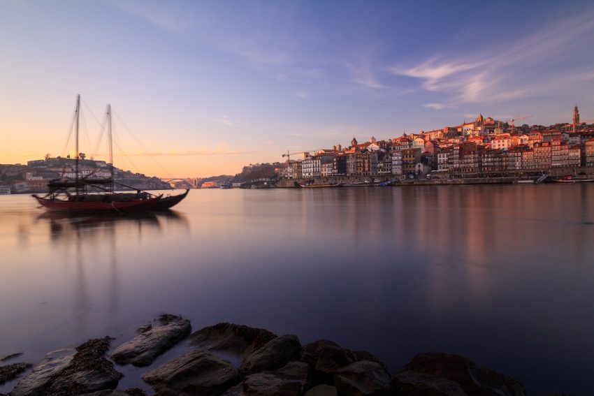
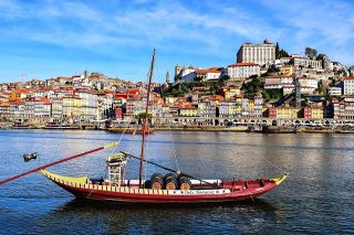
The Rio Douro, also known as the “River of Gold,” dominates the region and winds for over 200km from the Spanish border to the sea. The port wine lodges and tiny villages that dot the intricately terraced hillsides are a sight to behold. Once a wild and unpredictable river, the engineering works that followed the demarcation of the port-producing area in the 18th century tamed the rapids and opened up the Douro for trade. The railway reached the Spanish border by the end of the 19th century, and the building of hydroelectric dams and locks in the 1970s and 1980s turned the Douro into a series of navigable ribbon lakes. It is now possible to cruise all the way from Porto to Barca d'Alva on the Spanish border.
The Douro Valley and Porto both lie on the Douro River. The Porto Wine Region is famous for its production of Port, while the Douro Valley, which is situated 3 hours away from the city is renowned for its fine unfortified red and white wines.
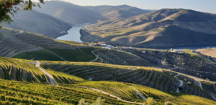
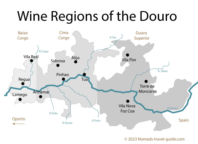
Douro Valley’s three sub regions
The Douro Valley’s unique microclimate, with hot summers and cold winters, combined with the fertile soil and careful cultivation techniques, result in some of the most outstanding wines in the world. In fact, the Douro Valley was the first officially demarcated wine region in the world, established in 1756.
Douro Wine Region is divided into three distinctive territories, from west to east that has different styles of wines and port wines:
The Baixo Corgo or Below Corgo is located around the town of Peso da Régua. It has the mildest climate and most precipitation of the three regions. It is though to give wines of lesser quality than the other two subregions.
Cima Corgo or above Corgo is the largest subregion with 19,000 hectares (47,000 acres) of vineyards, centered on the village of Pinhão, and where the majority of the famous Quintas are located.
Douro Superior or upper Douro is the hottest and driest of the subregions, and stretches all the way to the Spanish border. It has 8,700 hectares (21,000 acres) of vineyards and is the source of many wines of very good quality. As it is the least accessible of the three subregions, it is the most recently planted, and it is still expanding.
Exploring the Douro Valley by Tour
If you are visiting Porto it is quite easy to join a tour to takes you up the Douro Valley. They are usually divided into two types a tour:
You have the option to explore the region with a Group Tour that encompasses Wine Tasting, a boat Cruise, and Lunch, all for the attractive price of about €90 per person. This represents an extremely cost-effective option for budget-conscious travelers seeking an introduction to the region, and it also provides an excellent opportunity to connect with fellow like-minded explorers.
Alternatively, for a more exclusive experience featuring premium boutique wineries and the region’s finest restaurants, our Private Wine Tour in Douro Valley is the ideal choice. This option caters to those who desire a top-tier, private experience guided by a wine specialist, offering a premium level of service.
Exploring the Douro Valley by Car
If you want to explore the more remote areas of the Douro at your own pace, driving a car offers the most flexibility. The region has decent roads, which become deserted once you venture off the busy N222. However, driving within the region can be slow as the roads wind through river valleys or ascend steep hills.
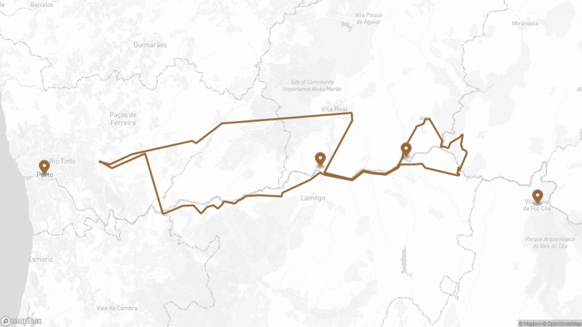
Porto to Peso da Régua: There are excellent roads connecting Porto to Peso da Régua, the main city in the Alto Douro region. From Porto, take the A4 toll expressway and then head south on the A24 to Peso da Régua. This journey takes around 1 hour and 15 minutes and allows for a day trip from Porto to visit the best parts of the Douro. Stop off here to see the Museu do Douro.
Peso da Régua to Pinhão: From Peso da Régua take the N222 to Pinhão, this is a great drive along the southern side of the river. This is a good stop off for a two hour river cruise on a traditional Rabelo boat.
Pinhão to Tua: From Pinhão, drive along the N322 which heads north through hills lined with the terraced vineyards past the village of Vale de Mendiz. This is one of the most scenic sections of the route, but unfortunately, there are not many places to stop before you reach Miradouro Vale de Mendiz viewpoint. Continue onto Alijó then head south west along the N212 towards Foz do Tua.
As you pass the village of São Mamede de Riba you enter the Parque Natural Do Vale do Tua. The parque holds the Albufeira de Foz Tua, the largest lake of the Alto Douro. The lake is actually a reservoir and was created in 2016 with the completion of the Tua dam.
Tua to Linhares: From Tua you follow N214, the road winds up towards the stunning viewpoint of Miradouro de Parambos offering breath-taking views on the way. Shortly after the viewpoint take the M633 to Linhares. This section becomes a little more rugged and wild.
Linhares to Peso da Régua: After Linhares the road drops down to cross over the Valeira dam and then enters the Douro Superior region. You rejoin the e-joins the N222 and heads westwards back to Peso da Régua along another scenic road that meanders around hills lined with the terraced vineyards. Stop at the Miradouro da Abelheira.
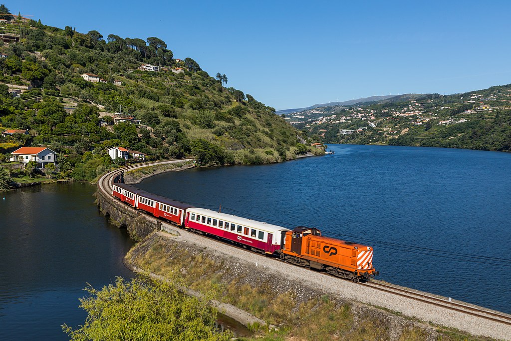
Exploring the Douro Valley by Train
The Linha do Douro is a significant railway route that offers 11 daily departures to Peso da Régua, with an additional five daily services continuing up to Pocinho. The initial part of the journey is inland, but at Pala, approximately 65 minutes into the trip, the railway follows the northern banks of the Douro, providing stunning views.
To ensure the best views during your journey, it's advisable to sit on the right side of the carriage when departing from Porto. Although the railway switches to the southern side of the river at Ferradosa, the train is usually empty by then.
The Linha do Douro train provides various options for your day trip, and the four best include heading to Pinhão, Pocinho, Peso da Régua, or Tua.
For those interested in experiencing the entire route, it’s possible to ride the train to Pocinho, which takes approximately five hours for a round trip. However, as Pocinho is only a minor town, it doesn’t have much to offer.
A much better option is to take the train to Pinhão, which takes approximately two hours and twenty minutes. Pinhão is a charming town where you can explore and join a short boat cruise that departs from the harbor, or visit the Miradouro de Casal de Loivos viewpoint.
Alternatively, there are many more daily departures to Peso da Régua, and the journey is shorter, taking about one hour and forty minutes. Peso da Régua features a lovely riverfront, and the informative Museu do Douro is situated there. Boat tours are also available from the harbour, and another option is to catch a bus from Peso da Régua to Lamego, which takes about 20 minutes.
Tua is another alternative to Pinhão, and while in the village, you can walk to the dam. However, Tua may be slightly disappointing compared to Pinhão, as the sprawling village lacks a center, and there are no boat tours.
All of these train services depart from the Campanhã train station in Porto, while a few also leave from São Bento station, which is closer to the primary tourist area. These train services are operated by Comboios de Portugal (CP), and you can find the latest timetable on their website: www.cp.pt/StaticFiles/timetables/oporto-regua-douro-regional-trains.pdf
Duoro Valley By Train
During the summer months, a heritage train that includes a classical steam train and elegant carriages runs along the Linha do Douro, providing an additional option for tourists. Details of this can be seen on the CP website: www.cp.pt.
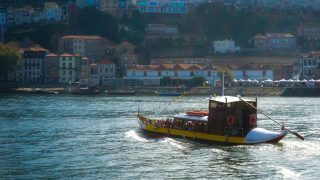
How to Explore the Douro Valley by boat
As one of the top tourist attractions, there is an abundance of boat tours and options to choose from. These range from half-day tours departing from Porto to Peso da Régua (with a return on a bus) to luxurious weeklong voyages on boats that resemble floating palaces.
The most stunning stretch of the river is the Alto Corgo (from Peso da Régua to Tua), which is flanked by terraced vineyards and steep hills. The Baixo Corgo is also beautiful, surrounded by forests and countryside that become more hilly further to the west. Heading upstream (eastwards) is the best way to take in the Douro's beauty, as the scenery continually improves. Upstream tours from Porto may cost a little bit more, but they are worth it.
Douro River By Boat
When it comes to boat tours, most tourists opt for a tour that departs from Porto and goes to Peso da Régua or Pinhão, including breakfast and lunch, and a visit to a wine-producing Quinta, with a return to Porto via a bus or the train. However, it's important to consider how long you want to spend sitting on the boat. While the scenery is breathtaking, sitting in the same seat for over 8 hours can become tiring, especially for children.
It’s worth keeping in mind that the quality of your experience is directly related to the cost. A cruise may seem like great value, but some boats can hold over 600 passengers. When booking a Douro boat tour, be sure to confirm the boat’s size and the quality of the meals.
Nomad Tip: If you plan on visiting the Douro Valley independently, we recommend taking the train to Peso da Régua and catching a boat tour from there to Pinhão, returning via train or boat. A 1-2 hour boat cruise is sufficient for most people, and smaller boats are often used for shorter trips.
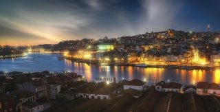
1. Porto Wine Region
View of Porto from Vila Nova de Gaia
The finest sections of the river are to the east of Porto, and the main route out of the city follows the N15 or the much faster A4 motorway to the vinho verde-producing towns of Penafiel and Amarante.
Amarante, set on the lazy tributary of the Rio Tâmega, is perhaps the most attractive town in the region, with the first of the Douro’s splendid branch train lines running up the valley here from the main-line station at Livração, about 60km from Porto.
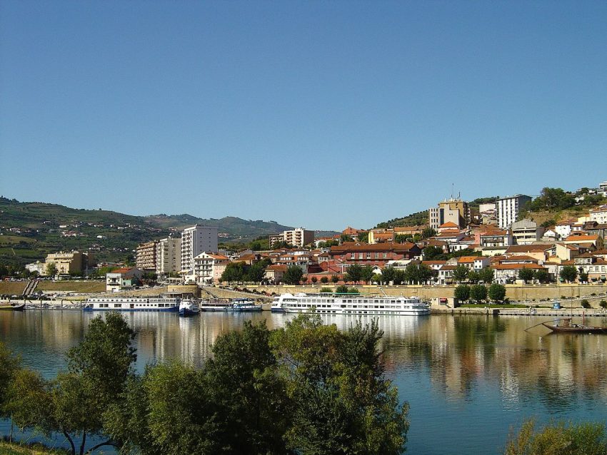
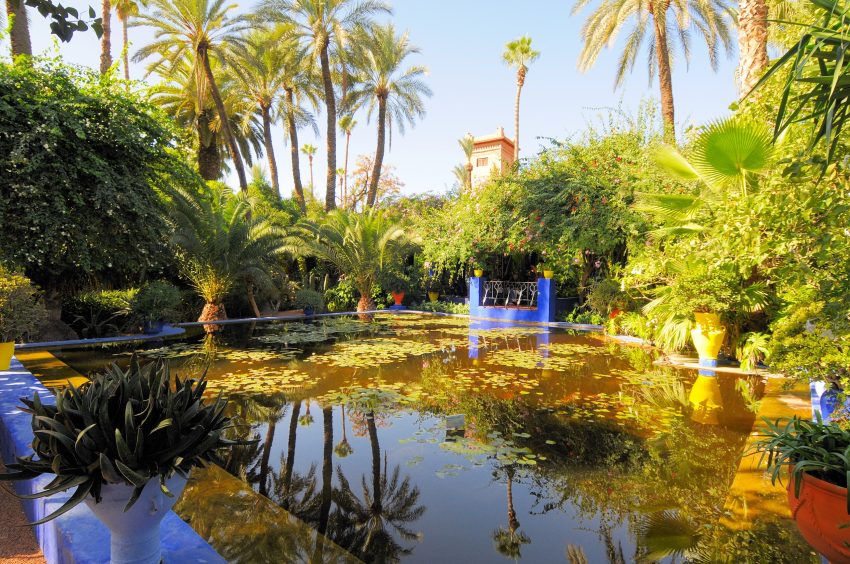
The halfway point along the river is marked by the commercial port wine town and cruise centre of Peso da Régua, the capital of Alto Douro (“Upper Douro”) province. It is surrounded by terraced hills covered in vines, resembling the backbone of a dragon. Although the town itself is not as charming as its setting, it grew into a major port-wine entrepôt in the 18th century.
The Museu do Douro is worth visiting, housed in a beautifully converted riverside warehouse, takes you through the entire wine spectrum. At the pier, you can catch frequent 50-minute boat trips to Pinhão.
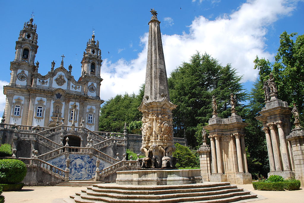
Lamego
Santuário De Nossa Senhora Dos Remédios
Just to the south of Régua, a slight detour can take in the delightful Baroque pilgrimage town of Lamego, home of Portugal’s champagne-like wine, Raposeira, and the fascinating churches, such as the Santuário de Nossa Senhora dos Remédios, and historic buildings of its little-explored surroundings.
Other sites include Lamego Castle and Lamego Cathedral.
Peso da Régua is also the starting point of the Corgo branch train line to Vila Real in Trás-os-Montes.
The best viewpoints close to Peso da Régua are the São Leonardo at Galafura and Santo António do Loureiro.
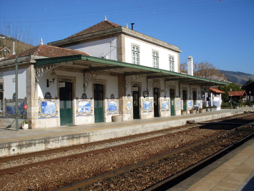
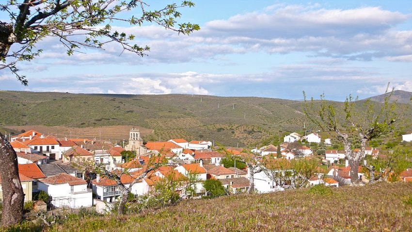
Located 25 km upstream from Peso da Régua, Pinhão is probably the prettiest town of Douro Valley, sitting on the banks of the river and surrounded by terraced vineyards. Pinhão is the best location to take a short (1-2 hour) boat cruise.
One of the main attractions of Pinhão is the historic railway station, which is adorned with traditional blue and white azulejo tiles depicting scenes from the region’s history and culture. The station is also the departure point for a scenic train journey along the Douro River, offering stunning views of the vineyards and terraced hillsides.
In addition to wine-related activities, Pinhão offers a range of outdoor pursuits such as hiking, cycling and kayaking, as well as opportunities to sample the region’s traditional cuisine, which includes dishes such as cozido, a hearty stew of meat and vegetables, and bacalhau, a salted cod dish.
Tua
Tua is a charming small village known for its peaceful and serene atmosphere, especially once you venture away from the train station complex. It is a popular destination for hiking, with a picturesque riverside footpath leading to the Tua dam
Traveling to a country with a different currency? Avoid ATM transaction fees and pay in local currency with a Wise Card. Having used it for over 5 years, we've saved loads on fees!
Douro Superior starts its dramatic mountainous landscape at the Valeira dam, its these mountains that block half the rain that comes from the Atlantic leaving the region considerably drier than the other regions leading to the name Terra Quente or hot lands.
Vila Nova de Foz Côa
This once-remote, whitewashed town has been on the map since the 1990s, when researchers, during a proposed project for a dam, stumbled across an astounding stash of Paleolithic art. It is now the Parque Arqueológico do Vale do Côa where you can admire rock art from 30,000 years ago at this open-air museum and archaeological park.
Miranda do Douro
Miranda do Douro is a fortified town situated on the edge of the Río Douro canyon, and has a long history as a stronghold in Portugal’s “wild east”. The town’s castle and 16th-century cathedral, though showing signs of wear, still exude an air of medieval grandeur. In contrast to its past, modern-day Miranda now welcomes weekend Spanish tourists instead of fending off Castilian invasions.
To gain an understanding of the region’s unique border culture, which includes traditional practices such as the “stick dancing” of the pauliteiros, one can visit the Museu da Terra de Miranda. This museum offers an insight into the customs and traditions of Miranda do Douro and its surrounding area.
This website uses affiliate links which earn a small commission at no additional cost to you.
Guimarães, a small city in the northern part of the country, is affectionately referred to as the birthplace of Portuguese state and identity as it was here that they originated in the first half of the 12th century. Its medieval historic centre, which has been well-preserved and is a designated UNESCO World Heritage Site, makes Guimarães an increasingly popular destination for day trips and weekend getaways in Portugal. The city is located just an hour away from Porto, the second-largest city in Portugal, making it easily accessible by both road and railway.
In this blog post, I will provide you with a simple self-guided tour of Guimarães. The tour will take you to the city's most well-known attractions, including the 10th-century castle that played a significant role in the establishment of Portugal, as well as the cable car that will transport you to the top of Monte da Penha, where you can enjoy breath-taking panoramic views of the lush Portuguese countryside.
By Plane: The nearest airport to Guimarães is Porto Airport (Francisco Sá Carneiro Airport), located about 40 km southwest of the city. From there, Guimarães can be reached by car, taxi, or bus in approximately 45 minutes. For the best deals and a seamless booking experience, check out these flights to Guimarães on Booking.com.
By Train: Guimarães is well connected by train from Porto. Trains depart regularly from Porto São Bento and Porto Campanhã stations, with the journey taking around 1 hour and 15 minutes. The Guimarães train station is about a 15-minute walk from the historic centre. Train schedules and bookings can be found on Omio.
By Car: If you're driving from Porto, take the A3 motorway north and exit onto the A7 toward Guimarães. The journey takes approximately 45 minutes. Public parking is available near the city centre, including at Parque de Estacionamento Largo do Toural and Parque de Estacionamento Alameda. Be mindful that some streets in the old town are pedestrian-only. If you are looking to rent a car in Portugal I recommend having a look at Discover Cars, first, as they compare prices and review multiple car rental agencies for you.
Where to Stay in Guimarães
To make the most of visiting Guimarães and this walking tour, it is best to stay overnight in or near the city centre, where you can easily access the historic streets, squares, and landmarks on foot. In the heart of the old town, Hotel da Oliveira offers a charming and convenient base just steps from the main square and the Guimarães Castle. Another central option is Pousada Mosteiro Guimarães, a historic property combining modern comfort with a location near key monuments. For a boutique experience, Hotel Fundador provides stylish accommodations in walking distance of the Palace of the Dukes and the medieval quarter.
In the surrounding area near Largo do Toural and Avenida Conde Margaride, Ibis Guimarães offers a modern and practical stay close to shops, restaurants, and public transport links. Hotel Toural is perfect for visitors wanting easy access to both the historic centre and nearby cultural attractions. For those seeking a more luxurious stay, Santa Luzia ArtHotel provides a stylish, art-focused environment while remaining within walking distance of Guimarães’ main sights.
A Brief History of Guimarães
Guimarães, often called the “birthplace of Portugal,” has a history that stretches back over a millennium. The city rose to prominence during the 10th and 11th centuries as a strategic defensive site, with Guimarães Castle at its heart, built in the 10th century to protect the region from invasions. Nearby, the Igreja de São Miguel do Castelo stands as one of the oldest churches in the city, reflecting its medieval origins. The city walls, or Muralhas de Guimarães, were gradually expanded during the Middle Ages, enclosing the historic town and providing protection for its growing population.
During the 15th century, Guimarães became a centre of nobility and administration. The Palace of the Dukes of Braganza, built in the early 1400s, served as a residence for one of Portugal's most influential noble families and is now a museum showcasing the region's history and art. Religious life flourished alongside civic development, with important churches such as Igreja de São Francisco, Igreja de Nossa Senhora da Consolação, and the Alberto Sampaio Museum, which preserves sacred art and artefacts. Public squares like Largo da Oliveira, Praça de São Tiago, and Largo do Toural became vibrant centres for trade, socialising, and civic gatherings.
In the modern era, Guimarães has embraced cultural preservation alongside urban development. The Centro Cultural Vila Flor serves as a hub for contemporary arts, while the Martins Sarmento Society promotes the study and conservation of the city's rich archaeological heritage. Streets such as Rua de Santa Maria wind through the medieval centre, offering a glimpse into the past, while viewpoints like Monte da Penha provide panoramic views of the city and surrounding landscapes. Today, Guimarães remains a living testament to Portuguese history, where medieval architecture, cultural institutions, and charming streets converge for visitors to explore.
Guided or Self-Guided Tour of Guimarães?
While Guimarães is easily navigable on your own, a guided tour can provide deeper insights into its rich history and hidden gems. The Guimarães Flexible Walking Tour in Historic Center offers a comprehensive exploration of the city’s landmarks. Covering a 3.5 km route, this tour takes approximately 3 to 4 hours and includes over 40 points of interest, such as the Guimarães Castle, Dukes’ Palace, and the scenic Footpath on the Walls of Guimarães.
Your Walking Tour of Guimarães
This guide highlights Guimarães’s key attractions, but depending on your interests and pace, you might choose to delve deeper into specific areas or indulge in the city’s renowned culinary scene.
1. Centro Cultural Vila Flor
Centro Cultural Vila Flor
CC BY-SA 2.5 / Spicka
Arriving by Car: If you are arriving by car, the Centro Cultural Vila Flor is great for parking. You can park for the whole day at the paid parking lot of Centro Cultural Vila Flor. If you are coming off season then you can park by the castle. Arriving by Train: The train station is also just a few steps away. Leaver the train station, turn left, along Av. Dom João IV, and first right along Av. Dom Afonso Henriques to get to the Centro Cultural Vila Flor.
Enjoy strolling around the gardens of this historic house with their flower beds bordered by boxwood with a wide variety of shrubs and ornamental herbaceous species. Look for the ponds and fountains in the centre, which are surrounded by garden terraces.
Head back to Av. Dom Afonso Henriques and turn right to walk along it until you reach Largo do Toural.
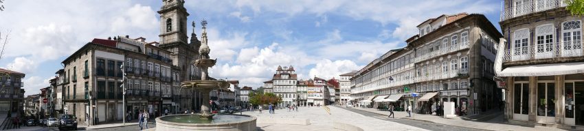
Largo do Toural is a central square located in Guimarães, which serves as a gateway to the city’s medieval historic center. A large fountain sits at the heart of the square, while the Church of São Pedro stands on one side, and a long wall of tall buildings on the other. These buildings have facades composed of seemingly endless rows of elongated windows with narrow strips of wall covered in traditional Portuguese tiles, known as azulejos. This gives Largo do Toural an elegant look and feel.
Here, you will see the iconic sign “Aqui nasceu Portugal” (meaning “Portugal Was Born Here”) affixed to a portion of the medieval defensive wall. This proudly proclaims the fact that the County of Portucale became the independent Kingdom of Portugal in the first half of the 12th century, right here in the city of Guimarães.
Several small eateries and traditional shops can be found around Largo do Toural, making it a great place to stop and get breakfast, a snack, coffee, or water. Additionally, there are several pharmacies in the area where you can find last-minute essentials such as hand sanitizer or tissues.
Here is a complete selection of hotel options in Guimarães. Feel free to review each one and choose the stay that best suits your needs.
3. Martins Sarmento Society
Soc Martins Sarmento
CC BY-SA 4.0 / Manuelvbotelho
120 meters from the north end of Largo do Toural, the Museum of the Martins Sarmento Society.
The Museum of the Martins Sarmento Society holds the distinction of being the oldest archaeological museum in Portugal. Housed in an exquisite neoclassical edifice, the museum features the Gothic cloister of the former Monastery of São Domingos. Visitors can look forward to an extensive collection of thousands of Celtic and Roman artefacts, with a particular focus on the excavations of Citânia de Briteiros, a Celtic hill-fort that saw occupation by various cultures through the Middle Ages. Located approximately 15 kilometers from Guimarães, the museum is a must-visit destination for history buffs.
Traveling to a country with a different currency? Avoid ATM transaction fees and pay in local currency with a Wise Card. Having used it for over 5 years, we've saved loads on fees!
4. Squares of Guimarães
Casa e Largo dos Laranjais
CC BY-SA 2.0 / José Antonio Gil Martínez
Starting at the north end of Largo do Toural, retrace your steps and head northward towards Rua de Santo António. This long street is lined with fancy boutiques and boasts facades covered in beautiful azulejos. From Rua de Santo António, walk northeast for approximately 110 meters, then turn right onto Rua Val de Donas.
As you enter the historic centre of Guimarães, you’ll notice an array of houses and buildings in various styles. Each structure reflects the passage of time and the architectural changes that have taken place throughout the centuries. Taking a leisurely stroll down the street, you’ll come across charming small balconies with wrought-iron railings, blooming potted plants, and cobbled lanes. The ambiance is nothing short of magical, and it’s quite enjoyable to take your time soaking it all in.
The first square you will come to is the Fonte do Largo Dr. João da Mota Prego, with a couple of olive trees, fountain and an aromatic lavender plantation. As you enter the square you pass the Casa das Rótulas, possibly built in the first half of the 19th century. Its use of wooden railings placed on the upper balcony is typical of houses in the north of Portugul built from the end of the sixteenth century.
Continuing along Rua Val de Donas you to get to the Largo dos Laranjais or the Square of the Orange Trees. Again this is a small rectangular square, this time with orange trees at its centre and overlooked by a tall medieval tower – Casa dos Laranjais.
Leave the square along the Rua das Trinas and you will come to Jardim do Carmo or Gardens of Carmo. At the start of the gardens is a bust to Martins Sarmento, the archaeologist from Guimarães who lived in the square. It was a group of his admirers, who created the Sociedade Martins Sarmento in 1882 (see above).
On the right is the Church and Convent of Nossa Senhora do Carmo, built in the 17th century in Baroque style, deserves a visit inside. On the left a chain of palatial houses. Look for the houses with some with coats of arms on the front, of the nobles who once lived there.
You are now climbing onto the small hill of Monte Latito which is also widely known as Colina Sagrada – the Sacred Hill of Portugal. The hill holds three monuments to the founding of Portugul: Castle of Guimarães, Church of São Miguel and the Palace of the Dukes of Bragança.
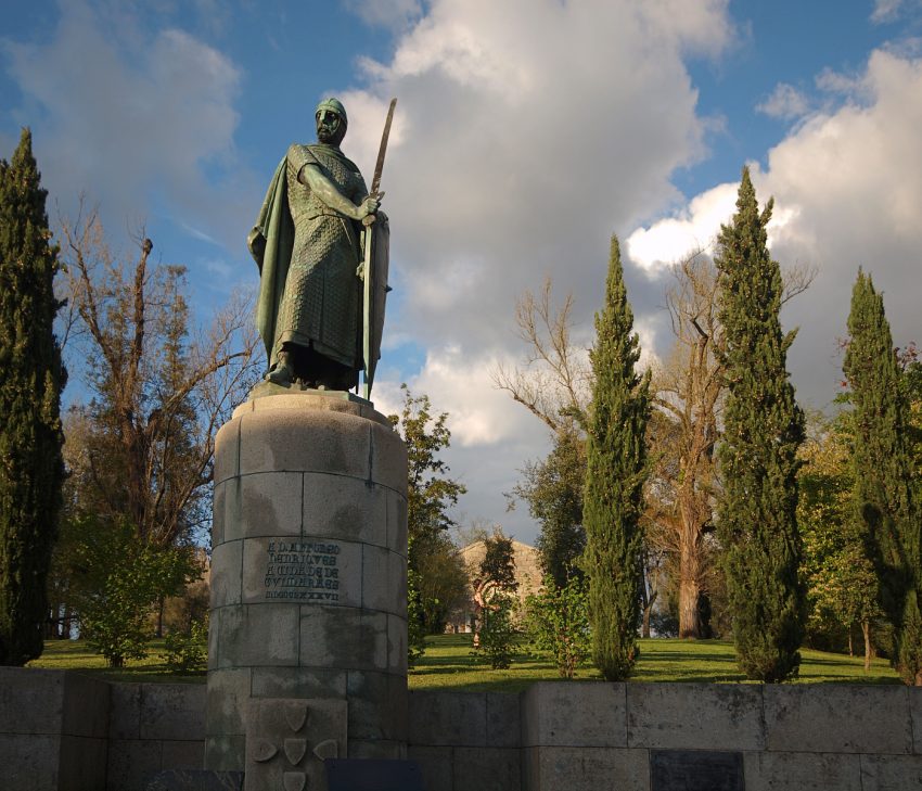
At the top of the hill you sill see the Statue of D. Afonso Henriques the founder of Portugal. The statue shows the Conqueror King is depicted in a warlike stance, holding a sword and shield with both hands on a bronze statue raised on a granite pedestal. This is an iconic statue in the country and one of the most well-known images of the founder of Portuguese nationality.
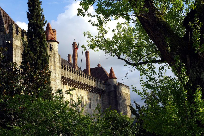
Behind the statue is the Church of São Miguel and to your left the Palace of the Dukes of Bragança.
Head back to the Palace of the Dukes and purchase a ticket to see the Palace and the Castle (€6.00).
Construction of the estate around 1420 was initiated by Dom Afonso, the first Duke of Braganca. However, the family eventually moved to a different location, and the palace was left to deteriorate until it fell into ruins by the mid-17th century. In 1910, the palace was declared a National Monument and extensive restoration work was carried out, drawing inspiration from other medieval palaces of the period.
One of the palace wings currently serves as an official residence for the Presidency, and visitors can admire the palace’s stunning private chapel, banquet hall with a chestnut ceiling modeled after the upturned hull of a Portuguese caravel, and an impressive collection of tapestries, rugs, paintings, furniture, ceramics, and weapons. The palace’s official website provides detailed information about the collection.
Visitors can choose to explore the palace on their own or as part of a guided tour, with a recommended hour for the visit. It is advisable to purchase a joint ticket that includes both the castle and the palace.
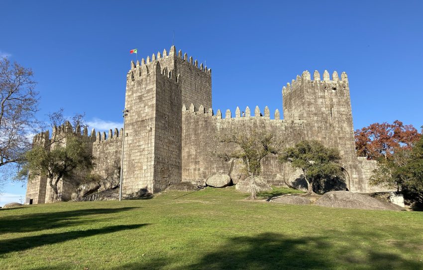
Guimaraes Castle, located on the hill of Monte Largo, is widely regarded as the birthplace of Portugal as it was where the first king of Portugal, Afonso I the Great, was born in 1109. 19 years later, he won a crucial victory near Guimaraes over the troops of his mother, Teresa, thereby freeing Portugal from its dependence on Leon and Castile.
Interestingly, the fortress on this site has been in existence since the seventh century during the Visigoth era. It was built on the orders of the Countess of Portugal Mumadona Dias in the tenth century to protect against threats from the Moors to the south and Vikings from the sea. This order, dated December 958, still exists today. The castle was originally composed of a single donjon surrounded by a defensive wall.
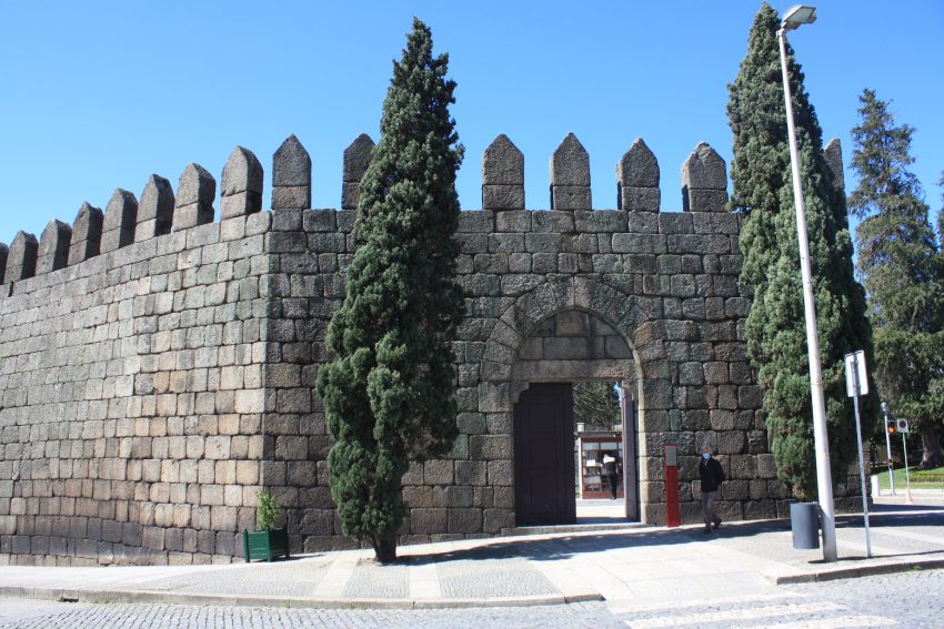
In the 14th century, the entire village was surrounded by a 2 km defensive wall, and access to the castle was controlled by eight 28-meter towers with gates. However, today, only the eastern 1-km section with four towers and several gates of the old city wall remains. A suspended wooden bridge connects the western wall and the central gate.
Head behind the castle towards the carpark and follow the road along the outside of the ramparts. You come to a large open area infront of the courthouse. There is a statue to the Countess Mumadona Dias, who jointly governed the County with her husband from the year 920. After the death of her husband around 950, she ruled alone until his death in 968. To the rights of the courthouse is the area of the city walls that you can walk along.
You can see one of the of city gates and walk along the top of the old walls for a short distance, and it is a pleasant way to survey a part of the town.
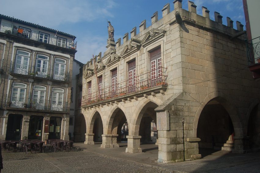
Head along Rua de Nuno Álvares until you reach a small square and the Rua de Santa Maria. On the one side of the square is the intricate Baroque facade of the Convento de Santa Clara, which is now the Town Hall – if you can have a look around the cloisters.
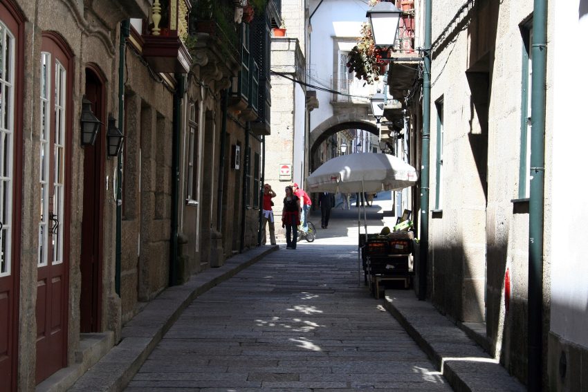
Dating back hundreds of years, Rua de Santa Maria is a long street named after St. Mary that served as a crucial connection between the Castle of Guimarães and a wealthy convent dedicated to Santa Clara.
As you stroll down Rua de Santa Maria, you’ll come across numerous exquisite historic buildings and charming shops selling locally made souvenirs.
Additionally, this street is where you can sample some of Guimarães’ famous pastries and sweets, including toucinho-do-céu, tortas de Guimarães, and douradinhas de Guimarães. These delicious treats are made by hand using recipes passed down from centuries-old convents.
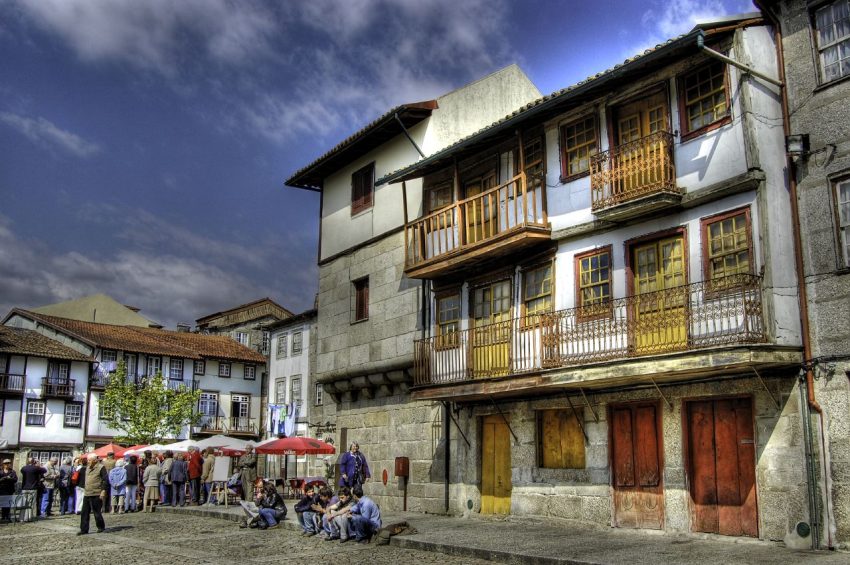
Further down Rua de Santa Maria, you’ll discover one of the most picturesque historic squares in Guimarães – Praça de São Tiago. This idyllic square is adorned with colourful facades and cobblestones, and it’s dotted with local restaurants where you can savour delicious food while enjoying the charming surroundings.
If you continue walking down Rua de Santa Maria, you will soon reach one of the most charming and historic squares in Guimarães, known as Praça de São Tiago. This picturesque square is a vision of vibrant facades that encircle a cobbled expanse, dotted with tables from the nearby restaurants.
According to tradition, an image of the Virgin Mary was brought to Guimarães by the apostle S. Tiago, and placed in a pagan Temple in a square that came to be called Praça de S. Tiago. Quite an old square, referred to over time in various documents, still retains its medieval features.
It was in its vicinity that the Franks who came to Portugal in the company of Count D. Henrique settled.
There was a small porched chapel from the 17th century. XVII dedicated to Santiago that was demolished at the end of the century. XIX.
Either continue down the Rua de Santa Maria or head south from Praça de São Tiago, under the vaulted arcade to reach another exquisite square, Largo da Oliveira.
A really lovely old square in the centre of Guimaraes with the most beautiful buildings surrounding it, with the eponymous olive tree and a small open Gothic chapel in the centre.
Antigos Paços do Concelho: The medieval town hall, Antigos Paços do Concelho, stands above the vaulted arcade that separates Praça de São Tiago from Largo da Oliveira. Built between the 14th and 15th centuries, this historic building is crowned with the statue of a warrior.
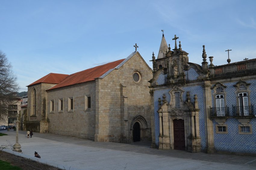
Church of Nossa Senhora da Oliveira: One of the oldest churches in Guimarães, the Church of Nossa Senhora da Oliveira, has a history dating back to the 10th century. It was an important site of prayer and religious pilgrimage during the Middle Ages.
Padrão do Salado: The Padrão do Salado is a 14th-century arched monument that covers a raised cross. It was erected in commemoration of the Battle of Rio Salado in 1340, when the armies of Spain and Portugal stopped the invasion of the Iberian peninsula by the sultan of Morocco.
Head past Arches of Padrão do Salado south along Rua Alfredo Guimarães, keeping the Church of Nossa Senhora da Oliveira on your left.
The Alberto Sampaio Museum, founded in 1928, is housed in three spaces – Chapter House, Cloister, and Priory – that once belonged to the adjacent Church of Nossa Senhora da Oliveira. The museum features eight rooms and several thematic clusters with objects from the 12th to the 19th centuries.
13. Igreja de Nossa Senhora da Consolação (Guimarães)
Igreja de Nossa Senhora da Consolacao e Santos Passos
CC BY-SA 2.0 / xlibber
Head south from the Alberto Sampaio Museum and you will see the stunning view of the Igreja de Nossa Senhora da Consolação.
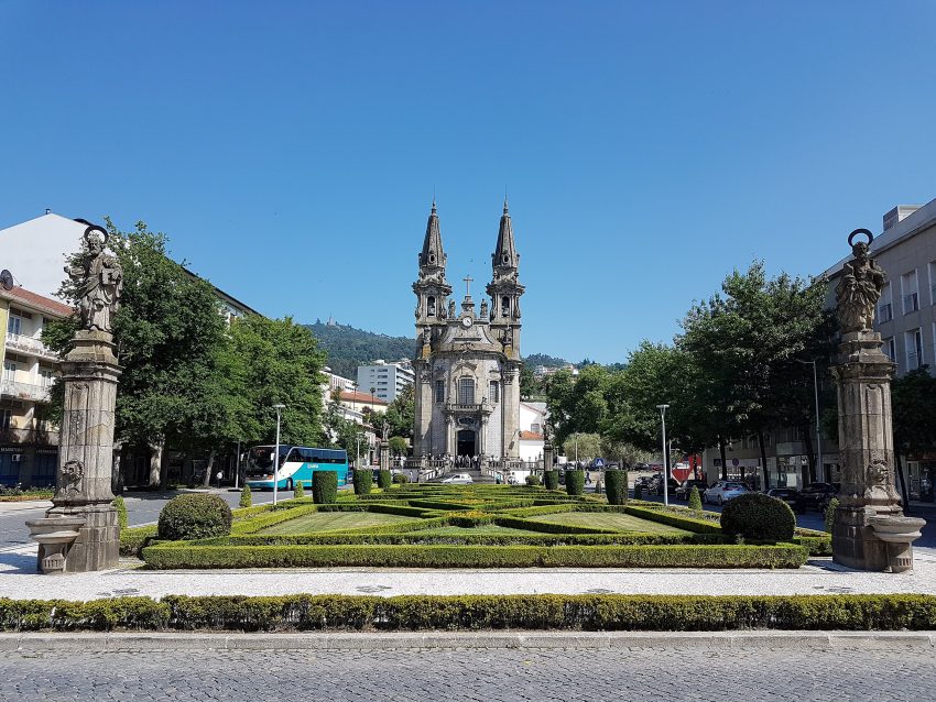
You can see the iconic landscaped garden of Largo da República do Brasil. With an eruption of seasonal blooms contained between geometrical lines formed by beautifully trimmed shrubs, the garden leads the eye down to a thin tall church dating back to the 18th century, the Igreja de Nossa Senhora da Consolação.
To get from the Igreja e Oratórios da Nossa Senhora da Consolação e Santos Passos to Penha Cable Car, also known as Teleférico de Guimarães, it’s a short walk of about 450 m. From Largo de São Brás, turn right onto Rua Dr. Ricardo Marques, then after 74 m, turn right onto Rua do Rei Pegu. Continue straight for 190 m, take a slight left across Jardim do Lugar das Hortas, and after about 100 m, you will arrive at the station of Penha Cable Car.
This cable car is said to be the oldest in Portugal and has been operating since 1995. Its cabins are small, and the entrance door is narrow, so be careful with loose clothing and keep your bag in front of you as you board the cabins, which move slowly forward.
Penha Cable Car has seasonal opening hours and is closed for most of the week during the low season (click on the button below for more details).
The cable car will take you to the top of Monte da Penha, which is 617 m high. The journey spans over 1,500 m and takes a few minutes. As you approach the top station of the cable car, you’ll see the Sanctuary of Penha, a modernist-style structure built between the 1930s and the 1940s that is well worth a visit.
Around the sanctuary, there is a beautiful nature park with hiking trails, picnic areas, panoramic viewpoints, grottoes, monuments, and even a camping area. The park is dotted with enormous mossy boulders that give it a surreal and magical feel. It’s a great place to escape on a hot day and relax in the shade of the trees while taking in the splendid views.
When you’re ready to head back down to the city, you can take a return journey on Penha Cable Car.
Location: Penha, Guimarães, Portugal | Hours: Winter: Open Fridays, Saturdays, Sundays 10 am - 5:15 pm | Price: Adults €7.50, Children €3.50.
From the bottom of the cable car, return to the Igreja de Nossa Senhora da Consolação and walk halfway down the Largo da República do Brasil, and turn left onto Rua Padre Gaspar Roriz.
Next, you’ll come across the grand edifice of the Church of São Francisco. Its stunning interiors boast magnificent blue and white azulejos, and meticulously crafted wood carvings embellished with delicate gold leaf.
However, it’s important to note that the Church of São Francisco typically closes its doors at 5 pm. If you wish to marvel at its beauty, you’ll need to efficiently manage your time while exploring the other attractions on this one-day tour of Guimarães.
Finally head back to the Train Station or car park. Hope you enjoyed our self guided walking tour of Guimarães!
A Self-Guided Walking Tour of Braga, Portugal (2026)
braga Things to do
This website uses affiliate links which earn a small commission at no additional cost to you.
Braga, often called the “Portuguese Rome,” is a city where centuries of history, religion, and culture are woven into the streets, squares, and hillsides. Known for its impressive baroque architecture, grand churches, and vibrant public spaces, Braga offers a walking tour experience that immerses visitors in both its spiritual and civic heritage. Exploring the city on foot allows you to fully appreciate its rich layers, from the medieval streets of the historic centre to the panoramic views atop its famous sanctuaries.
The city is home to some of Portugal's most significant religious sites, including the Bom Jesus do Monte sanctuary with its striking staircase and the Braga Cathedral, which reflects a mix of Romanesque, Gothic, and Baroque styles. As you wander through the city, you'll encounter charming plazas, ornate fountains, and centuries-old streets lined with traditional shops and cafes, making every step a journey through Braga's history and culture.
A walking tour of Braga also offers a chance to experience the lively local life. From bustling markets to quaint cafés and the peaceful gardens that dot the city, visitors can enjoy both the energetic urban atmosphere and the serene corners of this historic city. By exploring on foot, you can move at your own pace, discovering hidden gems while taking in the architectural beauty and cultural richness that make Braga a unique destination in northern Portugal.
By Plane: The closest major airport to Braga is Porto Airport (Francisco Sá Carneiro Airport), located about 50 km southwest of the city. From there, you can reach Braga by train, bus, or taxi in roughly 45-60 minutes. For the best deals and a seamless booking experience, check out these flights to Braga on Booking.com.
By Train:Braga is easily accessible by train from Porto, with frequent regional services taking just over an hour. The train station is about a 15-minute walk from the city centre. Train schedules and bookings can be found on Omio.
By Car: If you're driving from Porto, take the A3 motorway northbound-Braga is about 50 minutes away. Parking can be found at Campo da Vinha or Avenida Central, both near the historic centre. If you are looking to rent a car in Portugal I recommend having a look at Discover Cars, first, as they compare prices and review multiple car rental agencies for you.
Where to Stay in Braga
To make the most of visiting Braga and this walking tour, it is best to stay overnight in or near the city centre, where most of the historic sites, squares, and churches are within easy walking distance. In the heart of Braga, Hotel Bracara Augusta offers modern comfort with a convenient location close to the cathedral and old town streets. Another excellent option is Vila Galé Collection Braga, a stylish hotel near the historic centre and a short walk from the Avenida da Liberdade. For a charming boutique experience, Moon & Sun Boutique Hotel provides a cozy, central base ideal for exploring the winding streets and plazas.
In the area around Avenida Central and Campo das Hortas, Hotel do Parque offers comfort and easy access to the main attractions while being slightly removed from the busiest streets. Aparthotel Bracara Augusta is perfect for those who prefer apartment-style accommodation in the centre. For a more upscale experience, Hotel Mercure Braga Centro provides modern amenities and is just minutes from Braga Cathedral and the historic squares.
A Brief History of Braga
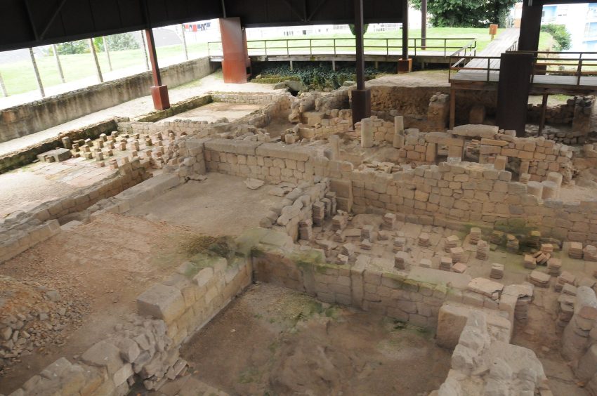
Braga, one of Portugal's oldest cities, has a history that stretches back over 2,000 years. Originally founded by the Romans as Bracara Augusta in the 1st century BC, it quickly became an important administrative and religious centre in the region. Evidence of this Roman heritage can still be seen today in sites such as the Roman Thermae of Maximinus, which showcase the city's ancient public bathing culture, and the Fonte do Ídolo, an intricately carved fountain dedicated to local deities. The Museum of Archaeology D. Diogo de Sousa preserves many of these artifacts, providing a window into Braga's early Roman past.
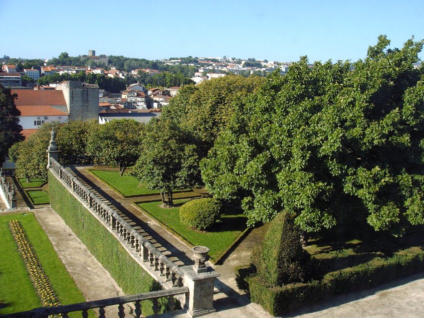
Throughout the Middle Ages, Braga emerged as a key ecclesiastical centre and was often referred to as the “Portuguese Rome.” The city's religious significance is highlighted by the imposing Cathedral of Braga, built over several centuries, combining Romanesque, Gothic, and Baroque elements. The Episcopal Palace and its surrounding gardens, including the Jardim de Santa Bárbara, reflect the wealth and power of the archbishops who shaped the city's medieval and early modern development. During this period, Braga also saw the construction of defensive structures like the Torre de Menagem, protecting the city and symbolising its enduring strategic importance.
In the 18th and 19th centuries, Braga continued to expand and modernize while retaining its historical character. Notable buildings from this period include the Palácio do Raio, a striking example of Baroque architecture, and the Biscainhos Museum, which showcases aristocratic life in Braga. The Arco da Porta Nova and Praça da República became iconic urban landmarks, linking Braga's Roman, medieval, and modern layers. Museums such as the Pius XII & Medina Museum preserve the city's rich art and religious history, making Braga a city where centuries of cultural, religious, and civic development can be explored on foot.
Guided or Self-Guided Tour of Braga?
While Braga’s compact layout makes it ideal for self-guided exploration, a guided tour offers valuable insights into its layered history. The Explore the Portuguese City of Braga Tour leads visitors through the city's most iconic sites. You'll discover the Braga Cathedral, the Arco da Porta Nova, Santa Barbara Gardens, and hidden Roman ruins-all brought to life by a knowledgeable local guide.
Your Walking Tour of Braga
This guide highlights Braga’s essential sites, but the joy of walking here is in the details-shaded courtyards, hidden fountains, and quiet cloisters just waiting to be discovered.
1. Museum of Archeology D. Diogo de Sousa
Museu Dom Diogo de Sousa
CC BY-SA 4.0 / Joseolgon
Free parking is available at Altice Forum Braga (R. Monsenhor Airosa, 4705-002 Braga, Portugal).
From here walk north along R. Monsenhor Airosa, cross the N103 carefully and turn left and first right.
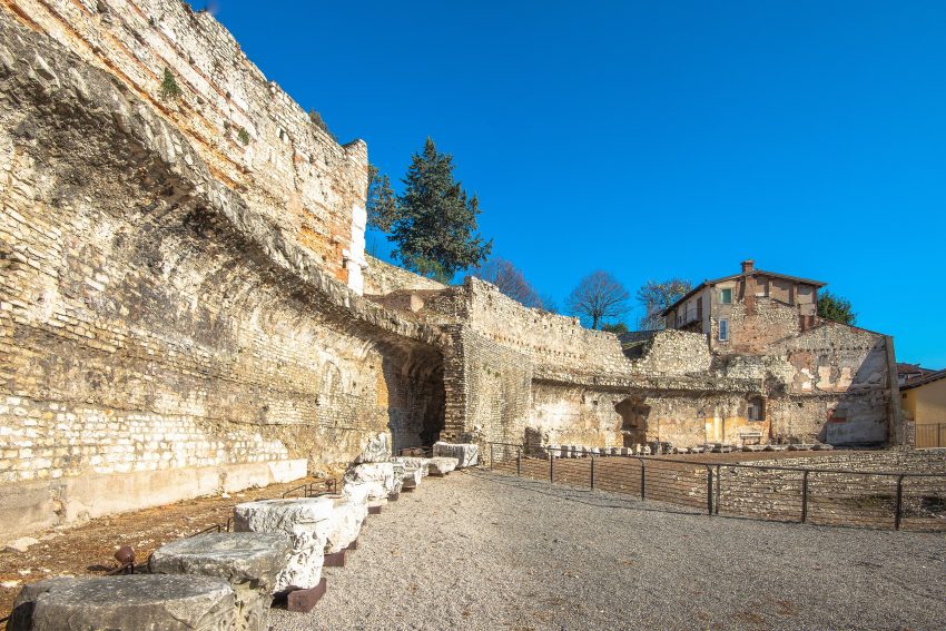
You will pass the Ruína do Aqueduto Romano, which look like a modern representation of the roman aqueduct located here.
Just beyond this on your left is the Museum of Archeology.
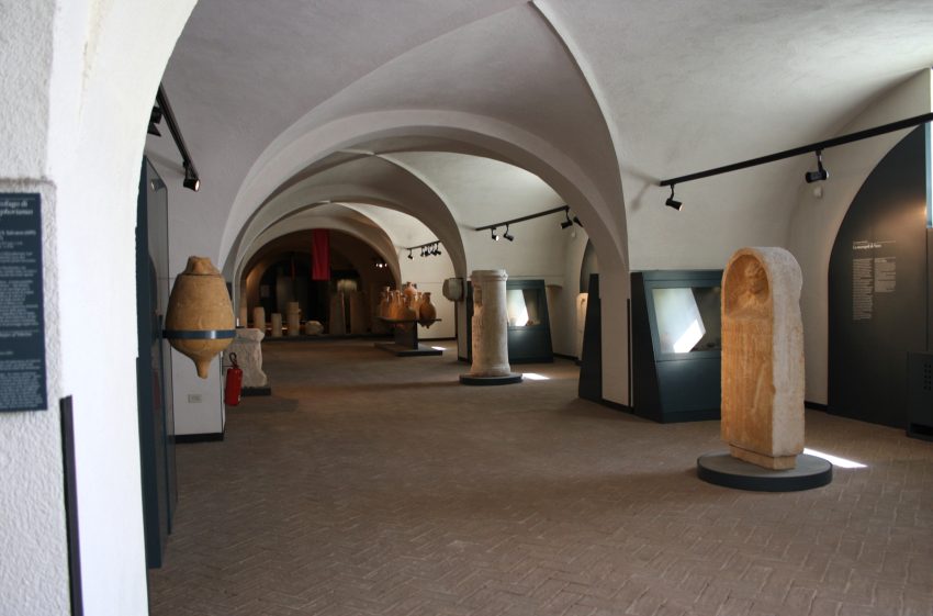
The Museum of Archeology D. Diogo de Sousa was created in 1918, the D. Diogo de Sousa Regional Museum was revitalized in 1980 as the Museum of Archaeology (Museu de Arqueologia). Its collections consist primarily of artifacts from archeological investigations conducted in the North region, with a particular emphasis on the city of Braga. Its collection spans a broad range of chronological and cultural periods, from the Paleolithic era to the Middle Ages.
The permanent exhibition is divided into four main sections. The first section covers the Paleolithic, Mesolithic, Neolithic, Chalcolithic, Bronze Age, and Iron Age periods. Geographically, the collections in this section originate from the Minho region. The collections in the other rooms, on the other hand, are from Bracara Augusta and its surrounding territory.
From the museum, carry on north and turn the first left. This is signposted “Ruinas Romanas de Cividade”.
The museum is spacious and impressive, showcasing numerous pre-Roman and Roman artefacts. However, the excavation of the actual Roman baths was not well-marked and underwhelming, with no signage to guide visitors. If it weren’t for the expensive disabled seat rail mover, I wouldn’t have even ventured into the basement area where the baths were located. While the excavated area did contain some mosaic flooring, it was quite small compared to other similar sites, such as those found in olive groves in the Alenteju, which boast Olympic-sized baths.
The site could do with more detailed information about individual artefacts and items on display.
Here is a complete selection of hotel options in Braga. Feel free to review each one and choose the stay that best suits your needs.
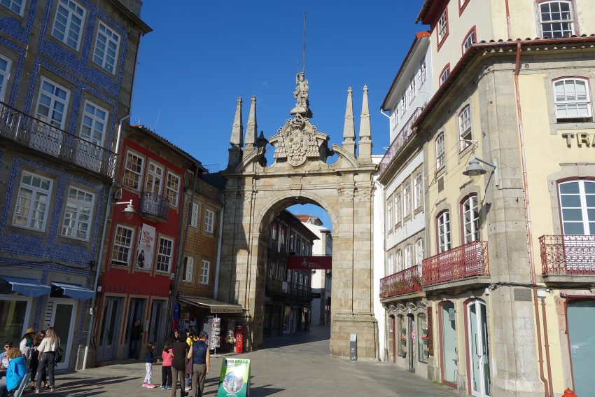
3. Arco da Porta Nova
1024px Arco da Porta Nova Braga
CC BY-SA 2.0 / FlyingCrimsonPig
From the baths turn left and walk along R. Dr. Rocha Peixoto, at the crossroads, straight across onto R. do Matadouro. The third turning on your left you will see the Arco da Porta Nova.
The Arco da Porta Nova or Arch of the New Gate, is an ornamental gateway leading into the historic centre of Braga from the west. Located on the pedestrianised Rua do D. Diogo de Sousa, it was constructed to a design by architect André Soares in the 1770s, although a gate has stood in its place since the city walls were completed in the late 1300s.
Traveling to a country with a different currency? Avoid ATM transaction fees and pay in local currency with a Wise Card. Having used it for over 5 years, we've saved loads on fees!
4. Biscainhos Museum
Biscainhos Garden
CC BY-SA 4.0 / Joseolgon
As you are facing the arch turn 90 degrees to your left and walk down R. dos Biscaínhos to reach the museum.
The Biscainhos Museum is located in a 16th century manor house. The museum has a permanent collection of furniture, ceramics, glass and clocks displayed in situ to recreate the décor of an 18th century manor house.
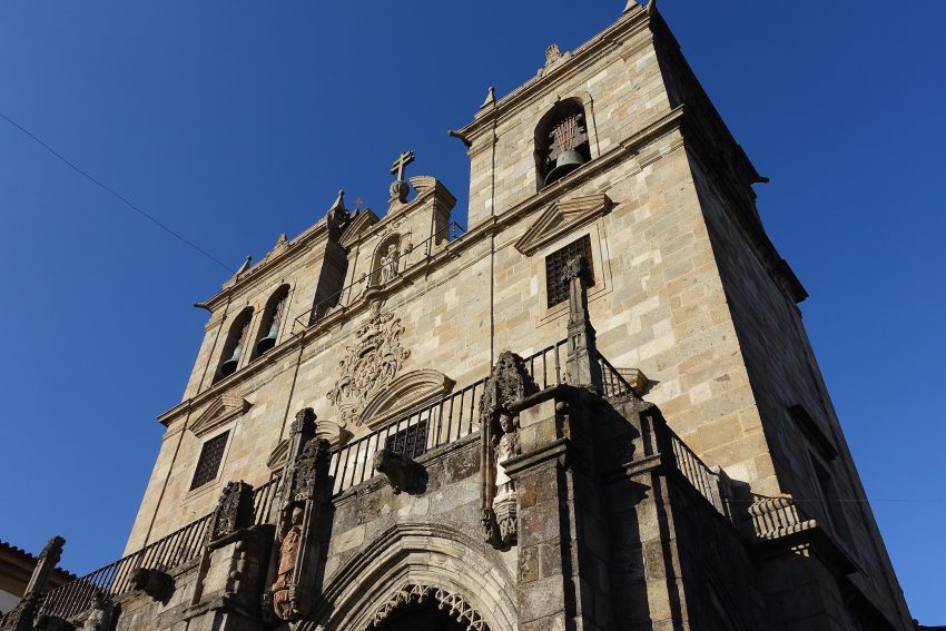
Head back to the arch, and walk under it along R. Dom Diogo de Sousa to the Cathedral.
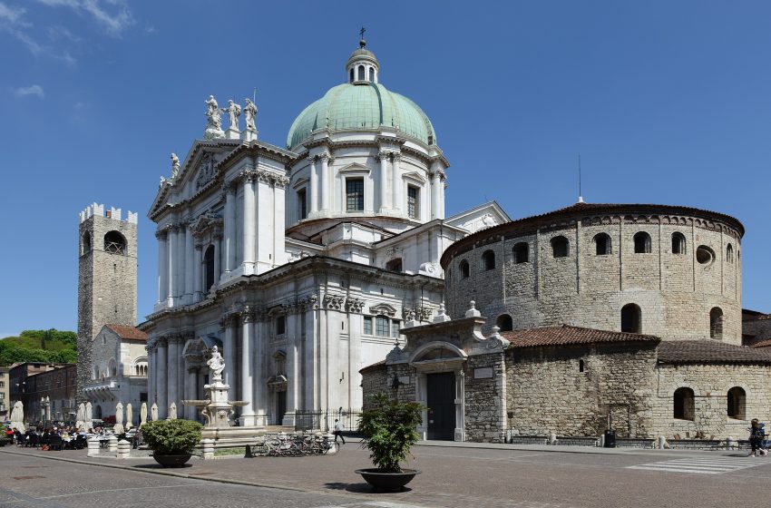
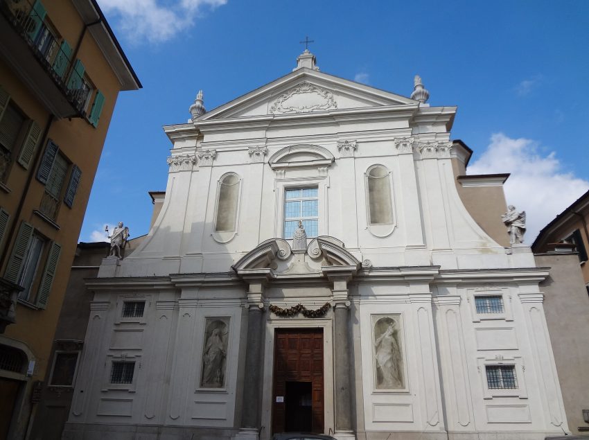
Braga Cathedral, situated in the heart of the historic center, holds the distinction of being the oldest cathedral in the country. Built during the 11th century, it underwent numerous restorations and expansions in the following centuries. Its architecture is an eclectic mix of various styles, including Romanesque, Gothic, Moorish, Manueline and Baroque, each of which reflects its long and storied past.
The cathedral is adorned with richly decorated chapels, gilded features, and an absolutely magnificent baroque organ, which is one of Captain Ulysses’ favorite sights in Portugal.
But the city of Braga boasts many other religious buildings that are worth visiting, such as the Igreja de Santa Cruz, Igreja da Misericordia, Igreja de Sao Marcos, Basilica dos Congregados, and Igreja e Convento do Populo.
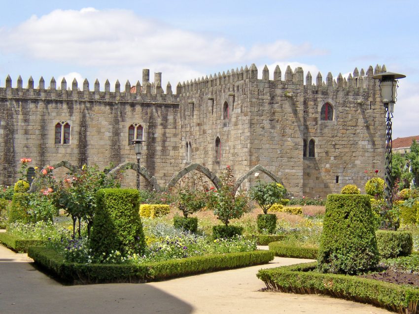
Continue along the R. Dom Diogo de Sousa and you will see the Archbishop’s Palace on your left.
The former Archbishop’s Palace is a stunning sight, with its toothy crenelated walls providing a dramatic contrast to the lush greenery of the adjacent Jardim de Santa Bárbara.
Walking past the Archbishop’s Palace and turn first left onto R. Dr. Justino Cruz to get to the gardens.
What made the Garden of Santa Barbara special was its setting – the medieval Episcopal Palace loomed majestically in the background. Incorporating the arches of a wing that was tragically burned down in 1834, the gardens seamlessly merged with the palace’s stunning architecture.
Dating back to the 14th century, the medieval section of the Episcopal Palace was visible from the Garden of Santa Barbara, while later extensions showcased equally enchanting architectural styles.
The palace is open to the public free of charge and serves as a home for various municipal and university facilities. Its location in the heart of the old town makes it a must-visit destination for anyone exploring Braga. Don’t miss out on the opportunity to experience the beauty of the Gardens of Santa Barbara and the grandeur of the Episcopal Palace.
Continue on R. Dr. Justino Cruz and turn first right R. dos Capelistas, a nice pedestrianised street, at the end of which just before you reach the Praça da República is the Torre de Menagem.
The Torre de Menagem, a crenellated tower with a square shape located behind the cafes on Praça da República, is the only remaining piece of a fortified medieval palace. The tower is now walled-up and serves as a reminder of the city’s rich history.
Continue to the direction you were heading on the R. dos Capelistas to reach the Praça da República.
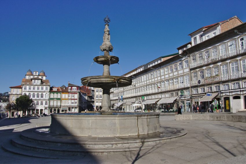
Like other squares of the same name, Praça da República (Republic Square) is one of the most significant public spaces in Braga, continuing the Portuguese tradition. Situated on the western side of the city’s historic centre, it buzzes with activity from mid-morning until late into the evening, attracting locals who come to relish a meal at the numerous cafes and restaurants that grace the square. Stop and have a coffee at the terrace of one of the two emblematic centennial cafés of the city: Café Vianna and Astória.
From the The Praça da Republica head south along the large pedestrianised avenue. Pass the Theatro Circo on your right and turn right after the next block. On the opposite side of the road is the entrance to Fonte Idolo, which looks like a subway entrance.
Concealed behind a contemporary lobby and nestled below street level lies a remarkable hidden gem – an ancient spring that offers a glimpse into Braga’s rich past. This evocative spring was once an essential source of water for the community during the city’s early days.
Carved into a fountain during pre-Roman times by Celicus Fronto, an immigrant from the city-state of Arcobriga, the spring and its surrounding rock face are a testament to the skilled craftsmanship of ancient civilizations. One of the carvings portrays a toga-clad pilgrim who is believed to be holding the Horn of Plenty.
Visitors can learn about the spring’s fascinating history through an introductory video that provides valuable insights into this remarkable attraction. Whether you’re a history buff or simply seeking a unique experience in Braga, this ancient spring is not to be missed.
As you come out of the Ídolo Fountain turn left and the Palácio do Raio is in front of you.
The Palácio do Raio or Braga’s Raio Palace, was built in the 1750s as the private home of João Duarte de Faria. Although Faria had made considerable wealth as a merchant, he was also a Knights Templar. It was constructed in the late Baroque style by André Soares, an architect who had already made a name for himself as a leading champion of the northern baroque school. His other works within the city include the town hall, Church of Congregados, and Arco da Porta Nova ornamental city gateway (see above). A large part of the two-storey façade is covered in traditional blue and white azulejo tiling.
As you leave Palácio do Raio turn left. The square you enter is called Largo Carlos Amarante with a large fountain in the middle of it. Wlak directly opposite and leave the square by the Igreja de Sta. Cruz, along the R. do Anjo. As you enter the Largo de Santiago you reach the Museum. In front of the museum is a replica Roman milestone.
Archeological exhibits including Palaeolithic, Neolithic and Bronze age implements, Pre-historic and Luso-Roman pottery. Museum also features part of a Roman Villa in the original location.
Location: Museu Pio XII, Largo de Santiago, Braga, Portugal | Hours: From Tuesday to Saturday, from 9:30 a.m. to 12:30 p.m. and 2:30 to 6 p.m.
The Museum is closed on Mondays. As well as on 25 December, 1 January and Easter Sunday. | Price: Medina Gallery visit: 2€ Medieval Tower visit: 2€ Entire Museum visit: 4€ | Website
Best Trips from Marrakesh, Morocco 2026: Day Trips & Weekend Getaways
Ait Ben Haddou
This website uses affiliate links which earn a small commission at no additional cost to you.
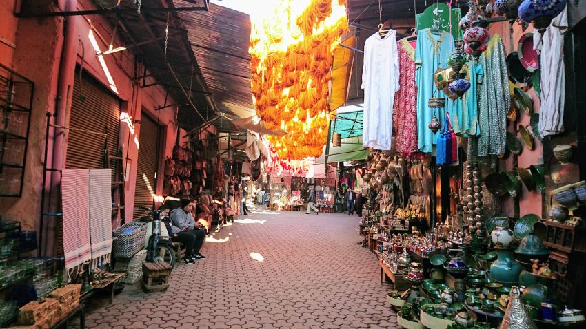
Marrakech is a renowned tourist destination in Morocco, known for its rich culture and history. The city evokes images of vibrant spices, bustling markets, and traditional architecture, including riads and ancient walled streets. Visitors can expect a vibrant and colorful experience, with a bustling energy that can be both captivating and overwhelming. The city boasts a wealth of history, culture and delicious Moroccan cuisine, with every turn revealing new surprises and experiences.
Marrakech also serves as a great starting point for exploring the surrounding areas. From deserts and waterfalls to Berber villages and rocky valleys, there are many options for day trips from the city. Marrakech, lies in the foothills of the High Atlas Mountains, it offers a unique gateway to the many natural, cultural and historical jewels that the region has to offer.
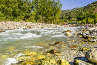
1. Ourika Valley Full-Day Trip from Marrakech
Ourika Valley in Marrakech
CC BY-SA 3.0 / Mustaphabelkasse
Located at the foot of the Atlas Mountains, the Ourika Valley is a picturesque destination known for its blooming apple and cherry trees in the spring. It’s a great place to escape the summer heat of Marrakech and enjoy nature with the sound of a flowing river and sightings of Barbary monkeys. The valley also offers beautiful hiking trails leading to a series of waterfalls, and is shaded by snow-covered mountains during the warmer months. Setti-Fatma, a small village at the base of the valley, is surrounded by almond trees and Berber villages made of mud-brick. This is a popular starting point for trekking to the Ourika Valley waterfalls, and it’s easy to find an English-speaking guide here to show visitors around for a reasonable fee.
How to reach Ourika Valley
Buses to Ourika: These depart from the Alsa bus stop in Marrakech. Alternatively, the bus L25 from the Bab Rab bus stop also takes visitors to the beginning of the valley where shared taxis are available for the 10 MAD per person trip to Setti-Fatma.
Shared taxi all the way: Another option is to take a shared taxi directly from Marrakech to Setti-Fatma. Shared taxis leave from a terminal located 3km outside the Bab Er Robb medina gate, in the south of the medina. The journey takes around 1 and a half hour. However, during low season, there might not be many passengers, so you may need to pay for the whole taxi. An alternative is to take a private taxi for the whole day, which can be arranged to bring you there and back, it should be around 500-600 MAD for a day, but it is better to agree on the final price in advance and pay at the end of the day.
Hire Car: Driving from Marrakech to Setti-Fatma is a convenient option, whether you have your own car or are renting one. The journey takes approximately one and a half hours. To get there, take the P2017 highway towards the southeast and continue on to Ourika. From there, take the P2030 highway, which will lead you directly to Setti-Fatma.
Day Tour: Joining a tour group is a popular choice for visiting the Ourika Valley from Marrakech. Many tour companies located near Jemaa el Fena square in Marrakech offer day trips to the valley. The prices for these tours typically range from 200 to 250 MAD per person and include transportation to and from the valley in a comfortable minivan as well as a visit to a Berber market. Keep in mind that some tour companies may have additional or hidden costs, such as for a local guide or food at restaurants. It’s often better to book these tours online. The description clearly states what is included in the price so you don’t get any extra hidden costs.
Here is a complete selection of hotel options in Marrakesh. Feel free to review each one and choose the stay that best suits your needs.
2. Splendid Imlil: Mount Toubkal Day Trip from Marrakech
Imlil Atlas Mountains Morocco
CC BY-SA 3.0 / Luc Viatour
Imlil, a small village located just an hour and a half from Marrakech, is home to the base of Mount Toubkal, the highest peak in the country. I had the opportunity to hike to the summit and it was an unforgettable experience! Although Mount Toubkal is often referred to as one of the easiest peaks above 4000 meters to climb, I found it to be more challenging than expected. Also Known as Jebel Toubkal in Moroccan Arabic, it summit stands at an altitude of 4167 meters. Despite the hike being hard, Imlil and Toubkal are excellent day trips from the bustling city of Marrakesh due to their proximity and year-round accessibility.
How to reach Imlil
Buses to Imlil: There are a few ways to reach Imlil from Marrakech. One option is to take a bus to the town of Asni, and then transfer to a shared taxi for the remainder of the journey to Imlil.
Shared taxi: Another way to get there is to take a shared taxi directly from Marrakech to Imlil. The shared taxi station is across the street from the Jemaa el-Fnaa bus stop, you can either take the whole taxi for 250 to 300 MAD or share with other passengers which is usually cheaper.
Hire Car: You can also drive to Imlil if you have your own car or rent one, but be careful as the road can be dangerous during winter time.
Day Tour: You can also go on a guided day tour from Marrakech to the Atlas Mountains and Imlil
Traveling to a country with a different currency? Avoid ATM transaction fees and pay in local currency with a Wise Card. Having used it for over 5 years, we've saved loads on fees!
3. One Day Excursion from Marrakech to Oukaimeden
Oukaimeden 1
CC BY-SA 4.0 / Zineb.B
Oukaimeden is a picturesque ski resort located approximately 80 kilometers from Marrakech, near Mount Toubkal. I was surprised to find such great snow for winter sports in a North African country. The resort offers fantastic ski slopes, as well as ski lift, accommodation, and rental options. The unique aspect of this resort is the ability to experience sub-zero temperatures on the slopes during the day and then return to the warm climate of Marrakech in the evening. A lift pass costs around 30 MAD for a half-day and 50 MAD for a full day, while ski equipment rental is around 70 to 80 MAD per day. Ski instruction is also available, with prices starting at 150 MAD for a half-day and 250 MAD for a full day.
How to reach Oukaimeden
Buses to Imlil: There are no bus services between Marrakech and Oukaimeden, as the road to reach there is winding and not wide enough for buses.
Shared taxi: One option is taking a shared taxi from the grand taxi station in Marrakech, which will cost around 300-400 MAD for a round trip.
Hire Car: Alternatively, if you have your own car or are renting one, you can drive from Marrakech to Oukaimeden via road P2017. The exit for Oukaimeden is near Aghbalou. It takes about 1 hour and a half to travel from Marrakech to Oukaimeden by car.
Day Tour: If you’re looking to escape the hustle and bustle of city life in Marrakech and enjoy skiing and snowboarding with a group of like-minded people, a full-day trip to Oukaimeden is an excellent choice. You’ll be picked up from your accommodation in Marrakesh at around 8 AM, and transported to the ski resort in a comfortable minibus. During the trip, your guide will provide local knowledge and make stops along the way. Once you arrive, your guide will arrange for any necessary equipment rental and then it’s time to hit the slopes! After a break for lunch, you’ll have the remainder of the afternoon to ski or snowboard before departing for Marrakech around 4 PM.
Keep in mind that Oukaimeden also offers summer activities, and that you can visit it as part of an Atlas Mountains & 4 Valleys Tour, including the Ourika Valley.
4. Desert Agafay and Atlas Mountains & Camel ride Day Trip
Agafay Desert
CC BY-SA 4.0 / Pierre.hamelin
The Agafay desert is a small desert located close to Marrakech. Unlike other deserts such as M’hamid and Merzouga, it doesn’t have the typical sand dunes, but it’s still a captivating place to visit. One way to explore the desert is by going on a tour from Marrakech, where you may have the chance to visit local villages by quad. Another interesting aspect of the Agafay desert is the man-made lake situated on its edge, which was constructed to provide electricity for the city of Marrakech. Visitors can swim on the lake’s beaches, rent jet skis or pedal boats, and explore the waters. The desert also offers many hiking, mountain biking and horseback riding trails in the hills above the lake.
How to reach Agafay Desert
Public Transport: It is not possible to reach Agafay desert by public transport from Marrakech. The best option to visit is by renting a car or by booking a day tour.
Hire Car: If you have your own car or rent one, you can head to Lalla Takerkoust reservoir which is situated in the middle of the Agafay desert. It takes about 47 minutes to get there from Marrakech city centre by following P2009 highway towards the southwest.
Day Tour: There are many tour operators that provide trips to Agafay desert from Marrakech, it’s important to check what is included in the tour and look out for any additional costs. Many companies have their tours online, that can be helpful to know the details of the tour before making the booking.
| Hours: The desert is always “open”, but camps and activity operators generally run from late morning through to the evening. | Price: There is no fee to enter the desert itself; individual camps and activities (quad biking, dinners, camel rides) charge their own prices.
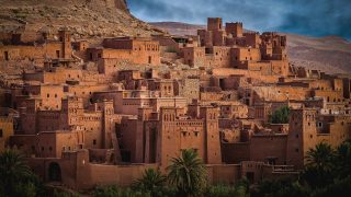
Ait Ben Haddou is an ancient mud-brick village located between the Sahara and Marrakech, known as a Ksar, or “Berber castle”. It is a UNESCO World Heritage Site and was used as a filming location for the TV series Game of Thrones. Reaching Ait Ben Haddou from Marrakech by public transport can take about 3 hours, and involves a bus ride to Ouarzazate and then a shared taxi from there to Ait Ben Haddou. The best way to do this is to take a CTM bus from the central bus station in Marrakech to Ouarzazate, which will cost around 80 MAD. From there, ask the driver to stop at the crossroads in Taborah, you’ll find taxi waiting for passenger there, and the cost will be around 10 MAD. It is worth noting that visiting both Ait Ben Haddou and Ouarzazate in the same day is a good idea as they are only 30 km apart.
How to reach Ait Ben Haddou
Public Transport: The most convenient way to reach Ait Ben Haddou by public transport is to take a CTM bus from Marrakech’s central bus station to Ouarzazate. The bus ticket will cost around 80 MAD and you may have to pay an additional 10 MAD for your luggage. Once you get on the bus, ask the driver to stop at the crossroads in Taborah, from there you will be 16 km away from Ait Ben Haddou. At this point, you can take a shared taxi from Taborah to Ait Ben Haddou, which should cost around 10 MAD if the taxi is shared with other passengers.
Hire Car: If you have your own car or if you are renting one for the day, it will be even easier to reach Ait Ben Haddou. Although you won’t have to waste time looking for a taxi or a bus, you’ll still have to drive a bit slower than usual. The road between Marrakech and Ait Ben Haddou is quite winding and there are a few treacherous curves along the way so I would advise driving there with caution. Ait Ben Haddou is located 184 km from Marrakech. Driving there should take about 3 hours and a half. To get there, simply follow highway N9 towards the south.
Day Tour: This is the most popular way for people to go a quick day trip to Ait Ben Haddou from Marrakech. There are many different travel companies based in Marrakech that offer tours to the mud village thus the prices for that trip vary greatly. The base price for that trip is around 300 MAD per person (around 30 euros). Some companies will also combine this tour with a visit to Ouarzazate, raising the prices around 700 MAD per person. You can expect a smooth ride in a very comfortable air-conditioned minibus and a few stops for refreshments along the way. They usually leave the city around 8:30 am and do a few stops along the way to the old fortified city. The pick-up will be directly at your hostel or hotel in Marrakech or at the Jemaa el Fna square in the morning. Most tours will provide you with an English or French-speaking driver. Some tours will include a local guide at Ait Ben Haddou in their price while others won’t. You should check this beforehand with your tour operator or in the tour description. The tours do not include lunch so you should either bring snacks or have money for the restaurants near the old city.
Although the paths are very easy to walk on, we suggest bringing a good pair of walking shoes or some sandals. Also, bring some sunscreen and don’t forget your camera!
Explore Marrakesh at your own pace with our self-guided walking tour! Follow our curated route to discover must-see sights and local secrets that makes Marrakesh one of the best places to visit in Morocco.
Visiting the Ouzoud waterfalls is an excellent day trip from Marrakech if you have access to a car. The journey from Marrakech is scenic, with many opportunities for taking beautiful photos along the way. The Ouzoud waterfalls are a series of tall and impressive waterfalls that cascade from high cliffs into a large pool of water. These falls are 110 meters high and are surrounded by lush vegetation. In the summertime, it is possible to take a refreshing swim in the water at the base of the falls, or take a boat ride closer to the falls for a small fee. The area around the falls is renowned for its olive trees and the presence of Barbary monkeys. It’s a place where you can enjoy nature, but it can become very crowded in spring and summer. The Ouzoud waterfalls are the second tallest waterfall in Africa and it’s very touristic place and one of the most popular and photograph natural sites in Morocco.
How to reach Ouzoud Waterfalls
Public Transport: One option for reaching the Ouzoud waterfalls from Marrakech by public transportation is to take a bus from Marrakech to Beni-Mellal, and then take a shared taxi from there to the waterfalls. This method is possible through CTM and Supratours, or local bus companies, but it can be time-consuming and more expensive than taking a shared taxi directly from Marrakech to Ouzoud. Please note that the bus ride from Marrakech to Beni-Mellal takes around 3h and 30 minutes, and the shared taxi from Beni-Mellal to Ouzoud takes around 1 hour, so the total travel time would be about 4h and 30 minutes.
Shared taxi: You can reach the Ouzoud waterfalls by taking a shared taxi from Bab Doukala in Marrakech. The shared taxi will take you to the village of Azilal, which is not far from the falls. The cost for a shared taxi from Bab Doukala to Azilal is around 50 MAD per person, if the taxi is full when you leave. However, some taxi drivers may not wait for the taxi to fill up before leaving, so the cost may be slightly higher. The cost for a taxi from Azilal to Ouzoud is cheaper, at around 25 MAD per person. If you prefer a faster journey, you can opt to pay for the whole taxi, which costs around 150 MAD.
Hire Car:If you decide to drive from Marrakech to the Ouzoud waterfalls, you can expect a scenic and picturesque journey. The drive will take you about two and a half hours along highway N8 and R208. Once you reach the village of Tanant, you will be close to the waterfalls and can park your car in one of the many parking areas nearby. However, it is important to note that there is a fee of between 10 and 20 MAD to park your car for the day, which can be paid directly to the parking attendant.
Day Tour: A tour to the Ouzoud waterfalls typically costs around 275 MAD per person, which includes transportation to and from the falls via a comfortable minivan. Additional expenses such as the cost of a local guide or food near the cascades are not included. By booking a tour, you will avoid the inconvenience of searching for public transport to the falls, and enjoy a comfortable, air-conditioned minibus ride with refreshment stops along the way.
Explore Marrakesh at your own pace with our self-guided walking tour! Follow our curated route to discover must-see sights and local secrets that makes Marrakesh one of the best places to visit in Morocco.
7. Marrakech: Camel Ride in Palm Groves (Palmeraie)
La Palmeraie de Marrakech
CC BY-SA 2.0 / Viault
The Palm Grove, or La Palmeraie, is a stunning location located just under an hour from Marrakech city. An ideal destination for a day trip, it’s a perfect escape from the hustle and bustle of the city. Spanning over 13,000 hectares and boasting about 150,000 palm trees, it offers a perfect spot for camels to rest in the shade and escape the desert heat. The grove features an ancient irrigation system that has been in use for centuries and visitors can expect a unique cultural experience, as there are many date sellers and growers working in the oasis.
How to reach La Palmeraie
Public Transport: Accessing the Palmeraie from the city center via shared taxi or public bus can be difficult, however a great alternative is to take the Hop on Hop off Marrakesh City Tour Bus. This bus features an open upper deck, providing comfortable panoramic views of the city. Additionally, the bus offers a special Palm Grove Tour route that takes you to the northern part of the city and the Marrakech Palm Grove. Along the way, you’ll have the opportunity to participate in activities such as camel and quad rides. The route includes 13 stops and lasts approximately one hour.
Day Tour: I highly recommend this guided tour to the Palm Grove of Marrakech. It features a scenic camel ride through the palm trees of the Palmeraie, usually followed by an exhilarating off-road experience on quad bikes.
Essaouira is a charming coastal town that offers a more relaxed and peaceful atmosphere compared to the bustling city of Marrakech. The town showcases an interesting blend of Moroccan culture and Portuguese architecture. Essaouira is a popular destination for young surfers and backpackers who come to the town for the great waves and nearby beaches, but also for the picturesque streets lined with beautiful handicrafts by local artisans. The town is known for its markets selling wooden crafts. It also boasts its own fortified old medina, delicious local cuisine, and a unique, fun and hip energy that sets it apart from other Moroccan cities. The town is conveniently located near Marrakech and is easily accessible from nearby coastal cities such as Casablanca and Rabat.
How to reach Essaouira
Public Transport: The small town is located two hours and a half west of Marrakech and is easily reached by bus or by shared taxi. Getting a bus to Essaouira from Marrakech is relatively easy. You can find a Supratour or a CTM bus to Essaouira near the main Marrakesh train station. The journey with bus from Marrakech to Essaouira takes about 3 hours with a twenty-minute break somewhere along the way. This is the cheapest option as a bus ticket costs around 80 MAD per person.
Shared taxi: The fastest way to get from Marrakesh to Essaouira – if you don’t have a car – is by shared taxi. The price per person in a shared taxi should be between 450 and 1000 MAD.
Hire Car: If you travel by car, the fastest way to get to Essaouira from Marrakech is by following the highways A7, N8 and R207. From Marrakech, you will have to drive north-west on the A7 until it merges with highway N8 and R207. Follow the highway R207 west until you reach Essaouira. The distance between Marrakech and Essaouira is 191 km and driving there will take about 2h40 minutes.
Day Tour: You can also prefer to go on a guided day excursion from Marrakech to Essaouira. The advantages of such tours is that you’ll travel by private transport and learn about the rich cultural mixture that has influenced the city’s architecture while walking in the medina of Essaouira with a guide. You’ll have time to relax on the beach and some tours also offer a visit to local women’s cooperatives that make argan oil.
Let’s face it, Casablanca is a very busy city and probably nowhere as quiet and romantic as Essaouira. If you would have just a few weeks to spend in Morocco, it’s not necessarily a city I would recommend.
If you’re in Morocco for a while, however, it could definitely be worth spending some time in this city and then heading back to Marrakech or continuing north towards Rabat or Tangier. Casablanca is a city that has been featured in many movies and it has a fascinating history. It’s a great place to see how modern Morocco mixes with centuries of traditions and architecture.
How to reach Casablanca
Public Transport: Because Casablanca is a bit farther from Marrakech than the other destinations mentioned in this guide, I would only recommend taking the most comfortable buses in Morocco to get there. The most comfortable buses in the country are owned and operated by two companies; CTM and Supratours. The CTM bus stop and the Supratours station are located both very close to each other in an area called Gueliz in the suburbs of Marrakech. It will require a taxi to get there from Jemaa el Fenaa. These buses are much more comfortable than the ones owned by less reputable companies but they also tend to be a bit more expensive. The trains in Morocco are very comfortable and they are the best way to see the Moroccan landscapes while moving from city to city. There is a train that goes from Marrakech towards Casablanca every two hours. It takes about two hours and a half to get there and the ticket costs around 110 MAD.
Shared taxi: There are different taxis going from Marrakech to Casablanca. Shared ones and private ones. The shared taxis are usually old Mercedez Benz in which up to six people are squeezed together.
They are not the most comfortable option but they are definitely cheap. The price per person in a shared taxi should be around 110 MAD. Because this is quite a long distance, I wouldn’t advise taking a shared taxi if you’re traveling with someone else or a group of people and you have luggage. Paying for a private taxi for your group would be a much better option. The price for a private taxi from Marrakesh to Casablanca is around 1000 MAD.
Hire Car: If you have your own car, the fastest way to get to Casablanca from Marrakech is by following the highways A7 and N11. From Marrakech, you will have to drive north for almost three hours before reaching the coastal city.
Day Tour: It could also be nice to go on a guided day tour from Marrakech to Casablanca. You’ll travel comfortably by private transport and visit Casablanca’s main attractions such as the Mosque of Hassan II, Rick’s Cafe, and the Art Deco hotels while learning more about the city’s background.
This website uses affiliate links which earn a small commission at no additional cost to you.
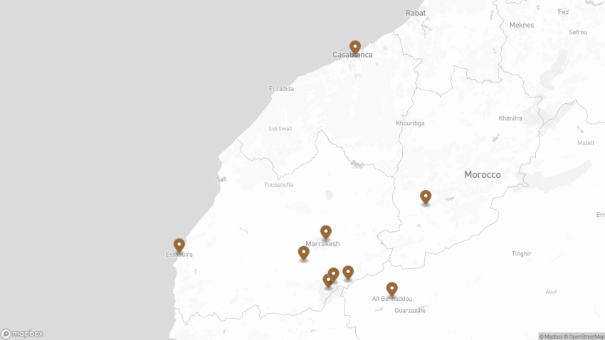
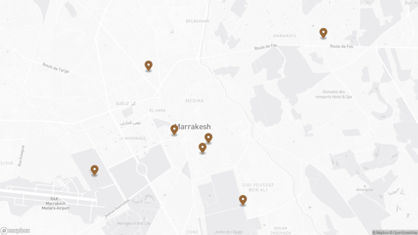
Walking Tour Map
Preview map of the Best Trips from Marrakesh, Morocco: Day Trips & Weekend Getaways route in Marrakesh, showing 9 stops. Use the interactive map to zoom and tap markers.
Guide to the Valleys of the High Atlas Mountains 2026: Routes, Villages & Tips
Ourika Valley in Marrakech
CC BY-SA 3.0 / Mustaphabelkasse
This website uses affiliate links which earn a small commission at no additional cost to you.
The three valleys in the Atlas mountains are an easy day trip from Marrakech. What are they and why should you visit them?
The Atlas Mountains separate the Sahara Desert from the Mediterranean Sea and the Atlantic Ocean; the name “Atlantic” is derived from the mountain range. It stretches around 2,500 km (1,600 mi) through Morocco, Algeria and Tunisia. The range's highest peak is Toubkal, which is in central Morocco, with an elevation of 4,167 metres (13,671 ft). The Atlas mountains are primarily inhabited by Berber populations. It is known by local Berbers as 'Idraren Draren' (Mountains of Mountains).
Ourika Valley
Ourika valley is known for its stunning gorges and terraced fields along the river, is a popular destination for day trips due to its beautiful scenery, refreshing air, and proximity to Marrakech. The popularity of the area can be seen in the numerous restaurants and souvenir stalls along the route, as well as plans for a property development funded by Dubai.
The valley begins at the village of Souk Tnine de l’Ourika (Akhlij), which hosts a market on Mondays and attracts tourists like the nearby Asni Village market on Saturdays.
During the warmer months, it is possible to hike to the peak of Jebel Oukaïmeden (3,263 meters/10,705 feet) from the village. The moderate 650-meter (2,133-foot) ascent offers beautiful views, particularly at sunset. This area is a good choice for a peaceful and refreshing break, as it is about 10 degrees cooler here in the summer than in Marrakech. Birdwatchers may want to look for the elusive crimson-winged finch that lives in this area.
At the end of the tarred road in the Ourika Valley is the village of Setti Fatma, which was rebuilt after devastating floods in 1995 and now has a mix of modern concrete housing blocks and traditional homes. Despite the development, the village’s setting among grassy terraces, walnut groves, and mountain peaks is still beautiful and makes it a good starting point for treks to Jebel Toubkal and the surrounding area. A 30-minute scramble up the rocky foothills above Setti Fatma leads to a series of waterfalls (called cascades by the locals) with cafes nearby. The lower falls are easy to access, but the higher ones may be more challenging. Guides are available to take visitors to the higher falls.
Oukaimden Valley
Oukaimden valley, and taking a secluded mountain road route standing at 1800 meters above sea level, you will pass through traditional Berber villages built from adobe and stones, and discover the authentic life of Berber people. It is a ski base during the winter and a beautiful starting point for trekking during the warmer months. If a proposed property development is approved, the village will be transformed into a golf course and ski resort with a water park, exclusive shops, and artificial beachfront. The chairlift on Jebel Oukaïmeden, previously the highest in the world at an elevation of 3,273 meters (10,739 feet), may also be renovated.
Ansi Valley
Asni valley is famous by its fruit trees (Apples, walnut, almonds, peaches…), this is where you can enjoy the sight of the snowy summits of the High Atlas Mountains. Tourists visiting Imlil may encounter aggressive touts, but the weekly Saturday market, or souk, is worth checking out. The market offers a variety of local produce and livestock, as well as services such as dentistry and barbering. Visitors may also see a large group of mules with brightly colored saddles. This is a good opportunity to purchase supplies for trekking, although it is advisable to arrive early to avoid the crowds of day-tripping tourists. Above the village are the lower, forested slopes of the Kik Plateau, which is a beautiful place to go for a walk, especially in spring when it is covered in alpine flowers.
Azzaden Valley
Azzaden Valley, just south of Imlil, is often touted as the quieter alternative to Imlil. It is possible to walk from Imlil to Azzaden Valley (about six hours). You can also start the hike to the summit of Jbel Toubkal from here.
Ouirgane Valley
Ouirgane Valley in the foothills of the High Atlas MountainsMarigha. The Ouirgane valley is at its most beautiful in spring. At this time, flowers line the valley floor and the crops are a bright green. It is in the middle of the Toubkal National Park. It contains the villages of Ouirgane, Marigha, Torord and Tinmel. Salt is mined from huge wells of brine in the valley. The brine is left for the water to evaporate on salt pans before it is gathered and carried on donkeys to the neighbouring villages to be sold.
The Oued Nfis river which runs through the valley has been dammed to form a reservoir.
The valley has the Tinmal Mosque or Great Mosque of Tinmal, a 12th-century mosque located in the village of Tinmel. Although no longer operating as a mosque today, its remains are preserved as a historic site.
The Gardens of Marrakesh 2026: A Guide to the City’s Green Oases
Koutoubia Gardens
This website uses affiliate links which earn a small commission at no additional cost to you.
If you're planning on spending some time in Marrakesh and want to avoid feeling overwhelmed by the hustle and bustle of the city, it's a good idea to take breaks in the many beautiful gardens and parks scattered throughout the city. These green spaces not only offer a chance to relax and get back to nature, but they're also great destinations in their own right. Many of the gardens are free or only cost a small fee of 10 dirhams, making it easy to take a quick break and unwind. If you find yourself feeling overwhelmed by the crowds and chaos of the medina, make sure to visit one of these peaceful gardens to rejuvenate your spirits.
1. Jardin Majorelle
Le jardin des majorelle
CC BY-SA 2.0 / Viault
Jardin Majorelle is a must-visit garden in Marrakesh and a popular spot for tourists to take selfies. The 12-acre botanical garden is centered around a stunning riad with Moroccan architectural elements, and features vibrant blue and yellow colors. Visitors can wander through the shady lanes surrounded by exotic plants and relax by tranquil streams with floating lilies and lotus flowers. The garden was named after French artist Jacques Majorelle, who designed the building in the 1920s and 1930s. It also houses a small archaeological museum with interesting displays on Islamic art and Berber culture. To enjoy the garden in peace and quiet, it’s recommended to visit early in the morning before the crowds arrive or later in the afternoon after they have left.
The Bahia Palace is a must-see destination for anyone interested in traditional Marrakeshi palaces and gardens. Located inside the old medina of Marrakesh, the palace boasts beautiful Andalusian-style architecture and intricate zelij mosaic and woodwork. The exact dates of construction are unknown, but it is believed to have been in use as early as 1859 and completed by 1900. The palace was built in two stages by Si Moussa and his son, resulting in an irregular and disjointed layout that adds to the sense of adventure and discovery as you explore its different sections. The materials used in the palace’s construction, including zelij, ceramic, and wood, were sourced from all over North Africa. Consider taking a guided tour to learn more about the history and geography of Morocco through the palace’s architecture. It’s best to visit the Bahia Palace early in the morning to avoid the crowds.
Traveling to a country with a different currency? Avoid ATM transaction fees and pay in local currency with a Wise Card. Having used it for over 5 years, we've saved loads on fees!
El Badi Palace is a ruined palace located in the Mellah district of Marrakesh, a short walk from the Bahia Palace. The palace, which was commissioned by Arab Saadian sultan Ahmad-al-Mansur and completed in 1593, is currently being renovated and restored. Despite its state of disrepair, many visitors prefer El Badi to Bahia Palace due to its unique charm. The palace complex took 25 years to build and was constructed using the most expensive materials available at the time, including gold and onyx. Visitors can explore the sunken gardens and pavilions and marvel at the superb examples of Saadian architecture on display. El Badi Palace can be easily combined with a visit to Bahia Palace for a full day of exploring Marrakesh’s rich history and culture.
The Palmeraie is a vast palm grove on the northern outskirts of Marrakesh, covering an area of 54 square miles and stretching for 5 miles in length. At one time, it was one of the largest palm groves in North Africa. While there are hotels and restaurants located within the oasis, such as the Palmeraie Golf Palace, you can also get a feel for the area by simply driving through it. Camels and guides can often be found along the roadside, waiting to take tourists on camel rides through the oasis. There is a legend that the Palmeraie was created from the date seeds thrown on the ground by Arab warriors, but it was actually developed during the Almoravid period using a system of underground irrigation channels known as qanats. Today, the irrigation system has run dry, but you can still see traces of it if you walk through the grove.
The Menara garden is located west of Marrakesh, near the gates to the Atlas mountains. It is often referred to as the “little sister” of the Agdal garden. Both gardens were established by the Almohad dynasty and feature large basins that were used to irrigate the surrounding groves and orchards using an advanced system of underground channels. The Menara garden gets its name from the small green pyramid-roofed pavilion (menzeh) located within it, which translates to “light house.” However, the name does not refer to any actual lighthouse function, but rather to the pavilion’s religious significance. The Menara garden has a similar feel to the Agdal and is a peaceful place to relax and enjoy nature.
Explore Marrakesh at your own pace with our self-guided walking tour! Follow our curated route to discover must-see sights and local secrets that makes Marrakesh one of the best places to visit in Morocco.
6. Koutoubia Gardens and Cyber Park
Koutoubia Mosque in Marrakesch
CC BY-SA 4.0 / Max221B
If you’re looking for a quick and easy way to escape the hustle and bustle of the medina in Marrakesh, there are several parks and gardens located near the Koutoubia Mosque that are worth checking out. Simply cross the road from Djemma El Fna and take a stroll through the parks and fountains behind the mosque. The Cyber Park is also just a short 2-minute walk from the Koutoubia and offers a slightly more modern atmosphere. It’s a popular spot for locals to relax and is a great place to sit under a palm tree and read a book or watch the world go by. These parks are convenient and offer a welcome respite from the busy city.
Location: Parc Lalla Hasna, Marrakesh, Morocco | Hours: Generally open at all daylight hours, though the most comfortable and lively times are from early morning until late evening. | Price: Free - this is a public park open to everyone.
Explore Marrakesh at your own pace with our self-guided walking tour! Follow our curated route to discover must-see sights and local secrets that makes Marrakesh one of the best places to visit in Morocco.
7. Agdal Gardens
Agdal Gardens, Marrakech
CC BY-SA 2.0 / mwanasimba
The Agdal Gardens are perhaps the most important garden in Marrakesh and were built by the Almohad dynasty in the 12th century. The gardens were originally created as an orchard and cover an area of over 400 hectares. The name “Agdal” derives from an Amazigh word meaning “walled meadow,” which reflects the lines of groves that make up the vast expanse of the garden. These groves include orange, lemon, fig, apricot, and pomegranate trees, as well as rows of olive groves. While some visitors may find the Agdal gardens a bit underwhelming, as there is no specific trail to follow or museum on site, the panoramic view over the water and groves is breathtaking. The true spectacle of the Agdal gardens lies in their sophisticated irrigation system, which includes a network of underground channels that bring water from the Atlas mountains to a vast water basin that feeds the groves and orchards all year round.
This website uses affiliate links which earn a small commission at no additional cost to you.
Walking Tour Map
Preview map of the The Gardens of Marrakesh: A Guide to the City’s Green Oases route in Marrakesh, showing 7 stops. Use the interactive map to zoom and tap markers.
Self-Guided Walking Tour of Marrakesh's Medina, Morocco (2026)
Djemaa el FnaMarrakesh
CC BY-SA 3.0 / Boris Macek
This website uses affiliate links which earn a small commission at no additional cost to you.
Marrakesh, one of Morocco's four Imperial Cities, was founded in the 11th century and is known for its abundance of mosques, palaces, and museums. It is the most popular tourist destination in the country. The medina, the historic walled city, is the centre of Marrakesh and is characterized by its narrow, cobblestone streets and vibrant souks. The streets are primarily used by pedestrians and donkey carts, and have remained largely unchanged for centuries.
By Air:Marrakesh Menara Airport (RAK) is the main international gateway, located just 15 minutes by taxi from the city centre. For the best deals and a seamless booking experience, check out these flights to Marrakesh on Booking.com.
By Train:Marrakesh is the final stop on Morocco's rail network from Casablanca and Rabat. The train station is about a 10-minute drive from the Medina. Train schedules and bookings can be found on Omio.
By Car:Marrakesh is well connected to major cities like Casablanca and Agadir via highways. If driving, be aware that parking inside the Medina is limited-consider using outer car parks and walking in.
Where to Stay in Marrakesh
Staying near the Medina is ideal for walkers. Riad Kniza offers classic Moroccan elegance and easy access to the souks. For a boutique stay, El Fenn blends contemporary style with traditional design. Budget travellers might enjoy Equity Point Marrakech, a sociable hostel close to major landmarks.
A Brief History of Marrakesh
Founded in the 11th century by the Almoravid dynasty, the Medina of Marrakesh quickly became a powerful political and cultural hub in North Africa. The city's distinctive red walls, built from local clay, gave rise to its nickname, “The Red City.” Under successive dynasties-the Almohads, Saadians, and Alaouites-the Medina flourished with the construction of mosques, palaces, and sprawling gardens.
The Medina's layout, shaped by centuries of trade and craftsmanship, reflects a way of life rooted in community and commerce. Narrow alleys and bustling souks were designed for both protection and connection, linking residential quarters with religious, social, and economic centres. Today, the Marrakesh Medina is a UNESCO World Heritage Site, preserving its role as a living example of Islamic urban planning and Moroccan cultural identity.
Guided or Self-Guided Tour of Marrakesh?
Marrakesh’s medina is an atmospheric maze, and while it’s thrilling to explore independently, a local guide adds context and direction. The Marrakech: Bahia Palace, Saadian Tombs, Souk and Medina Tour is a top-rated experience that covers major highlights in a few hours. Led by an expert guide, you’ll delve into hidden corners of the souks, uncover the significance of ornate monuments, and gain a deeper understanding of Marrakesh’s layered history.
Your Walking Tour of Marrakesh
This blog highlights Marrakesh’s essential stops, but give yourself time to get lost in the medina’s rhythm-sometimes the best sights are the ones you stumble upon.
1. Jemaa el-Fnaa square
Djemaa el FnaMarrakesh
CC BY-SA 3.0 / Boris Macek
The Jemaa el-Fnaa square ishe bustling hub of activity in Marrakech. it is situated in Medina, its wide, open space contrasts with the narrow, maze-like streets around. You can find so many various food and other goods stalls here that it’s overwhelming. By day, snake charmers and henna ladies dot the square and scout for customers. When the sun goes down, the smoke from numerous cauldrons with soup and grill with meat rises and floats above Jemaa el-Fnaa.
Location: Jemaa el-Fnaa, Rue des Banques, Marrakesh, Morocco | Hours: Effectively 24/7, with the liveliest period from late afternoon into late evening. | Price: Free - Jemaa el-Fnaa is a public square open to everyone.
Marrakesh’s Medina is the equivalent to “Old Town” in European cities. It’s basically a maze of winding, tiny streets filled with shops and old style apartments. If you don’t mind the ubiquitous chaos, mess and noise – it’s a good place to stay – you will be close to most of the attractions around. Remember that no cars are allowed in Medina – taxis stop outside the main gate. But beware of motorcycles. They can appear out of nowhere and the drivers don’t seem to care much about the passer-by. Here, in the souks (street stalls and markets), you can buy many herbs, spices and souvenirs. You must know how to bargain though, as the sellers can be pushy and intimidating.
Souk Semmarine
Located next to the city’s main square, Jemaa al-Fnaa, the visually appealing Souk Semmarine is the largest market in the whole of Morocco, where traders have been selling goods for the past 1,000 years. If you’re after colorful accessories such as authentic bags, shoes, or clothes, then this is the right place to wander around. The henna artists, hawkers and other locals trying to take advantage of tourists can get somewhat overwhelming, but that is all part of the experience.
Rahba Kedima Square
This is one of the best market squares (though really more of a triangle) in the Medina district and is friendlier and more spacious than the souks, with ready-to-haggle vendors setting up their wares on the ground or on trestle tables. More traditional and more street-market-style than other, busier spots, it’s also a great area to see basket weavers in action.
Souk Zrabia (Carpet Market)
Souk Zrabia is found on the left side of the Rahba Kedima. Here you will find handmade rugs, carpets and kilims that are brightly painted and at reasonable price. There are also embroidered sheep wool hats found on this market.
Souk des Teinturiers (Dyer’s market)
The Souk des Teinturiers is probably one of the most picturesque in Marrakech. For many, it is the favourite Instagram spot in the city. The souk is maintained despite the industrial dyes because nowadays it is primarily a tourist attraction. Here you can see workshops with steam emanating from the tanks and big skeins of wool hanging to dry.
Location: Rahba Lakdima, Marrakech 40000, Morocco | Hours: Around 9am to 9pm, the best time to visit is in the cool of the morning, or in the evening | Price: Free - the souks are public market streets.
Traveling to a country with a different currency? Avoid ATM transaction fees and pay in local currency with a Wise Card. Having used it for over 5 years, we've saved loads on fees!
Le Jardin Secret was in the 19th century one of the largest riads in the medina of Marrakech and belonged to the Chancellor of Sultan Moulay ‘Abd-al-Hāfiz, who was the last sultan of Morocco before the French protectorate.
The riad includes two courtyards. The larger has been restored as an Islamic paradise garden, reflecting the pure geometry and Koranic symbolism of its progenitors. The smaller garden shows another view of paradise, as described in the Old Testament book of genesis, where “out of the ground the Lord God caused to grow every tree that is pleasing to the sight and good for food.”
The Dar el Bacha Museum, located near the entrance to the medina of Marrakech, is considered one of the most beautiful places in the Red City. The Dar el Bacha Museum was once the home of Thami El Glaoui, the pacha of Marrakech. It underwent a restoration project led by the National Museum Foundation, and reopened as a museum in December 2017.
The Koubba is a 12th-century building in Morocco that is the only surviving Almoravid structure in the country. It was renovated in the 16th century and was later covered by an outbuilding attached to the Ben Youssef Mosque. The Koubba was discovered during excavation work in 1948 and can now be accessed by a flight of stairs. It is known for its ornate dome, decorative windows, and intricate interior motifs, including acanthus leaves, palms, pine cones, and calligraphy from the Quran. The Koubba was used for ritual washing before prayer and has an inscription in ancient cursive Maghrebi script that reads, “I was created for science and prayer.”
Location: Almoravid Koubba, Derb Souk Cheria, Marrakesh, Morocco | Hours: Typically open daily during standard museum hours, roughly from late morning to late afternoon; check locally for current times. | Price: Expect a small fee of just a few euros, often combined with or similar to the Museum of Marrakech ticket prices.
Housed in the 19th century Dar Menebhi Palace, which was beautifully restored in 1997 by the Omar Benjelloun Foundation, the Musée de Marrakech is worth visiting to see one of the best examples of Arab/Spanish architecture. With its calming fountains, seating areas and detailed tile work, the central courtyard, which functions as the museum’s atrium, was once open to the sky but now has been covered with glass. Its show-stopper is, undoubtedly, the huge hanging chandelier made of metal shards, each one delicately decorated with inscriptions and geometric symbols. The side rooms around the courtyard have lovely painted wooden ceilings and house several pieces of interest, such as historical books and manuscripts, jewel-encrusted daggers and swords, clothes, coins, carpets and pottery from Arab, Berber and Jewish civilizations. The museum also holds temporary exhibitions on modern Moroccan art, but sadly, the explanations of each item, along with those in the permanent exhibition, are all in Arabic/French.
Explore Marrakesh at your own pace with our self-guided walking tour! Follow our curated route to discover must-see sights and local secrets that makes Marrakesh one of the best places to visit in Morocco.
7. Ben Youssef Madrasa
Ben Youssef Madrasa, Marrakesh, Morocco
CC BY-SA 2.0 / yeowatzup
The Ben Youssef Madrasa was the largest and most important Islamic school in Marrakech and Morocco. Built almost 500 years ago, the Ben Youssef Madrasa in Marrakech feels like it has changed very little in that time.
You’ll find the Ali Ben Youssef Madrasa in the Medina district of Marrakech and you shouldn’t miss a trip to visit this important building, renovated and opened to the public in 1982. Founded in the 14th century and rebuilt in the 16th, during the Saadian Dynasty, the Madrasa was part of the complex of the nearby Almoravid mosque which was founded by Ali Ben Youssef during his reign between 1106-42, to which it was once attached.
This website uses affiliate links which earn a small commission at no additional cost to you.
Walking Tour Map
Preview map of the Self-Guided Walking Tour of Marrakesh’s Medina, Morocco route in Marrakesh, showing 7 stops. Use the interactive map to zoom and tap markers.
Self-Guided Walking Tour of Marrakesh, Morocco (2026)
Koutoubia Mosque in Marrakesch
CC BY-SA 4.0 / Max221B
This website uses affiliate links which earn a small commission at no additional cost to you.
Marrakesh, the vibrant heart of Morocco, is a city where ancient traditions and bustling modern life coexist in a kaleidoscope of colors, scents, and sounds. From the maze-like alleys of the Medina to the grand palaces and serene gardens, every corner of Marrakesh tells a story. A walking tour allows visitors to immerse themselves fully in the city's energy, exploring its souks, historic sites, and lively public squares at a pace that reveals its rich cultural layers.
The city is renowned for its iconic landmarks, including the bustling Jemaa el-Fnaa square, where snake charmers, storytellers, and food stalls create a sensory spectacle, and the Koutoubia Mosque, whose striking minaret is visible across the city. Wandering the narrow streets, you encounter traditional riads, artisan workshops, and centuries-old markets, each offering a glimpse into the city's history and daily life. The contrasts between the bustling Medina and the tranquil gardens or palaces highlight the diverse experiences that Marrakesh offers on foot.
A walking tour also provides an intimate connection with Marrakesh's art, architecture, and culture. From the intricate tilework of the Bahia Palace to the vibrant displays of spices, textiles, and pottery in the souks, visitors can experience the city's aesthetic richness firsthand. By exploring on foot, you gain a deeper appreciation of the city's layered history, the rhythms of everyday life, and the warmth of its people, making a walking tour an essential way to experience Marrakesh.
By Air:Marrakesh Menara Airport (RAK) is the main international gateway, located just 15 minutes by taxi from the city centre. For the best deals and a seamless booking experience, check out these flights to Marrakesh on Booking.com.
By Train:Marrakesh is the final stop on Morocco's rail network from Casablanca and Rabat. The train station is about a 10-minute drive from the Medina. Train schedules and bookings can be found on Omio.
By Car:Marrakesh is well connected to major cities like Casablanca and Agadir via highways. If driving, be aware that parking inside the Medina is limited-consider using outer car parks and walking in.
Where to Stay in Marrakesh
To make the most of visiting Marrakesh and this walking tour, it is best to stay overnight in the centre, particularly in or near the Medina, where many of the city's iconic landmarks, souks, and squares are within easy walking distance. In the heart of the Medina, Riad Kniza offers an authentic Moroccan experience with luxury and traditional décor. Another popular choice is La Maison Arabe, known for its refined riad-style accommodations and excellent location close to Jemaa el-Fnaa. For a more boutique experience, Riad Be Marrakech provides a quiet retreat within the bustling Medina.
In the slightly more modern area of Gueliz, Le Palais Rhoul & Spa combines contemporary comfort with traditional Moroccan charm, while Kenzi Club Agdal Medina offers spacious rooms and amenities ideal for families or those wanting resort-style facilities near the city centre. Four Seasons Resort Marrakech is a luxurious option, blending tranquil gardens with easy access to the main attractions of both the Medina and the newer districts.
A Brief History of Marrakesh
Marrakesh, founded in 1070 by the Almoravid dynasty, quickly became one of Morocco's most important cities, serving as a political, cultural, and economic hub. The city's iconic Jemaa el-Fnaa square has been the beating heart of Marrakesh for centuries, hosting markets, storytellers, and performers, and remains a symbol of the city's vibrant public life. Over time, Marrakesh expanded with impressive architectural projects, including the Koutoubia Mosque, constructed in the 12th century under Almohad rule, whose soaring minaret is a defining landmark visible from across the city. Surrounding the mosque, the Koutoubia Gardens (also known as Lalla Hassna Park) provide a green oasis amidst the urban bustle.
During the Saadian period in the 16th century, Marrakesh saw a flourish of art and architecture. The Saadian Tombs reflect the dynasty's craftsmanship and ornate design, while the El Badi Palace, commissioned by Sultan Ahmed al-Mansur, was built to showcase the city's wealth and power. The later Bahia Palace, constructed in the late 19th century by Grand Vizier Si Moussa and his son, demonstrates intricate Moroccan artistry with expansive courtyards, lush gardens, and elaborate tilework. Religious life also shaped the city, with landmarks like the Kasbah Mosque serving as spiritual centers for centuries.
Marrakesh’s city walls, including the famous Bab Agnaou gate, stand as enduring reminders of its strategic importance and historical fortifications. The Musee Dar Si Said, housed in a former palace, preserves Moroccan art and crafts, offering insights into the city’s cultural richness. From its bustling squares to grand palaces and historic mosques, Marrakesh’s layered history-from Almoravid founding through Saadian and later Moroccan dynasties-can be explored on foot, revealing a city where past and present intertwine seamlessly.
Guided or Self-Guided Tour of Marrakesh?
Marrakesh’s medina is an atmospheric maze, and while it’s thrilling to explore independently, a local guide adds context and direction. The Marrakech: Bahia Palace, Saadian Tombs, Souk and Medina Tour is a top-rated experience that covers major highlights in a few hours. Led by an expert guide, you’ll delve into hidden corners of the souks, uncover the significance of ornate monuments, and gain a deeper understanding of Marrakesh’s layered history.
Your Walking Tour of Marrakesh
This blog highlights Marrakesh’s essential stops, but give yourself time to get lost in the medina’s rhythm-sometimes the best sights are the ones you stumble upon.
1. Jemaa el-Fnaa
Djemaa el FnaMarrakesh
CC BY-SA 3.0 / Boris Macek
Jemaa el-Fnaa is a great place to start our tour. Look for the Minaret de la Koutoubia in the west. You will use this to orient yourself if you get lost!
The Jemaa el-Fnaa is Marrakech’s main square and the most important part of the medina. Jemaa el-Fna is the city’s top attraction and can be visited at all hours of the day. At this fascinating spot, you’ll find snake charmers, the magical souk, monkeys and henna artists. The best view of Jemaa el Fna is from one of the roof terraces framing the edge of the square. Look for Le Grand Balcon du Café Glace – it is perfectly positioned to witness the full scale of the activity on the square below.
Location: Jemaa el-Fnaa, Rue des Banques, Marrakesh, Morocco | Hours: Effectively 24/7, with the liveliest period from late afternoon into late evening. | Price: Free - Jemaa el-Fnaa is a public square open to everyone.
Leave the square by the eastern road (away from the Minaret de la Koutoubia), turn right onto Rue Riad Zitoun el Jdid by the restaurant Marrakchi. About halfway down this street (by the Herboristerie La Musée – avoid this place), you nee to turn left – you may need to ask for directions or find the sign posts for the Musee Dar Si Said.
The Musée Dar Si Saïd, also known as the Museum of Moroccan Art, is housed in a stunning palace in Marrakech. The palace was built in the mid 19th century for Si Saïd ibn Moussa, the Minister of War, and boasts a beautiful courtyard with flowers, cypress trees, a gazebo, and a fountain. The exhibition rooms surrounding the courtyard are adorned with intricately carved doors, intricate stucco work, and mosaics, as well as a domed reception room and harem quarters.
The museum’s collection is highly regarded and includes jewellery from various regions in Morocco, carpets, oil lamps, pottery, and leather work. A standout piece in the collection is a 10th-century Spanish marble basin, which was brought to Marrakech by Sultan Ali ben Youssef in 1120 and initially placed in a mosque despite its depiction of an eagle and griffons, which goes against Islamic law. The basin was later moved to the Ben Youssef Madrasa and eventually donated to the museum after the college’s restoration.
Traveling to a country with a different currency? Avoid ATM transaction fees and pay in local currency with a Wise Card. Having used it for over 5 years, we've saved loads on fees!
3. Bahia Palace
Bahia Palace large court
CC BY-SA 4.0 / Val Traveler
Head south from the Musée Dar Si Saïd, turn right onto Rue de la Bahia. You should pass the Tiskiwin Museum on your right. You shoudl turn left onto Rue Riad Zitoun el Jdid, at the end of which is theentrance to the Bahia Palace.
The Bahia Palace, also known as the “Palace of the Brilliant/Beautiful,” is a stunning late 19th century palace that spans 8 hectares, including a garden. Located close to the royal El Badi Palace and about 900 meters southeast of Jemaa el-Fnaa, the Bahia Palace is an oasis of calm in the midst of the bustling medina souk and offers a respite from the noise of traffic. The complex features 150 rooms, patios, courtyards, fountains, and gardens, and is adorned with intricate tile work, mosaics, coloured glass, carvings, and elaborate ceilings.
Originally built for Si Moussa, the Grand Vizier of Sultan Hassan I, the Bahia Palace was the largest and most luxurious palace in Morocco at the time. During the French Protectorate, it was the residence of General Hubert Lyautey, who added electricity, fireplaces, and heating. Although the rooms are not furnished with period furniture, the tiled walls and ceilings more than make up for it. Visitors can explore the palace in about 30 minutes, but it is also enjoyable to spend more time taking in all of the details of the palace.
From the Badia Palace head west and you will soon find yourself in the Place des Ferblantiers,a palm-lined square in the Mellah with artisans selling handcrafted tin lamps & housewares. People will probably approach you to tell you that the Badi palace is closed for lunch, but that is not the case. Don’t listen to them, the palace is open non-stop all day!Leave the square to the south through the archway. Turn right onto Rue de Berrima.
The El Badi Palace, also known as the “Incomparable Palace,” was once a grand and stately palace but now stands in ruins. Commissioned by Sultan Ahmed el-Massour of the Saadian Dynasty in 1572 to celebrate his victory over the Portuguese in the Battle of the Three Kings, the El Badi Palace was intended to be the most impressive building in Marrakech. However, the sultan died before the palace was completed in 1603.
The El Badi Palace was a massive complex with 360 rooms surrounding an interior courtyard that measured 135 meters by 110 meters and featured fountains and a large pond. The palace was funded using reparation debt imposed on Portugal after the battle and was decorated with mosaics from Italy, gold fittings from the gold mines of Sudan, and onyx, ivory, cedar wood, and semi-precious stones.
After the Saadian Dynasty fell to the Alaouites in 1683, Sultan Moulay Ismail stripped the El Badi Palace of its valuable decorations to use in his new palace in another town, and the El Badi Palace slowly fell into ruin. Visitors can explore the ruins of the palace and climb an internal staircase on the northeast side to a small terrace with a view of the complex. The palace also houses a small museum containing a restored 12th-century carved minbar (Imam’s pulpit) from the nearby Koutoubia Mosque.
Continue along the Rue de Berrima to the Saadian Tombs.
The Saadian Tombs, located in the Kasbah of the royal district in the medina of Marrakech, offer a glimpse into the beauty of ancient Morocco. The tombs were commissioned by Sultan Ahmed Al-Mansur of the Saadian dynasty in 1554 for himself and his family, and are the only surviving remnants of the dynasty’s reign, which lasted from 1554 to 1659. When the dynasty fell to the Alaouites, the new sultan attempted to destroy all evidence of the Saadians’ rule, but spared the tombs, which were partially sealed off (although important individuals were still buried there until 1792).
The Saadian Tombs are incredibly well-preserved due to their partial sealing and protection from external elements. The “Hall of the Twelve Columns,” where Al-Mansur and 60 members of the Saadian family are entombed, is adorned with imported Italian marble, intricate tile work, gilded honeycomb muqarnas, and elaborate, detailed and colorful ceilings. The “Hall of the Three Niches” houses important princes, while approximately 170 chancellors and their wives are buried in the garden.
The tombs were discovered in 1917 through aerial photography and were lovingly restored by the French organization, the Beaux-Arts Service. The tombs offer a peaceful resting place for those interred within.
The Kasbah Mosque is one of the oldest and largest mosques in Marrakech, having been built in 1190. It is the second-best-known mosque in the city after the Koutoubia Mosque and features typical Almohad architecture. The mosque opens onto a square surrounded by interesting buildings and has a distinct minaret, which served as a prototype for many later minarets in the Maghreb and al-Andalus and is decorated differently from the minaret of the Koutoubia Mosque. The exterior of the mosque is imposing, with high walls topped by merlons above a row of corbels and large pointed horseshoe arches, some of which are now walled-in, while others frame the gates of the mosque or house shops.
The Kasbah Mosque has undergone multiple restorations and is now in excellent condition. It is an active place of worship, with the call to prayer drawing in hundreds of worshipers daily (although it has the capacity to accommodate many thousands more). Non-Muslims are not permitted to enter the mosque, but it is still enjoyable to sit outside and take in the atmosphere. The area around the mosque is quieter and more open than other parts of the medina, and there are several nice cafes where visitors can sit and appreciate the surrounding architecture.
Location: Koutoubia, جامع الكتبية،، Avenue Mohammed V،، Marrakesh, Morocco | Hours: The mosque is active for daily prayers; non-Muslims may visit the surrounding square and streets at any time during daylight hours. | Price: Viewing the exterior is free; nearby Saadian Tombs and El Badi Palace charge separate entrance fees of a few euros each.
Explore Marrakesh at your own pace with our self-guided walking tour! Follow our curated route to discover must-see sights and local secrets that makes Marrakesh one of the best places to visit in Morocco.
7. Bab Agnaou & the Walls of Marrakech
Marrakech City Gate
CC BY-SA 2.0 / János Korom Dr
Bab Agnaou, located in the southwest corner of Marrakech, is one of the 19 huge gates that once guarded entry into the city as part of its protective walls. It is the most noteworthy of the surviving gates, with rich decoration reflecting the 12th-century fortification design and embellishments. At one point, the gate served as an entrance to the El Badi Palace, home to the royal family, and was more of a decorative feature than a defensive one.
The entryway of the Bab Agnaou gate is a large horseshoe arch with concentric circles of symmetrical carvings – four semi-circular carved arcs, one above the other, with geometric floral patterns and a frieze along the top inscribed with verses from the Koran in Kufic lettering. The gate is constructed of Gueliz sandstone, which gives it its blue/ochre color. The two broken areas at each end of the top suggest that two slender towers once stood in this location, which may be the source of the gate’s name, “Agnaou,” which means “sheep without horns” in ancient Berber.
Today, the Bab Agnaou gate is a popular photo opportunity in the old city of Marrakech, a UNESCO World Heritage Site.
Location: Bab Agnaou, Marrakesh, Morocco | Hours: Accessible at all times, though exploring in daylight is recommended for safety and photography. | Price: Free - walking along and around the walls and gates is part of the public streetscape.
From Bab Agnaou head north to see Lalla Hasna Park and the Koutoubia Mosque.
Lalla Hasna Park is a pretty garden just west of the Koutoubia. Laid out with pools, roses, palms and orange trees. it’s the prefect place to stroll or sit while enjoying views of the mosque.
Location: Parc Lalla Hasna, Marrakesh, Morocco | Hours: Generally open at all daylight hours, though the most comfortable and lively times are from early morning until late evening. | Price: Free - this is a public park open to everyone.
The Koutoubia Mosque and minaret, located 200 meters west of Jemaa el-Fnaa on Avenue Mohammed V, is the largest mosque in Marrakech and serves as a useful landmark for orienting oneself within the medina’s labyrinth. The mosque’s name, “Koutoubia,” is derived from the Arabic “al-Koutoubiyyin,” which means “bookseller,” as the area was once home to many sellers of books and manuscripts. The mosque is closed to non-Muslims, but everyone can enjoy the adjacent park, which features trees (palms, orange, olives), flower beds, fountains, and benches, at all times for free.
A smaller predecessor mosque was built on this site in 1147 by the Almohad dynasty after they defeated the Almoravides and took control of Marrakech. However, the qiblah wall of the mosque, which should have faced Mecca, was incorrectly oriented, so instead of correcting its position, the Almohades built a new, larger mosque nearby and the old one fell into disuse. The current mosque is constructed of reddish-brown sandstone and is decorated with curved window arches and pointed “merlons” or crenellations.
The Koutoubia’s minaret is a square structure that stands 69 meters high and 13 meters wide, with six rooms stacked on top of one another and crowned with a ceramic strip, small tower, and four gilded copper balls decreasing in size. The north-western side of the minaret contains ruins and cisterns from an Almoravid palace that stood on the site before the Almohades took over.
Location: Koutoubia Mosque, جامع الكتبية،، Avenue Mohammed V،، Marrakesh, Morocco | Hours: Non-Muslims can’t go inside the Koutoubia Mosque or minaret but are most likely to get a glimpse inside on a Friday when the doors are open for prayers. | Price: Free to visit the exterior, gardens, and surrounding area.
This website uses affiliate links which earn a small commission at no additional cost to you.
Walking Tour Summary
Distance: 3.5 km Sites: 9
Walking Tour Map
Preview map of the Self-Guided Walking Tour of Marrakesh, Morocco route in Marrakesh, showing 9 stops. Use the interactive map to zoom and tap markers.
This website uses affiliate links which earn a small commission at no additional cost to you.
Brescia, a captivating city in Italy's Lombardy region, offers a rich tapestry of Roman ruins, medieval architecture, and vibrant piazzas. Less visited than nearby Milan or Verona, Brescia rewards curious travellers with a surprisingly deep cultural experience, from UNESCO-listed Roman remains to Renaissance squares full of local life. Walking through the city reveals layers of history that unfold across every street and monument.
This historic richness is matched by a modern vitality-you'll find markets, cafés, and museums nestled alongside ancient temples and cobbled alleys. Whether you're interested in archaeology, architecture, or authentic Italian city life, Brescia is an under-the-radar gem best explored on foot.
By Air: While Brescia doesn't have its own major airport, the city is conveniently served by nearby airports that make flying in easy. The closest is MilanBergamo Airport (Orio al Serio), about 40 kilometers away, which handles many low-cost and international flights. Verona Villafranca Airport is another nearby option, roughly 70 kilometers from Brescia, offering a wider range of connections. From either airport, you can reach Brescia by shuttle bus, train, or rental car in about 40 to 60 minutes, making it a quick and convenient journey for travelers flying in. For the best deals and a seamless booking experience, check out these flights to Brescia on Booking.com.
By Train:Brescia is a well-connected stop on the Milan-Venice rail line, with frequent trains to and from both cities, as well as regional routes to Lake Garda, Bergamo, and Trento. The train station is about a 15-minute walk from the city centre, or a short local bus or taxi ride. Use Omnio to easily compare schedules, book train tickets, and find the best prices all in one place for a hassle-free journey across Italy.
By Car:Brescia is located just off the A4 motorway, making it easy to access from Milan (90 km west) or Verona (70 km east). The most convenient exits are Brescia Ovest and Brescia Centro. There are multiple paid parking options close to the historic centre, including Parcheggio Piazza Vittoria and Parcheggio Stazione FS. Driving too close to the historic centre is a little dangerous as the area between Piazza Loggia-Piazza Paolo VI squares and Corso Zanardelli is a pedestrian and restricted access (ZTL) area, monitored through video surveillance. Accidentally drive there and you can get a healthy fine. There is plenty of parking towards the train station. You can also go for parking in Freccia Rossa Mall. Buy something in the mall and parking is free! If you are looking to rent a car in Italy I recommend having a look at Discover Cars, first, as they compare prices and review multiple car rental agencies for you.
Where to Stay in Brescia
To make the most of visiting Brescia and this walking tour, it's best to consider staying overnight in or near the city center. This area allows you to be within easy walking distance of Brescia's historic sites, charming piazzas, and vibrant local life, making your exploration smooth and enjoyable. The heart of the city, around Piazza della Loggia and Via dei Musei, is a popular choice for visitors looking to immerse themselves in Brescia's rich history and culture. Here you can find comfortable and stylish options such as Hotel Vittoria, which offers elegant rooms right in the city center, or Hotel Igea, known for its welcoming atmosphere and modern amenities. For those seeking a boutique experience, Relais San Clemente provides a cozy, historic setting close to key attractions. Additionally, AC Hotel Brescia combines contemporary design with convenient access to the city’s main sites and transport links. Staying in these central areas means you can easily return to your hotel to rest between stops on the walking tour, maximizing your time enjoying everything Brescia has to offer.
A Brief History of Brescia
Brescia, located in the Lombardy region of northern Italy, has a rich history that stretches back over 3,200 years. Its origins date to pre-Roman times, and it became an important Roman municipium known as Brixia. The city's Roman heritage remains visible in the Piazza del Foro and the Roman Theater, where remnants of ancient columns, arches, and structures testify to its early prominence as a regional center of commerce and governance. The civic heart of the medieval city developed around Palazzo Broletto and Piazza Paolo VI, which have long been gathering places for local government and public life.
During the Renaissance and Baroque periods, Brescia saw a flowering of religious and civic architecture. The twin cathedrals, Duomo Vecchio (Old Cathedral) and Duomo Nuovo (New Cathedral), dominate the skyline with their impressive facades and interior artworks, while churches such as Santa Maria della Carità showcase the city's spiritual and artistic heritage. Piazza Loggia, with the Palazzo della Loggia, reflects the civic pride of Renaissance Brescia, serving as a symbol of governance and culture that has endured for centuries.
Brescia's cultural and historical significance is further preserved in institutions like the Civici Musei d'Arte e Storia Santa Giulia, which houses archaeological finds, art, and artifacts from the region, and Brescia Castle, a fortress that illustrates the city's strategic importance throughout the medieval and early modern periods. Walking through the streets of Brescia today, visitors can trace the city's evolution from Roman municipium to medieval stronghold, and then to a Renaissance and Baroque cultural center, with layers of history visible in its piazzas, churches, and museums.
Guided or Self-Guided Tour of Brescia?
While Brescia’s compact centre makes it easy to explore on your own, a guided tour brings its fascinating history to life. This Private Guided Walking Tour leads visitors through key landmarks such as the Capitolium, Duomo Vecchio, and Piazza della Loggia. With a local guide, you’ll gain insight into the layered past that shaped this often-overlooked city.
Your Walking Tour of Brescia
This guide touches on Brescia’s major attractions, but as with any Italian city, much of its charm lies in wandering off-route-so take your time, enjoy a spritz, and discover its quieter corners.
1. Palazzo Broletto and Piazza Paolo VI
Cortile del Broletto e fontana a Brescia
CC BY-SA 2.5 / Wolfgang Moroder.
Piazza Paolo VI is part of the historical centre of Brescia, previously it was also known as Piazza del Duomo due to the presence of the two cathedrals of the city, and it was named after Pope Paul VI.
Palazzo Broletto, which today includes the Civic Tower (Torre del Pegol) and Loggia delle Grida, located on the northeastern side of the square, dating back to the 13th century. Broletto is the symbol of the democratic-political power since the middle age although can seems rather insignificant besides the huge, stunning “new cathedral” and the early-medieval “old cathedral”. Today it houses the Prefecture, the Provincial Administration and some municipal offices.
On the eastern part of the square, we can also find the New Cathedral of Brescia (Duomo Nuovo), built between 1604 and 1825 (it took a while to build due to due to financial difficulties), in various architectural styles ranging from late Baroque to Rococo. It was designed by architect Giovanbattista Lantana and built on the remains of the old San Pietro de Dom church. It has a splendid Baroque façade in Botticino marble and it’s dome is the third tallest in Italy.
The Duomo Nuovo has eight chapels, although these are really no more than niches. The interior, a one-nave Greek cross design, is very monumental and contains several noteworthy works of art. Look out for the 15th century wooden crucifix on the first altar on the right; Isaac’s Sacrifice painted by Moretto in the lunette of the same altar; and St. Apollonio’s sarcophagus in the third altar (he was Bishop of Brescia in the 3rd century), made in 1510 and decorated with high-reliefs attributed to Maffeo Olivieri. In the Trinity Chapel, the altarpiece by Giuseppe Nuvolone is noteworthy; it’s a grandiose ex voto to celebrate the end of the plague in 1630.
The next structure is the Old Cathedral (Duomo Vecchio), known also as La Rotonda, an example of Romanesque architecture from the 11th century. Duomo Vecchio was built starting from 1100 by a very old Corporation of specialised masons. Also called “Rotunda” for its circular shape, it is the official co-cathedral of Brescia together with Duomo Nuovo.
Here is a complete selection of hotel options in Brescia. Feel free to review each one and choose the stay that best suits your needs.
3. Santa Maria della Carità, Brescia
Santa Maria della Carita
CC BY-SA 4.0 / Bragowonder
Santa Maria della Carità, is also known as the Church of the Good Shepherd , and is one of the most exciting expressions of the Baroque in the city. This temple of art and spirituality was built in the 16th century to be rebuilt in 1640 and finished in 1825 with the raising of the large cross on the dome. The sculptural and pictorial ornaments on the facade date back to the first half of the 18th century.
Inside, the sumptuous high altar stands out , one of the most beautiful in Brescia, with the image of the Virgin of the Terragli placed in the second half of the seventeenth century and behind which a chapel similar to the Holy House of Nazareth was built , the original of which is kept in Loreto, and the splendid octagonal floor with polychrome marble.
The result is a perfect integration with the stuccoes and frescoes of the walls and with the architectural perspectives of the dome.
Traveling to a country with a different currency? Avoid ATM transaction fees and pay in local currency with a Wise Card. Having used it for over 5 years, we've saved loads on fees!
4. Piazza del Foro and Roman Theater
Teatro Romano frammenti colonne Piazza del Foro Brescia
CC BY-SA 2.5 / Wolfgang Moroder
Piazza del Foro, adjacent to Via Musei.
The Piazza del Foro is one of the oldest squares in Brescia, as it was the centre of the political life of Roman Brixia. The square is framed by ancient palaces and residences. From Roman times date the Tempio Capitolino and the Basilica, which served as a courthouse at that time. The Roman columns that are still standing, used to be in front of shop spaces. The Palazzo Martinengo is graced by the Fountain of Neptune and the statue of Cesare IV Martinengo.
Opposite the Capitolium Theatre are the small Baroque church of San Zeno al Foro and the remains of the porches that ran around the square perimeter. The ground level at the time was much lower than today‘s and these remains give a great perspective of where the city was in those old days. By the square, surrounded by historic aristocratic residences, stands Palazzo Martinengo, built in the 17th century and used today to host temporary exhibitions. It also contains a wooden scale model of the whole area giving you a true window over the past of the city.
Santa Giulia Museum is one of the main tourist and cultural attractions of Brescia. Also known as “City Museum”, its important historic displays and fascinating location make it a unique site. It’s an exceptional example of former monastery turned into a museum. It hosts incredible collections from Prehistory to the present day and temporary exhibitions of international relevance.
Together with the Capitolium archaeological area and the San Salvatore monastery complex, Santa Giulia Museum is a UNESCO World Heritage Site.
Brescia’s Castle stands perched on Cidneo hill and many Brescians consider it the symbol of the city. The castle still bearing the traces of the various dominations of the past. The Mastio, the fortified keep on the top of the hill, with its mighty Torre dei Prigionieri (Tower of the Prisoners), the drawbridge and the Mirabella Tower, the last trace of the church of Santo Stefano in Arce overlooking the town, bear witness to the communal period and the Visconti domination. The imposing bastions, with their monumental gate, are testaments to the power of the Republic of Venice – La Serenissima – that ruled the city for about four centuries.
Piazza Loggia, one of the three main squares in Brescia. Palazzo della Loggia is a beautiful palace built in Renaissance style in Brescia, located in the square of the same name, today the seat of the city’s Municipal Council. On the east side of the square are elegant porches with the Clock Tower surmounted by two automatons who strike the hours.
Palazzo Loggia was built between 1492 and 1570, like the square that hosts it, it presents itself in its grandeur and at the same time with a simple and clean style. The façade, made of Botticino marble, has columns and pilasters with rich sculptural decorations. In the lower part you cannot fail to notice the large portico , accessible from three sides through three large arches and today often used for events and musical moments. Also under the portico there are two fountains also made in Botticino marble.
Get to Know the Six Sestieri of Venice 2026: Neighborhood Guide
Six Areas of Venice
This website uses affiliate links which earn a small commission at no additional cost to you.
Venice is the largest city in the Veneto region of Italy. The city is constructed masterfully upon the murky lagoon, whose waters surround it, protected from the Adriatic by a strip of land, a barrier island called the Lido.
The different areas of Venice, are known as “sestieri”, with each having its own specific charms and tourist attractions Here's a quick overview of the six districts of Venice.
Named after the city’s patron Saint and the true heart of the city ever since its foundation, San Marco holds many of the cities most famous landmarks. Piazza San Marco, its stunning Basilica and its Campanile, as well as the Palazao Ducale (Doge’s Palace).
So if you're on a Venice day trip with limited time, you'll probably want to spend most of your time in this quarter. San Marco also includes the island of San Giorgio Maggiore.
Cannaregio is Venice’s largest district, and is home to the city’s Jewish Neighbourhood and the Jewish Museum of Venice, which explains the sestiere’s fascinating history.
Situated in the centre of Venice, San Polo is the smallest of the six districts, as well as one of the oldest. This more laidback part of the city has plenty to recommend it, with the Rialto Market, established in 1097 and Campo San Polo (the city's second largest square, after San Marco) both located here. The iconic Rialto Bridge connects this district with San Marco, so it’s easy to get to when you want to explore a slightly quieter part of the city.
Dorsoduro is located in the southeast part of Venice and includes Giudecca island. Known for being the city's university district and one of the 'cool' areas of Venice, Dorsoduro is a great place to go if you're a bookworm, as it has some fantastic bookshops.
The whole of the area brims with eateries and nightlife. Among its many gems, the district is home to the Ca’ Foscari University, the Punta della Dogana and the Peggy Guggenheim Collection.
Santa Croce is close to the Santa Lucia train station and the only sestiere of Venice where cars and buses are allowed to drive. While not as pretty as the other sestieri it still holds the Museo di Storia Naturale di Venezia within the old Fondaco dei Turchi, and the vibrant square of San Giacomo dell’Orio and its historic church. This district is also the location of the city’s main bus terminal at Piazzale Roma, so you’ll be passing through if you arrive in Venice on the bus.
Castello is one of the least visited parts of Venice, which makes it a great place to head if you're keen to escape the crowds. It's the true art hotspot of the city Castello is the domain of the Giardini della Biennale, with their thirty pavilions, each belonging to a different country that uses them to display their works of art every two years.