Paul da Serra
Hike and Nature Reserve in Calheta (Madeira)

Paúl da Serra, located in the central-western part of Madeira, is a magnificent plateau that stands as the highest and largest on the island, offering breathtaking panoramic views and remarkable natural features.
Situated centrally in Madeira, Paúl da Serra boasts an average altitude of approximately 1,400 meters (4,600 feet) above sea level, making it a prominent geographical landmark. Covering an extensive area of several square kilometers, this plateau serves as a colossal sponge, absorbing a significant portion of the island’s abundant rainfall. Consequently, it is the starting point for many of Madeira’s renowned levadas (irrigation channels). Additionally, in recent times, several wind farms have been established on the plateau to generate electricity.
The highest point of Paúl da Serra is Pico Ruivo do Paul, which reaches 1640 meters and from where it is possible to see the Atlantic Ocean on the north and south sides of the island.
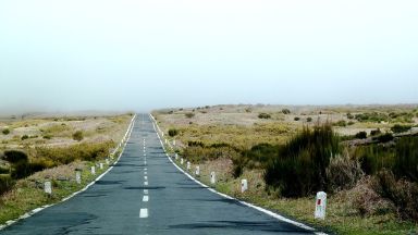
The landscape of Paúl da Serra is defined by vast open spaces, rolling hills, and rugged terrain, primarily adorned with lush grasslands and heather. This creates a picturesque yet somewhat desolate ambiance. The plateau is often enveloped in mist and clouds, enhancing its mystical allure. During the summer, locals gather wild blackberries and bilberries in the area.
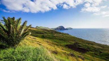
Paúl da Serra serves as a popular destination for nature enthusiasts, hikers, photographers, and tourists seeking to explore the unique natural beauty of Madeira. Numerous walking trails and viewpoints offer opportunities for visitors to immerse themselves in the serene surroundings and capture breathtaking vistas of the island’s mountains, valleys, and coastal areas.
Beyond its natural allure, Paúl da Serra plays a vital role as a water catchment area for the island. Several levadas originate from the plateau, supplying essential water resources for agricultural activities in the lower regions of Madeira.
Among the noteworthy features of Paúl da Serra are its remarkable viewpoints (Miradouro) that offer superb vistas of the surrounding countryside. Visitors often enjoy views looking down over clouds or fog. Miradouro da Bica da Cana is particularly renowned as one of the best places to admire the stunning scenery in this captivating region.
Levadas and Walks in the Paul da Serra Region
In the Paul da Serra region, the most renowned hiking paths include the Levada do Risco (PR5.1), the Vereda das 25 Fontes (PR 6), the Vereda do Fanal (PR13), and the Levada do Alecrim.
The Paul da Serra appears in our Complete Guide to Visiting Calheta (Madeira)!
This website uses affiliate links which may earn a commission at no additional cost to you!
Visiting Paul da Serra
Nearby Attractions
- Levada das 25 Fontes (PR6 & PR6.1) (3.5) km
Hike in Ribeira Brava (Madeira) - Miradouro do Véu da Noiva (6.5) km
Viewing Point and Waterfalls in Porto Moniz (Madeira) - São Vicente, Madeira (7.0) km
Village in Porto Moniz (Madeira) - Fanal Forest (Madeira) (7.1) km
Hike and Natural Phenomenon in Porto Moniz (Madeira) - Seixal (7.2) km
Beach and Village in Porto Moniz (Madeira) - Cascata dos Anjos (8.1) km
Waterfalls in Calheta (Madeira) - Espírito Santo Chapel, Calheta (8.4) km
Church in Calheta (Madeira) - Calheta Beach (8.7) km
Beach in Calheta (Madeira) - Casa Dos Mudas (8.7) km
Arts Venue and Museum in Calheta (Madeira) - Engenho da Calheta (8.8) km
Museum in Calheta (Madeira)


