Port Carlisle
Village near Carlisle
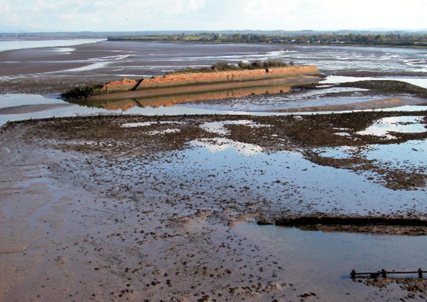
Port Carlisle is a small coastal village in Carlisle, England, on the edge of the Solway Coast Area of Outstanding Natural Beauty. It is best known as the former seaward outlet for Carlisle, where a canal once connected the city to the Solway shore. The place today is quiet and open, with lanes, marshland, and scattered remains of its port and transport past.
Visitors come for the surviving traces rather than a built-up attraction: the old sea lock, canal route, bridges, and shoreline structures still mark the village’s earlier role in trade and travel. The setting also appeals to people who like tidal landscapes, birdwatching, and low-key heritage stops. It is a good fit for a short visit rather than a full day out, especially if you enjoy comparing ruined infrastructure with the surrounding salt marsh and changing estuary views.
History and Significance of Port Carlisle
Port Carlisle was developed in 1819 to support Carlisle's growing commercial needs. The canal linking it to the city was designed to handle sailing vessels and barges loaded with grain, raw materials, and local produce. Its eight locks-each an impressive 18 feet wide-allowed boats to travel from the wooden jetty at the Solway shore to the canal basin behind what later became Carr's (formerly McVitie's) biscuit factory.
The canal's route was ingenious: nearly six miles of level waterway from the Solway, followed by six locks clustered over just one and a quarter miles, before another level stretch into Carlisle. Barges were hauled along the canal, enabling goods to reach the city far more efficiently than by road. For a time, Carlisle could even be reached within a day from Liverpool by sea and canal.
Port Carlisle also became an early Victorian tourist destination. In 1844, a set of impressive hot and cold saltwater baths opened, attracting visitors eager for health and leisure experiences along the coast.
However, the fortunes of the port shifted dramatically after the construction of the Bowness-on-Solway railway viaduct. Its presence altered deep-water channels, accelerating silting and making navigation increasingly difficult. Within a few years, the canal faced serious financial trouble and was finally closed and drained in 1853. Railway developments replaced canal transport, but the village never regained its former importance.
Things to See and Do in Port Carlisle
The remains of the old port and canal can still be explored along the shoreline. Visitors can see remnants of the sea lock, parts of the jetty, and scattered harbour structures now weathered by time. The former canal route is also visible, running northwest out of the village and roughly following the line of Hadrian's Wall.
Several original canal bridges survive, though their height was altered in the 19th century to allow steam trains to cross-a striking example of how one transport revolution overtook another. A warehouse and a lock cottage remain along the old route, offering atmospheric glimpses of the canal’s working days.
Port Carlisle is also an excellent place for coastal walks, birdwatching, and photography, with sweeping views across the Solway Firth to Scotland. Low tides reveal mudflats teeming with wildlife, while high tides bring shimmering reflections of sky and sea.
How to Get to Port Carlisle
Port Carlisle lies west of Carlisle near the Solway estuary. Travellers flying into the region will most likely arrive via Newcastle International Airport, with onward train or car travel to Carlisle. For the best deals and a seamless booking experience, check out these flights to Carlisle on Booking.com.
Carlisle Railway Station offers frequent connections from major UK cities; from the station, Port Carlisle is accessible by local bus or taxi. Train schedules and bookings can be found on Omio. Drivers can reach the village via the A689 or Bowness-on-Solway road, with on-street parking available in the village.
Practical Tips on Visiting Port Carlisle
- Best time to visit Port Carlisle: Around high tide for scenic water views or low tide for wildlife and saltmarsh landscapes.
- Entrance fee in Euros: Free; the coastal paths and ruins are open-access.
- Opening hours: Open at all times; best explored in daylight.
- Official website: Check Solway Coast AONB pages for route and wildlife information.
- How long to spend: 1 to 2 hours depending on walking routes and interest in ruins.
- Accessibility: Mostly level but with uneven ground near the shore and canal remnants.
- Facilities: Limited services in the village; more cafés and shops in nearby Bowness-on-Solway.
- Photography tip: The old canal bridges and shoreline offer excellent compositions at golden hour.
- Guided tours: Occasional local heritage walks explore the canal and port history.
- Nearby food options: Pubs and cafés in Bowness-on-Solway and Carlisle.
Where to Stay close to Port Carlisle
While Port Carlisle itself is small, there are excellent nearby options. Consider The Halston for a comfortable city base within easy reach of the coast. For a village stay near Hadrian's Wall, The Kings Arms offers charm and proximity to walking routes. Another option is Pinegrove Hotel, providing convenient access to both Carlisle and the Solway Coast.
Is Port Carlisle Worth Visiting?
Yes. Port Carlisle offers a fascinating blend of coastal scenery, historic industrial remains, and a peaceful rural atmosphere. Its story-shaped by canals, tides, industry, and early tourism-adds depth to any exploration of the Solway Coast AONB or Hadrian's Wall country. Whether you're interested in history, nature, or quiet walks by the water, it's a rewarding and atmospheric place to explore.
FAQs for Visiting Port Carlisle
The Port Carlisle appears in our Complete Guide to Visiting Carlisle!

Moira & Andy
Hey! We're Moira & Andy. From hiking the Camino to trips around Europe in Bert our campervan — we've been traveling together since retirement in 2020!
This website uses affiliate links which may earn a commission at no additional cost to you!
Planning Your Visit
Nearby Attractions
- St Michael's Church (2) km
Church - Drumburgh Castle (3.1) km
Castle - Solway Junction Railway (3.2) km
Historic Site - Burgh by Sands (8.9) km
Village - Cumbria Museum of Military Life (16.4) km
Museum - Carlisle Castle (16.4) km
Castle - Tullie House (16.5) km
Gallery and Museum - Carlisle Cathedral (16.7) km
Cathedral - Guildhall Museum (16.8) km
Historic Building - Rickerby Park Tower (17.7) km
Tower