Hadrians Wall - Day 1 - Bowness-on-Solway to Carlisle
This website uses affiliate links which earn a small commission at no additional cost to you.
Due to logistics, I had decided that it was easier to stay in Carlisle for two nights and take the bus out to the starting point of Bowness-on-Solway on the first morning.
Bowness-on-Solway is the site of the second largest Roman fort, Maia and this section of the walk enjoys coastal views across the Solway Firth to Scotland. The first few miles you walk along the Solway Coastal Area of Natural Beauty.
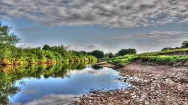
As you reach Burgh by Sands the risk of wet feet you leave the road to walk along the River Eden in to Carlisle – Carlisle was a key settlement during Roman times serving Hadrian’s Wall Forts.
Bowness-on-Solway to Port Carlisle
If you arrive by bus you will be at the Kings Arms in Bowness-on-Solway. Head west along the main road.
You are now walking along the via pinciplaes or main street of Mais, the 16th Roman Fort along Hadrians Wall. Although there are no visible remains excavations in 1930, found the southern rampart and the west gate. The first fort was built of turf and wood probably towards the end of the 120s AD. Like with the entire western wall it was replaced with stone probably about 40 years later. Bowness-on-Solway was also the location of the 80th Mile fort which was probably destroyed when the fort replaced it. The size of the fort and fact that an altar dedicated by a tribune indicated it was a large garrison, probably about 800 with 10 centuries.
You will arrive at the small car park at the west end of the village of Bowness and survey the vast estuary that is the Solway Firth.
Looking to the west you can see the remains of the bridge that used to carry the Solway Junction Railway across the water to Scotland. In 1934 the viaduct was demolished.
Although Bowness-on-Solway is the last fort on Hadrian’s Wall, according to Bishop Nicholson, writing in 1707, the terminus of the Wall lay a quarter of a mile west of the village and other writers confirm his observation. Bowness-on-Solway on a conveniently raised ground of the drumlinoid, is that it is (or was) the lowest fording point of the Solway Firth. A drumlinoid is a low oval mound or small hill, typically moulded by past glacial action.
Look back to the village and you can see the low drumlinoid that provides the slightly elevated platform for the fort of Bowness-on-Solway. Head back through the village and pass the Kings Arms pub. You can detour by turning left before the pub to see the 12th century, St Michael’s Church. Back on the main road, past the pub you should see a sign pointing me down to the Path Pavilion at the Banks, which is the official start/end of the walk.
In the early days of the Twentieth Century, The Banks was a Promenade, a place where Edwardian visitors to Bowness could walk, or sit on the grass or in the shelter and take in the beauty of the Solway. In 2002 The Banks was officially designated the end of Hadrian’s Wall Trail and underwent a renovation, mainly by volunteers from the village. The Roman-style mosaic was created by selecting drawings provided by the children of Bowness on Solway Primary School. If you are collecting the stamps for the https://trailgiftshop.co.uk/HWP-Passport-2016 then you can pick your up here, in the King’s Arms pub, or behind the pub in Lindow Hall.
Walk through the pavilion under the sign which states that Wallsend is 84 miles away and that “Good luck go with you“. The walk along The Banks doesn’t last for long and you soon are back on a quiet lane, which heads across Bowness Marsh with the foreshore to the left. Unless you are knee deep in water don’t worry about the signs warning you of occasional flooding.
The line of the wall runs across farmland, whilst the path sticks to the shore line. Head in the direction of Port Carlisle, which was about a mile away. You can’t follow the Wall exactly so stick to the road and National Trail – the original line can be seen from tree line to your left however. By the time you have arrived at Port Carlisle you will have passed two wall turrets and Hadrian’s Wall Milecastle 79 – Solway House.
Read our Bowness-on-Solway Travel GuidePort Carlisle to Drumburgh
At the small village of Port Carlisle the road curves to the right, and you will need to turn left on the path indicated by the wooden National Trail signpost.
You can take a small diversion here, walk 30m along the main road into Port Carlisle and look for an altar built into the front of the first house on the left. Just above the door lintel you should be able to see the words “MATRIBVS SVIS”. Only the tops of the next word “MILITES” are visible. The whole thing reads ‘to their own mother goddesses, the solders…’.
Back to the trail you walk a long a track that skirts the foreshore on the left. It crosses the mouth of an old canal lock, now only recognizable by ruined brickwork, and continue along a gravel track.
This is the remains of the Carlisle Canal opened in 1823, which linked Carlisle to the Solway Firth, for the transportation of goods. You can look out and see the red sandstone bricked coaling wharf, disconnected from the shore, where boat loads of coal come up from Liverpool would be unloaded into canal barges. The canal was a short-lived venture, closing in 1853, being replaced by a railway which used the canal bed for most of its route in 1854.
The path runs along the foreshore, before joining the course of the Wall ditch and the route of the Port Carlisle Railway. Near the position of Turret 78a, the Trail departs from the course of the ditch. As you cross the road to the Cottage and Glendale Holiday Park, Milecastle 78 is on your right. Before the park gates you turn left along a track that runs southeastwards for a little over half a mile; this is following the course of the Vallum of Hadrian’s wall, whilst off to the left is the embankment of the old railway line to Bowness. The track curves to the left and then the right before emerging onto a road opposite the Highland Laddie Inn in the village of Glasson.
The path turns to the right, but you could make a short detour and head left to have a look at the site of Milecastle 77 – Raven Bank. Follow the road for 0.4km to the T-junction, the Wall is directly under the road and the milecastle lies 50m to the south of the junction. The area was excavated in 1973, but the results were inconclusive.
Head back to the official trail and towards the village of Drumburgh. On the last stretch of the walk the Trail runs on the route of the dismantled Carlisle and Silloth Bay railway.
Read more about Port Carlisle
Drumburgh to Burgh by Sands
Drumburgh is situated on another drumlinoid and on the east side of the village Milecastle 76 would have been located on its eastern extremity. Its westerly Turret, 76A was found in 1948 just east of “Drumburgh schoolhouse”. Drumburgh does have its own mini-castle or ‘bastle’. Which was built using stones taken from Hadrian’s Wall and uses Roman altar stones as garden ornaments. The castle was an important defensive structure for the villagers from the Scottish Border Reivers.
Continue out of the village to the point where the ground slopes down to the low marsh, with more warnings about flooding. The Wall crossed Burgh Marsh although nothing of the curtain wall or its associated components has ever been found. The official path is along the road, although you could very easily walk along the raised bank to the right of the road is an old railway line.
You rise out of the march by the hamlet of Dykesfield, to the north of which is the site of Milecastle 73, which was located and partially excavated in 1948. To the west of which is the enigmatically titled Watch Hill, a local high point, so named after the as “in ancient times there was a watch tower on the spot” (A History of Northumberland – ) – presumably referring to the remains of the Mile Castle.
Although there are no visible remains now, you pass by Turret 72B (Rindle Hill), which was located and partially excavated in 1948.
Location: Drumburgh Castle, Drumburgh, Wigton, UK
Read more about Drumburgh Castle
Burgh by Sands to Carlisle
You will soon arrive in Burgh-by-Sands which is roughly the halfway point of today’s walk and the Greyhound Inn is the perfect place to stop for lunch. Next to the pub there is a park, which has a statue of King Edward I, who died here in 7th July 1307.
The site of Milecastle 72 (Fauld Farm), to the north-east of the post office, was located and partially excavated in 1960.
Walk through the village to the highest ground at the east of the village.
When you reach Michael’s church you are in walking in middle of the Roman fort of Aballava. Aballava literally means ‘apple’ but is thought to mean ‘The Orchard’. Although there are no visible remains many of the buildings and much of the church are built out of the red sandstone blocks originally used for the curtain wall and fort. The fort originally straddled the turf Wall, it followed the line of the road. The garrison, possibly, was a mixed cohort about 500 strong from Belgium.
There are sites of two other older forts near the village (see map). The oldest is a late-1st-century AD turf-and-timber fort, possible an extension to the Stanegate system of forts, which were forts built along the important Roman Road called Stanegate or “stone road” which linked Carlisle to Corbridge. The other is thought to be an early Hadrianic Wall Fort from 120AD. There was a vicus to the south-west of the fort, and it is believed that a cemetery existed to the south of the fort.
After exploring the Church and refilling your bottles at the tap at the back, return to the main road. Pass the graveyard on your left, which is built over the garrison halls of the fort, and pass through the kissing gate just beyond it, which is the probably site of Turret 71B. The path follows the line of the road, and the wall, for about 150m before rejoining the road and then turn north up a track.
In the field you just left was the site of Burgh Castle, which excavations between 1948 and 1950 uncovered the site of a mid 13th century moated manor house consisting of a hall and a possible pele tower, on the site of a probable Norman motte and bailey castle. The barony of Burgh-by-Sands, founded by Ranulph Meschin c1100, reached a peak of prosperity in 1314, but suffered greatly from the 14th century Scottish raids. An inquisition of 1362 showed the manor house to be in ruins. The site of the manor is known as Speergarth Holes where there were ancient fishponds and where some oak frames were found. The field to your right is called “spill-blood holme” and, until very lately, an old ash tree stood here, called “hangman’s tree,” on which, it is presumed, many victims of those feudal lords were executed.
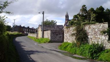
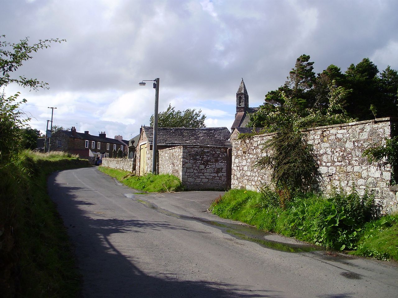
By the time you reach the top of the field we are walking alongside the wall again and just past its north east corner, across the stream is the site of Turret 71a. The trail follows the wall past the sites of Milecastle 71 (Wormanby) and Turret 70b, until you come to the village of Beaumont. As you head into the village at the triangular green admire the raised mound upon which is situated St Mary’s church to your right.
The mound is the location of Turret 70a and is also all that remains of the timber motte castle is thought to have been constructed by the le Brun family during the 12th century. In 1306 Sir Richard le Brun was lord of Beaumont but removed his residence to Drumburgh Castle, which we saw earlier in the day. The church was built here by the Normans in 1296 and it was restored in 1872.
The Trail leads off to the left out of the village and towards the River Eden. The path leaves the road to the right as you reach the river. You will pass the position of Milecastle 70 (Braelees) which is thought to be perched on the edge of the cliff above the Eden. The Wall and the path leave the river and follows the high ground past the village of Kirkandrews-upon-Eden. Turret 69B is probably located beneath the site of St Andrew’s Church in the village of Kirkandrews-on-Eden. You will come to a small bridge called Sourmilk Bridge which is the near the probably position of Turret 69A. Sourmilk Bridge crosses the Double Beck, and near Mill Beck – Beck is the work for stream used in Lincolnshire to Cumbria in areas which were once occupied by the Danes and Norwegians.
At the village of Grinsdale the path turns to the right along the road and then to the left to follow the path of the wall. The Wall is marked by a hedgerow and due to the proximity of the riverside the defensive ditch not needed. Cross over the footbridge of Boomby Gill, is the probably site of a Milecastle 68. A gill or ghyll is a ravine or narrow valley in the North of England and other parts of the United Kingdom and originates from the Old Norse gil. The stream flowing through a gill is often referred to as a beck.
After Boomby Gill you should be able to see the vallum to your right. You will enter into woods and pass the unlocated Milecastle 67 (Stainton). You continue along the river as you pass industrial parts of Carlisle, while the wall cuts straight across to Bitts Park, on the floodplain of the Eden and just north of Roman Carlisle.
Hadrians wall crossed the Caldew and the Eden via stone bridges. The stones from one or both of the bridges can be seen in Bitts Park, which is the endpoint of the days walk.
Location: Burgh by Sands, Carlisle, UK | Hours: 24 Hours | Price: Free
Read more about Burgh by Sands
Thats it for the day, but if you have time, you can explore Carlisle. You will be close to Carlisle Castle which is on the site of the fort of Luguvalium, which predated Hadrian’s Wall and formed part of the Stanegate forts.
The modern bridge over the river Eden, was probably the site of the Roman road bridge. Tomorrow the National Trail will take you along the river away from the wall for a few miles. It may by worth crossing over the river to have a look and the site of the third Wall Fort – Stanwix Fort.
Also Tullie House’s large collection of Roman artefacts and a a full-height reconstruction of a section of Hadrian’s Wall .
This website uses affiliate links which earn a small commission at no additional cost to you.