Hike the GR34 2026: 5 Unforgettable Day Hikes on Le Sentier des Douaniers

This website uses affiliate links which earn a small commission at no additional cost to you.
If you’ve ever dreamed of walking along the edge of the world, the GR34 delivers. Known in French as Le Sentier des Douaniers, or the Customs Officers’ Path, this iconic trail snakes for more than 2,000 kilometers along Brittany’s wild and dramatic coastline. It was once patrolled by customs agents watching for smugglers; today, it offers hikers an immersive journey through windswept cliffs, golden beaches, sheltered coves, and ancient villages.
While thru-hikers may spend weeks on the full route, some of the GR34’s greatest treasures can be found in short, well-marked day hikes. From the pink granite boulders of the north coast to the fierce headlands of Finistère and the tranquil Gulf of Morbihan, each section brings its own rhythm, scenery, and sense of place. Whether you’re looking for a leisurely walk or a more demanding day on the trail, there’s a stretch for every kind of walker.
In this guide, we’ve chosen five unforgettable day hikes that showcase the diversity and beauty of the GR34. Each one offers a distinct experience-whether it’s natural wonder, historical intrigue, or culinary reward. Lace up your boots, grab a map, and discover Brittany on foot, one breathtaking vista at a time.
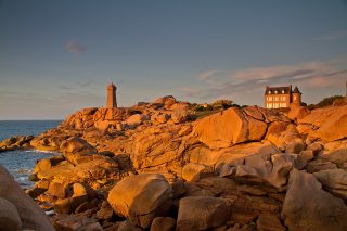
1. The Pink Granite Coast: Ploumanac’h to Trégastel

Distance: ~7 km (plus 3 km return)
Start/Parking: Point de vue Turquet de Beauregard
This scenic walk between Ploumanac’h and Trégastel reveals the otherworldly beauty of Brittany’s Côte de Granit Rose. Towering boulders in hues of pink and gold are scattered across beaches and headlands, shaped by centuries of salt and wind. Along the way, you’ll pass the famous Ploumanac’h lighthouse and panoramic viewpoints over the Sept-Îles. The contrasts between sea, stone, and sky make this one of the most visually captivating walks in all of France.
Interpretive panels along the path explain the geological formations and local legends tied to the landscape, while occasional beach access points allow for detours onto soft sand or rocky pools teeming with marine life. Wildflowers and wind-sculpted trees dot the route, and cafés in Trégastel provide a welcome stop at the end of the walk.
The trail is mostly flat and family-friendly, making it suitable for all ages and abilities. Whether you’re walking for an hour or an afternoon, this stretch of the GR34 offers a magical glimpse into Brittany’s coastal character and a kaleidoscope of natural color.
Location: Ploumanac'h lighthouse, Perros-Guirec, France

2. Pointe du Raz & Cap Sizun: Trépassés Beach to Pointe du Van

Distance: 8.5km
Start/Parking: Plage de la Baie des Trépassés
This 8.5-km loop trail near Plogoff, Finistère offers a moderate challenge, taking around 2 hours and 24 minutes to complete. The route is a favorite among hikers, birdwatchers, and runners, with frequent visitors throughout the year. Open in all seasons, the trail presents stunning landscapes at any time, and dogs are welcome, with some areas allowing them off-leash.
Pointe du Raz, a striking rocky headland, marks the western tip of Cap Sizun and overlooks the Iroise Sea. Rising 72 meters above the Raz de Sein strait, it offers dramatic views of the powerful waves and strong tidal currents that have shaped its reputation. Recognized as a Grand Site de France, this coastal landmark is one of the most iconic destinations in Brittany.
The trail begins at the Trépassés beach car park, leading along the coastline toward Pointe du Raz. Along the way, you’ll encounter Notre-Dame des Naufragés, a beautiful marble sculpture created by Cyprien Godebski, standing as a tribute to sailors lost at sea. You will also come across the Blockhaus de Men Tan, a remnant of World War II fortifications. This site was part of the Atlantic Wall, a defensive network built by the German forces to monitor and protect the coastline. The Men Tan radar station, equipped with long-range Mammut radar, played a crucial role in tracking Allied movements across the English Channel
As you continue, the route passes through Koummoudog Point and the port of Bestrée before veering inland. The final stretch leads to the chapel of Saint-Michel in Plogoff, offering a peaceful conclusion to this scenic journey.
Location: Pointe du Raz, Plogoff, France | Hours: Outdoor site accessible year-round; facilities and visitor services may be seasonal | Price: Free to access the headland; parking may be paid depending on the site’s current arrangements. | Website
3. Pointe de Plougrescant

Distance: 13km
Start/Parking: By Camping Beg Ar Vilin
Explore this 13.0-km loop trail near Plougrescant, Côtes-d’Armor, a route offering a moderate challenge with an average completion time of 2 hours and 57 minutes. A favorite among hikers and runners, the trail is well-frequented, making it likely you’ll cross paths with other outdoor enthusiasts. The best time to experience this scenic path is between April and September, when conditions are ideal. Dogs are welcome, though they must be kept on a leash.
This popular hike begins in Plougrescant, winding around the headland that shares its name, following a spectacular coastal path. One of the area’s most famous landmarks is Castel Meur, a stone house dramatically nestled between two massive granite formations near a chasm. While access to the house is restricted due to its private ownership, it remains an intriguing sight along the route.
Location: Castel Meur, Plougrescant, France | Hours: 24 Hours | Price: Free | Website
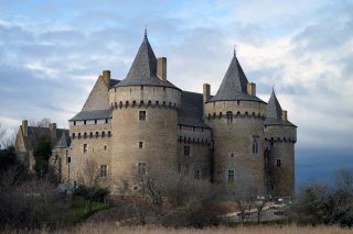
4. Cap Fréhel to Fort La Latte

Distance: 13.2km
Start/Parking: Fort la Latte
This 13.2-km circular trail near Plévenon, Côtes-d’Armor offers a fantastic blend of natural beauty and historical intrigue. Considered a moderately challenging route, it takes approximately 3 hours and 29 minutes to complete. Popular among hikers and runners, the trail is accessible year-round, welcoming dogs on a lead.
The journey will take you through the breathtaking landscapes of Cap Fréhel, renowned for its dramatic cliffs that rise over 70 meters above the sea. Composed of pink sandstone and shale, the cape is home to a protected bird reserve and a towering lighthouse that has guided sailors along Brittany’s rugged coastline for centuries.
Following the path along the cliffs, you’ll arrive at Fort La Latte (Château de La Roche Goyon), a striking medieval fortress built in the 14th century. Originally designed as a coastal defense, the fort saw significant reinforcement under Louis XIV. With its imposing towers, drawbridges, and commanding sea views, it offers incredible photo opportunities—just be sure to check the opening hours if you wish to explore its historic interiors.
For your return journey, you can retrace your steps or opt for a slightly shorter route through the countryside.
Location: Cap Fréhel lighthouse, Plévenon, France | Hours: (Winter) Thursday – Sunday: 14:00–17:30. (Summer + school holidays) Daily: 14:00–17:30. | Price: Adults: €3 | Website
5. Pointe du Grouin - Pointe du Chatry

Distance: 7.2km
Start/Parking: Parking Plage du Saussaye
Starting from the Pointe du Grouin car park, the trail follows a section of the renowned GR® 34, a long-distance coastal path that showcases Brittany’s rugged beauty. As you make your way along the cliffs, you’ll be treated to panoramic views of the Île des Landes and the Bay of Mont Saint-Michel, a UNESCO World Heritage site known for its dramatic tides and historic abbey.
Along the route, you’ll encounter several fascinating landmarks. The Groin Semaphore, a maritime signal station built in 1861, has long played a role in coastal navigation, standing as a testament to the region’s nautical heritage. The beaches of Saussaye and Port-Mer provide serene spots to pause and absorb the coastal ambiance, offering a peaceful contrast to the dramatic cliffs. Further along, the Hermit Cave, a mysterious sea grotto nestled at the tip of Grouin, adds an intriguing element to the journey.
With its combination of natural beauty, historical significance, and diverse landscapes, this trail is a must for outdoor enthusiasts. Whether you’re looking for a peaceful walk, a photography adventure, or a chance to immerse yourself in Brittany’s coastal heritage, this route promises an unforgettable experience.
Location: Pointe du Grouin, Cancale, France | Hours: 24 Hours | Price: Free | Website
The GR34 isn’t just a path-it’s a portal into Brittany’s soul. Whether you’re hiking for half a day or planning a longer adventure, these day hikes offer a perfect blend of scenery, history, and Breton spirit. With GPX points and manageable distances, each section is a rewarding chapter in your own coastal story.
Tip: Always check tide charts and weather before setting out, and bring windproof layers-even in summer.

Moira & Andy
Hey! We're Moira & Andy. From hiking the Camino to trips around Europe in Bert our campervan — we've been traveling together since retirement in 2020!
This website uses affiliate links which earn a small commission at no additional cost to you.
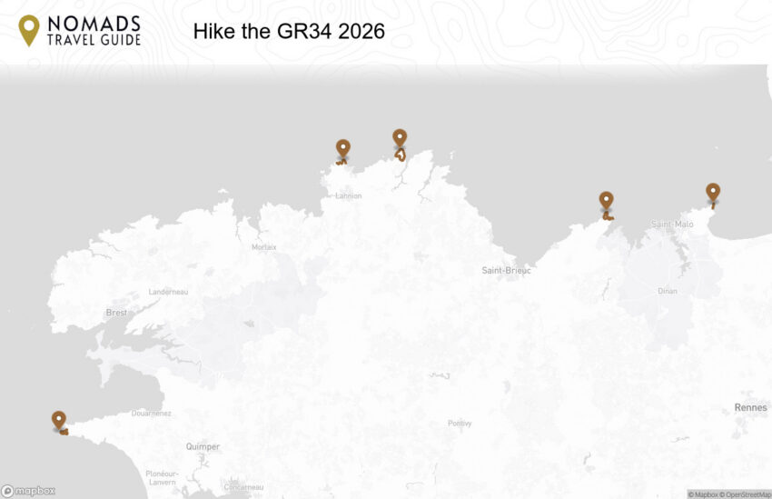
Walking Tour Summary
Distance: 49 km
Sites: 5
Walking Tour Map