Republic of Kiribati: The Ultimate Travel Guide 2026
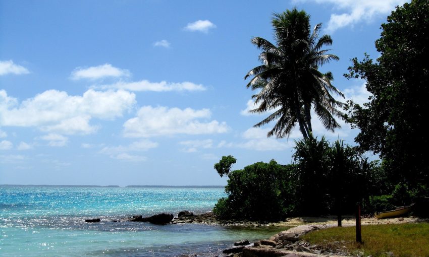
The Republic of Kiribati is a Pacific island nation made up of 33 low-lying atolls and reef islands scattered across a vast stretch of ocean. Its territory spans three main island groups-the Gilbert, Phoenix, and Line Islands-placing it among the most geographically dispersed countries in the world. With turquoise lagoons, coral reefs, and wide open seascapes, Kiribati’s environment is closely tied to the rhythms of the ocean and the land.
Life in Kiribati is shaped by island communities, strong family networks, and a rich cultural identity rooted in the I-Kiribati people. Local traditions, storytelling, dance, and communal gatherings remain central to daily life, alongside a growing connection to modern education and services. The capital area, South Tarawa, is the country’s main hub for government, commerce, and transport, while many outer islands maintain a quieter, more traditional pace.
Kiribati is also widely known for the opportunities and challenges that come with being a low-lying island nation. Its economy relies on a mix of fishing, public services, remittances, and international partnerships, with the ocean playing a central role in livelihoods and national planning. At the same time, Kiribati is often highlighted in global conversations about climate resilience, as communities work to protect freshwater supplies, coastlines, and homes in the face of environmental change.
Table of Contents
- History of Republic of Kiribati
- Origins and early settlement
- Regional networks and first European sightings
- Whalers, traders, and disruptive contact
- Colonial rule: the Gilbert and Ellice Islands
- World War II and the Battle of Tarawa
- Postwar change and the road to self-government
- Separation from Tuvalu and independence
- Early nationhood and economic foundations
- International profile and the date line change
- Climate era politics and adaptation
- Best Time to Visit Republic of Kiribati
- Food and Drink from Republic of Kiribati
History of Republic of Kiribati
Kiribati’s history is shaped by its geography: widely scattered atolls across the central Pacific, long-distance ocean voyaging traditions, intense encounters with whalers and traders, colonial rule under Britain, and a late-20th-century path to independence that left enduring questions about land, identity, and survival in a changing climate.
Origins and early settlement (before 1500s)
The islands now forming Kiribati were settled by Micronesian-speaking peoples over many centuries, with later waves of movement and intermarriage from Polynesian and Melanesian neighbors. Communities developed sophisticated navigation and seafaring skills, and social life centered on extended kin groups, land rights tied to lineage, and village decision-making. Distinct local identities formed across the Gilbert, Phoenix, and Line Islands, reflecting distance and differing ecological conditions.
Regional networks and first European sightings (1500s–1700s)
European explorers began sighting parts of the archipelago from the 16th century onward, but sustained contact was limited for a long time. Islanders continued to rely primarily on inter-island exchange, voyaging, and regional relationships, with local conflict and alliance patterns shaped by land scarcity and chiefly authority in some areas.
Whalers, traders, and disruptive contact (1800s)
In the 19th century, contact intensified as whalers, beachcombers, and traders arrived more frequently. New goods and technologies entered island life, but so did disease and social disruption. Missionaries expanded Christianity, which gradually became a major force in education, community organization, and politics. The period also saw the rise of labor recruitment and coercive practices in the Pacific, including “blackbirding,” which affected many island societies and contributed to demographic and social strain.
Colonial rule: the Gilbert and Ellice Islands (1892–1941)
Britain declared a protectorate over the Gilbert Islands in 1892, later administering them together with the Ellice Islands as the Gilbert and Ellice Islands Colony. Colonial governance introduced new legal systems, taxation, and administrative structures, while mission schools and church networks expanded literacy and new forms of leadership. Economic life increasingly connected to global markets through copra production, though opportunities were uneven and constrained by the atolls’ limited resources.
World War II and the Battle of Tarawa (1941–1945)
Kiribati’s central location made it strategically important during World War II. Japan occupied parts of the Gilberts, fortifying key islands. In November 1943, the Battle of Tarawa—fought primarily on Betio islet in South Tarawa—became one of the war’s most intense amphibious assaults, with heavy casualties and lasting local impact. The war left physical destruction, unexploded ordnance, and profound memories that shaped postwar politics and identity.
Postwar change and the road to self-government (1945–1970s)
After the war, colonial administration resumed amid growing global decolonization. Political participation expanded gradually through local councils and representative institutions. Education and public services improved, and islanders increasingly engaged with wage labor and migration, including movement to South Tarawa as the administrative center grew. Debates over identity and governance intensified, particularly as the Ellice Islands pursued separation.
Separation from Tuvalu and independence (1975–1979)
In the mid-1970s, the Ellice Islands separated to become Tuvalu. The remaining Gilbert Islands moved toward independence, adopting the name “Kiribati” (a local rendering of “Gilberts”). Kiribati became an independent republic on 12 July 1979. The new state inherited the challenges of governing a vast ocean territory with a small population, limited land, and heavy dependence on external revenue and aid.
Early nationhood and economic foundations (1980s–1990s)
Post-independence governments focused on building national institutions, expanding education and health services, and managing scarce resources. A key economic pillar became the Revenue Equalization Reserve Fund, built from phosphate mining proceeds from Banaba (Ocean Island), mined largely during the colonial era. Banaban displacement and land rights remained a sensitive national issue, with many Banabans living on Rabi Island in Fiji while maintaining claims and ties to Kiribati.
International profile and the date line change (1990s–2000s)
Kiribati gained visibility through ocean governance and climate diplomacy, advocating for the interests of low-lying atoll states. In 1995, Kiribati adjusted its time zone arrangements so that all its islands shared the same calendar day, effectively moving the International Date Line eastward around its territory. This reinforced administrative unity across the widely dispersed Line and Phoenix Islands and drew global attention.
Climate era politics and adaptation (2000s–present)
Rising sea levels, coastal erosion, saltwater intrusion, and changing weather patterns have made climate change a central national concern. Kiribati has pursued adaptation measures such as coastal protection, water security projects, and land-use planning, while also engaging internationally on emissions and climate finance. Population growth and internal migration—especially toward South Tarawa—have increased pressure on housing, sanitation, and freshwater supplies.
Kiribati’s modern history is thus a story of resilience and continuity: maintaining cultural identity and community governance across far-flung atolls while navigating the legacies of colonialism, wartime trauma, economic constraint, and the existential risks posed by climate change.
Best Time to Visit Republic of Kiribati
Visiting Republic of Kiribati in Spring
Spring (roughly March to May) is a strong choice if you want warm weather with fewer crowds and good conditions for lagoon time, snorkeling, and outer-island visits. Seas can be more changeable than mid-year, but this period often balances sunshine with manageable humidity—ideal for travelers who prefer a quieter, more local feel.
Visiting Republic of Kiribati in Summer
Summer (roughly June to August) is popular for drier, breezier days and generally comfortable conditions for beach time, fishing, and exploring South Tarawa and nearby islets. This is also a good window for cultural experiences—Independence celebrations around early July can be a highlight, with performances, community events, and traditional dance.
Visiting Republic of Kiribati in Autumn (Best)
Autumn (roughly September to November) is often the sweet spot for reliably pleasant weather—warm, relatively dry, and less humid than the wetter months. It’s a great time for lagoon activities, diving/snorkeling visibility, and travel between islands when conditions cooperate. If you’re looking for the best overall mix of weather and ease of travel, this is typically the most dependable season.
Visiting Republic of Kiribati in Winter
Winter (roughly December to February) tends to be hotter and more humid, with a higher chance of heavy showers and unsettled conditions. It can still be rewarding if you don’t mind tropical rain—landscapes feel lush, and you’ll often find fewer visitors. Plan with flexibility for weather-related changes, especially if you’re aiming to connect onward to outer islands.
Food and Drink from Republic of Kiribati
Food and drink in the Republic of Kiribati are shaped by its low-lying coral atolls, the surrounding Pacific Ocean, and a long tradition of living from what can be fished, gathered, or grown in sandy soils. Everyday meals often center on seafood—especially reef fish, tuna, and shellfish—paired with starchy staples and simple preparations that suit island life. Because arable land is limited, many households rely on a mix of local foods and imported goods, with cooking methods ranging from boiling and grilling to earth-oven style baking for larger gatherings.
Seafood is the backbone of the Kiribati diet. Fish may be eaten fresh, grilled, baked, or cooked in coconut cream, and it’s common to see simple seasonings that let the flavor of the catch stand out. Coastal foraging and lagoon fishing contribute variety, while preserved or dried fish can be important when weather or distance makes fresh supply harder. In celebrations and communal meals, larger fish and shared platters reflect the social nature of eating together.
Key land-based staples include coconut, breadfruit, pandanus, and taro (where it can be cultivated), along with bananas and other hardy plants. Coconut is especially versatile: the flesh is eaten, the cream enriches sauces and stews, and the sap can be collected for sweet uses. Breadfruit may be roasted or boiled, pandanus can be eaten fresh or processed into longer-lasting forms, and these foods help balance meals when fishing is less productive. In many homes, imported rice, flour, sugar, and canned foods also play a significant role, particularly in urban areas.
Drinks in Kiribati range from fresh coconut water to beverages made from local plant resources, alongside widely available imported soft drinks, tea, and coffee. Coconut water is a natural refreshment in the heat, and coconut-based preparations can appear in both food and drink. In some communities, sweet sap collected from coconut or other palms is used as a traditional beverage or ingredient, while modern store-bought drinks are common at gatherings and in day-to-day life. Overall, what people drink—like what they eat—reflects a blend of island tradition and the realities of supply across a far-flung nation of atolls.