Hadrians Wall - Day 4 - Cawfields to Chollerford
This website uses affiliate links which earn a small commission at no additional cost to you.
You start at the Great Whin Sill at Cawfields Quarry – the volcanic plateau which large sections of the Wall are built on, before descending to Once Brewed and a visit to The Sill: National Landscape Discovery Centre.
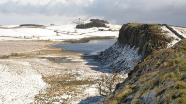
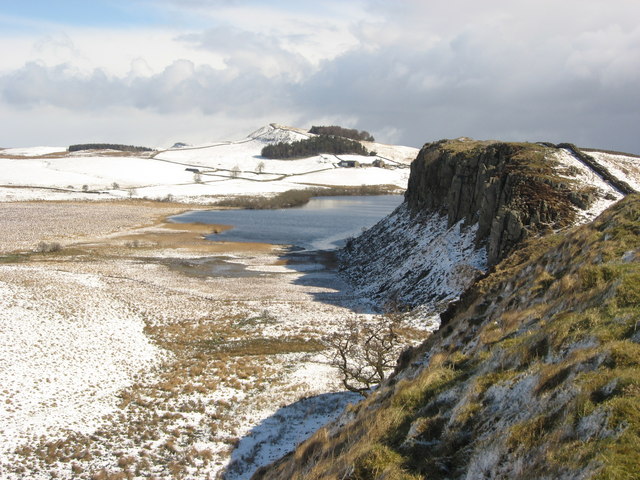
Heading out from Once Brewed you’ll soon be up on the Wall again and viewing one of the trails best scenes. Steel Rigg offers views from Peel Crags to Crag Lough with the Wall cresting above them. A mile along Peel Crags will bring you to one of the most iconic places on Hadrian’s Wall, Sycamore Gap. Take a moment to witness this famous spot, but don’t dawdle, as ahead are crags, loughs, ancient temples and the Forts of Housesteads and Chesters.
Cawfields Quarry to Steel Rigg
Head back to Milecastle 42 (Cawfields) and head east gradually climbing along the edge of Cawfields Crags.
Unlike the Ministry of Works who prefer to leave monuments ‘as found’, John Clayton, who owned this stretch of land during the 19th century, had his workmen consolidate the wall with the stones that lay to either side of it.
Before long we pass the site of Turret 41b, of which there are no visible remains, before encountering a small gate through the curtain wall which is called is Thorny Doors. Immediately afterward this there is a steep climb and we pass the highest surviving piece of unreconstructed curtain wall (11 courses of stone).
As we walk along the plateau we pass the remains of Turret 41a (Caw Gap) which was excavated in 1912. It had been deliberately demolished when the Wall was briefly abandoned when the Antonine Wall was built, although it was consolidated in 1972-3.
We descend into Caw Gap, which has a minor road passing through the wall, and the ditch making a brief appearance to the north.
Directly to the south lies the old Shield-on-the-Wall farm house, which in the 1842 OS map you can see positioned on the wall at Milecaslte 41. It was later moved to its current position, amongst a clump of trees. This area is known as Shield on the Wall – a reference to a group of shielings that sheltered in the lee of the ridge.
To the south lie two standing stones Mare and Foal, which once formed a stone circle about 6m across. The stones were recorded by the Romans at the time of building nearby Chesters Roman Fort. The 1842 OS map refers to them as a “Supposed remains of a Druidical Circle.”
Heading up a stepped path, the crest of the ridge is soon joined again. You need to cross a shallow nick called Bogle Hole Gap, which contains the remains of a neatly set out line of shielings. Bogle means ghost or goblin in Northumbria.
The faint remains of Milecastle 41 (Melkridge) a short-axis milecastle are passed. The Wall itself is poorly preserved hereabouts, and for much of the way there is only a drystone wall. The milecastle is often called Shield-on-the-Wall, after the farmhouse that was moved to the south of Caw Gap.
The climbing continues , taking us past the site of Turret 40b and to another substantial gap, Lodhams Slack, which is broad enough to be defended by the ditch. Slack is a Norse word meaning stream in a valley.
Now we are up on Winshield Crags. We pass the site of Turret 40a and the trig point – at 1,132 feet (345 metres), this is the highest point on Hadrian’s Wall. Take a moment look for the Cheviots to the north, to the south the Cross Fell and far to the west are the hills of the Southern Uplands. Just to the south is a sheltered spot called Green Slack.
Following the ridge gently downhill, the site of Milecastle 40 (Winshields) is passed. It was excavated in 1908 and found to be a long-axis type placed at an angle in the curtain wall, with both gateways reduced to pedestrian-only access at a late date. The milecastle can be seen as turf-covered rubble banks up to 1.0 metre high.
From the moment we leave Milecastle 40, at the eastern end of Winshields Crags, the ditch reappears to the north of the curtain wall and there is a gentle downhill stretch to take us to near Steel Rigg and its car park.
Just before you reach the road, you pass Turret 39b, which was excavated in 1912.
Location: Milecastle 42, Haltwhistle NE49 9PJ, UK | Hours: 24 Hours | Price: Free
Read more about Hadrian’s Wall – Milecastle 42 – Melkridge
Steel Rigg to house Steads
Once we have crossed the road, the National Trail moves to the northern side of the curtain wall and we descend into Peel Gap.
The road to the south leads to the The Twice Brewed Inn and the Once Brewed Youth Hostel (now combined with the Sill National Landscape Discovery Centre). A motorist arriving on the military road from the east will see the village called “Once Brewed”, while those coming from the west will see “Twice Brewed”. One story about the name is that on the eve of the Battle of Hexham in 1464, Yorkist foot soldiers demanded their beer be brewed again because it lacked its usual fighting strength, another explanation is that 18th-century farmers tended to brew weak ale, and hence “twice brewed” meant the inn offered stronger ale.
Peel Gap Tower – Excavation in 1987 revealed an additional tower inserted into the Wall scheme, between Turret 39b and Turret 39a (ahead of us, up on Peel Crag), inserted into a blind spot. Archaeologists found the foundations of the tower together with a hearth and a platform for a ladder.
There is little to mark the site of Turret 39a (Peel Crag). We begin to descend into another nick and up the other side which is called Cat Stairs.
At the top we are rewarded with one of the iconic views of the Wall: Milecastle 39 (Castle Nick). The excavated stonework has been consolidated, and the walls are up to 1.75 metres high. The structures visible inside it are for the most part post-medieval possibly used as a milking parlour.
Leaving Castle Nick, we again ascend a small hill on top of which are some medieval shielings, or shepherd’s shelters, tucked up against the south face of the curtain wall.
The Wall now turns sharply and descends into the iconic Sycamore Gap, with its eponymous tree rooted amongst the collapsed curtain wall. Its future has been ensured by planting a replacement slightly to the south within a circular drystone enclosure (called a stell; this is where it was originally situated when Jessie Mothersole walked past in 1921, so the new one is third generation). It is sometimes known as ‘the Robin Hood tree’, as it featured in the 1991 film Robin Hood: Prince of Thieves.
Ascend the winding stairs up to Highshield Crags, at the top, the wall is replaced by a modern drystone field boundary which soon disappears. As you come alongside Crag Lough (pronounced ‘luff’) on the left you pass the site of Turret 38B (Highshield Crag). The path pleasantly passes through some trees at the top of the cliff, as you descend gently into Milking Gap, passing Turret 38A (Milking Gap).
Just as the nicks to the west were formed by glacial meltwater breaching the dolerite ridge of the Whin Sill, so the three prominent lakes north of the Wall (Crag, Broomlee, and Greenlee Loughs) are basins formed by the remnants of that same trapped meltwater.
As we cross the access road to Hotbank Farm, we can clearly see the ditch to the side of us, with the Roman wall sitting below the modern stone wall. At the road we cross to the south side of the curtain wall again. Ascend Hotbank Crag brings us to the remains of Milecastle 38 (Hotbank). Hotbank Milecastle was excavated in 1935.
To the south of us are the remains of the Milking Gap settlement, which consisted of five round stone houses enclosed by a turf wall. It was probably occupied between 120 AD and 180 AD, its inhabitants probably expelled when the vallum was built.
As soon as we have finished with Milecastle 38 we have an steep climb up to Hotbank Crags. Once we reach the top and the wall has again been replaced with a modern drystone wall, and the path then descends into Rapishaw Gap. The bottom is pierced by a gateway that marks the departure of the Pennine Way. Crossing a stile, we are confronted with a prominent outcrop, on top of which is the neatly terminated end of another stretch of consolidated curtain wall. The path heads south for a short way and then almost double back to get up to the line of the wall itself.
At the top the path travels 180m along Cuddy’s Crags to another descent in which is located the iconic Milecastle 37 (Housesteads). Initially made famous by a postcard produced at the beginning of the 20th century by J. P. Gibson, Hexham pharmacist and photographer. It has been excavated four times between the middle of the 19th and end of the 20th centuries. This is one of the best preserved milecastles on the Wall. Part of an inscription found here indicates it was built by the Second Legion. The east half of the milecastle was occupied by barrack blocks for eight men.
After a short walk through some trees we come to Housesteads fort itself.
Location: Hexham NE47, UK | Hours: 24 Hours | Price: Free
Read more about Hadrian’s Wall – Milecastle 37 – Housesteads
Housesteads Fort to Carrawburgh fort
Known as Vercovicium, Housesteads Roman Fort was built during 122-32. Today, you can wander the barrack blocks and the hospital. Peer into the oldest toilets you’ll ever see, and admire the stunning panoramic views. The interactive museum showcases Roman objects and the mini-cinema will take you on a journey through time. Access to the fort is via English Heritage.
Leaving the south-east corner of the fort we can make our way diagonally down the slope towards where the curtain wall crosses the Knag Burn. The valley of the Knag Burn was not only the site of the bath-house for Housesteads but also the Knag Burn Gateway. Knag Burn Gateway, thought to have been built during the 4th century and, consists of two towers, one on either side of a single portal. Which does give us a clue what the other gateways on Roman roads looked like.
The curtain wall, beneath the by-now-familiar field wall, descends into Busy Gap which is breached by a modern gateway called the King’s Wicket. The gap is protected by the Wall ditch and to the north is an earth work that may date as far back as the Bronze Age. The name Busy Gap was probably bushy gap, that is a gap with plenty of bushes. A drove road passes through here and the spot was mush frequented by the moss-troopers and thieves of the middle ages. There is a post medieval triangular earthwork enclosure to the north of busy gap.
Ascending Sewingshields Crags we pass the site of Turret 35b at the top of the ridge, where we have good views of Broomlee Lough, Greenlee Lough beyond it, and Housesteads Crags, with Crag Lough and Peel Crags in the distance.
To the north, north west is the line of the famous Saxon boundary earthwork called the Black Dyke. It consists of a ditch with the earth thrown out on the east side. Old maps show it running from Northumberland to Durham. Local tradition recalls it formed the boundary between the native British Kingdom of Rheged and the Anglo Saxon Kingdom of Bernica. It now looks like a stonewall.
Continuing along past Turret 35a (Sewingshields) is now just an consolidated structure, to the only exposed masonry of Milecastle 35 (Sewingshields). Excavated in 1978–82 the long-axis milecastle was noted not to have a north gate. The interior of the fortification is occupied by several phases of Roman building on either side of the central roadway. The site was reoccupied and used as a medieval farmstead (13th to 16th century) – these remains were removed during excavation.
About 50m on, before you reach the trees, we come to Cats Gate, a narrow chasm in the rocks through which allowed a pict in order to sneak under the curtain wall.
As you walk through the trees, Sewingshields Farm is to your left, and lies over Turret 34B. After we emerge from the trees near Sewing Shields farm and pass a small cottage, to the north are indentations in the field to the north, with are the remains of Sewingshields Castle or its fish ponds.
Sewingshields Castle is referred to by Sir Walter Scot as the Castle of the Seven Shields,- to be worn by seven gallant Knights of the Round Table. Hodgson’s “History of Northumberland” tells that King Arthur, his Queen Guinevere, his court of lords and ladies, and his hounds were enchanted in some cave of the crags, or in a hall below the castle of Sewingshields. Ready to waken and save Britain form peril…
Northwest of Sewingshields lie two high points called King and Queen’s Crag. King Arthur was siting on his crag, and feeling insulted by his queen through a boulder at her, which she deflected with her comb. The boulder now lies between the two.
Just before we cross a drystone wall we come across Turret 34a (Grindon West) which exists as a consolidated structure. The turret was only occupied in the 2nd century and, after abandonment, had its northern recess filled in.
Milecastle 34 (Grindon) has no visible remains and is located within a small, tree-filled, walled enclosure. To the north the ditch reappears since the crags are now behind us and its protection is once more needed.
As we continue the remains of the curtain wall are visible as a low mound with occasional blocks of stone poking out until we reach the remains of Turret 33b (Coesike). It has been exposed, and consolidated to a maximum height of 1.1 metres. You will pass by Turret 33A without noticing it as, although discovered in 1920, nothing now remains.
Location: Hexham NE47, UK | Hours: 24 Hours | Price: Free
Read more about Hadrian’s Wall – Milecastle 37 – Housesteads
Carrawburgh fort - Chollerford
Carrawburgh fort (Brocolita) is one of the 16 forts of Hadrians Wall, it is notable as it sits astride the Wall, rather than attached to the rear or even detached. Carrawburgh housed a garrison of approximately 500 soldiers – first from south-west France, later from southern Belgium – responsible for defending the frontier of the Roman Empire.
There is little to see of the fort, which stands on a bare flat moor, although its platform is still prominent however nearby stands a Temple to the god Mithras, built by the soldiers of Carrawburgh. Immediately outside the entrance at the western end of the mithraeum was another small shrine, dedicated to the nymphs and the genius loci (literally ‘spirit of the place’).
Milecastle 31 (Carrawburgh) lay just beyond the eastern end of the car park, part of one of the robbed walls having been found. Needless to say, there is nothing to be seen now.
Departing Carrawburgh, we head eastwards up the field, past some recent quarrying next to the Military Road, and the Vallum re-emerges, with the Military Way on its north mound. We cross though a gate and back over the Military Road, backtracking slightly to get into the field and resume the Trail to the north of the ditch.
The other side of the road we pass the next two turrets. Turret 30B (Carrawburgh West), was discovered in 1912 as a low mound west of the track to Carrawburgh Farm, although could not be found in 1966. Turret 30A (Carrawburgh East) lies mostly under the B6138 Military Road, though the south face was discovered in 1912 on the south side of the road, again it could not be found in 1966.
Just before the wall and the road bend we find Milecastle 30 (Limestone Corner) which survives as an outward-facing scarp to the south of the field wall. The name Limestone Corner is a bit of anomaly as it does not appear on any old maps and there is no limestone here. The remains of a Roman camp (itself also referred to as Limestone Corner) are located at the highest point of the hill on which Limestone Corner is situated.
Heading eastwards the ditch gets ever shallower, evidently having been little more than marked out, rather than fully excavated. Turret 29B (Limestone Bank) remains as a low earthwork.
Crossing a small lane and entering the next gently sloping field, we find a splendid stretch of curtain wall and ditch. Two-thirds of the way down are the remains of Turret 29a (Black Carts). The term ‘carts’ within the name is derived from the old English word ceart, which means rocky and rough. Turret 29a (Black Carts), survives to eleven courses within its recess, and has the familiar wing walls of a broad-gauge turret wed to the narrow-gauge curtain wall. Head to the north side of the wall and look for a building inscription. One lies 55m from the west end on the second course and records construction work under a centurion from the first cohort of a legion by the name of Nas(…) Ba(ssus).
Leaving Black Carts behind us, we cross a lane and then head up a gently sloping field towards a copse of trees near the top, the ditch still visible to our left, but the curtain wall now hidden. Near the top of the field is the site of Milecastle 29 (Tower Tye) which exists now solely as an earthwork although unusually it had a ditch around it of which a shallow depression remain around the west, south, and east sides.
The Trail joins the Wall once we enter the next field. Continuing into the next field we cross the line of the wall and ditch and then along the northern rim of the ditch for a while, before being sent off even further to the north-east in order to avoid Walwick Hall (Boutique Hotel and Spa) before reach a lane that leads us back to the course of the Wall.
As we pass through the hamlet, we are back at the Military Road and the line of the Wall and the site of Milecastle 28 (Walwick), just to the south of the road, now nothing to see. Looking down the road the curtain wall sits underneath the southern carriageway of the road, and the ditch immediately north of the road, in the field. Walk to the bottom of the hill alongside the road. When the Military Road turns to the north, the Wall itself carried straight on. You need to follow the road northwards until you see the signposted entrance to Chesters fort.
The site of Turret 27B in the grounds of Chesters House, whilst Turret 27A was removed soon after construction to make way for Chesters fort.
The fort and its museum are worth visiting if you have enough time left in the day.
Leaving Chesters, walk northwards towards Chollerford. At the roundabout, we follow the signs across two roads until we finally get to the modern bridge.
If you are catching the bus back to where you started the AD122 service leaves from the entrance of Chesters fort or further down the road at Chollerford Car Sales.
Location: B6318, Hexham, UK | Hours: 24 Hours | Price: free
Read more about Hadrian’s Wall – Milecastle 31 – Carrawburgh
This website uses affiliate links which earn a small commission at no additional cost to you.